| Source |
page |
I.D.# |
Transcription |
Thumbnail |
| |
cover |
|
Progress of Purchase of Eastern National Forests Government
Printing Office
1920 |
 |
| |
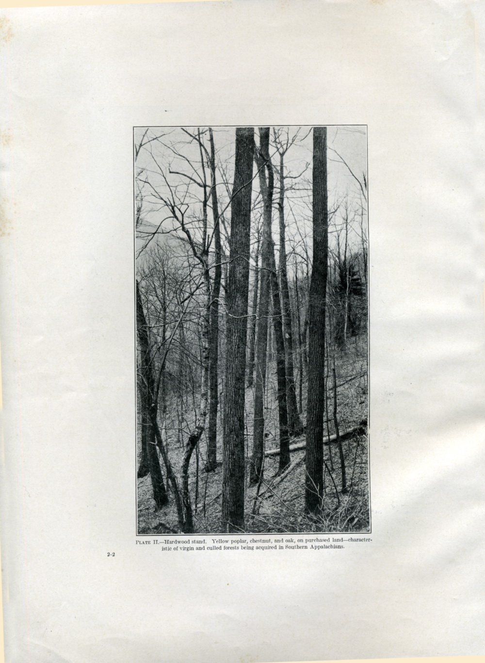
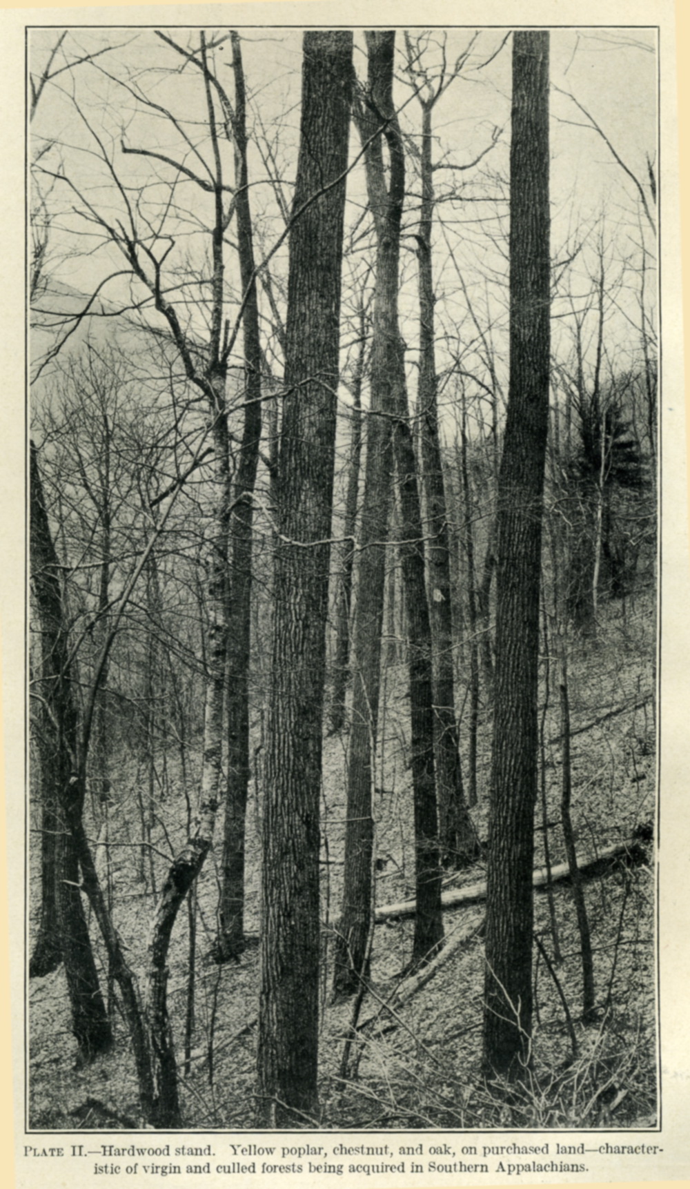
Plate II
Plate IIa |
|
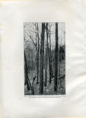
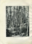
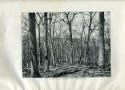
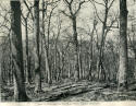
PLATEN II - Hardwood stand. Yellow poplar, chestnut, and oak, on
purchased land -- characteristic o virgin and culled forests being
acquired in Southern Appalachians. |
 |
| |
2 |
|
|
|
| |
3 |
|
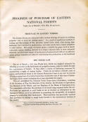
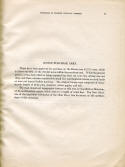
PROGRESS OF PURCHASE OF EASTERN NATIONAL
FORESTS
Under Act of March 1, 1911 (The Weeks Law).
SHORTAGE OF EASTERN TIMBER.
The Eastern States are confronted with a serious shortage of
lumber for building purposes,[1]
and of wood for making paper.[2]
As a result of injudicious methods of cutting and the ravages of
fire, privately owned forest lands, after having been lumbered, have
declined in productivity, and some tracts have ceased altogether to
yield returns. The supply of eastern spruce available for paper
stock is nearly exhausted, eastern building material is no longer
adequate fully to meet industrial demands, and the future supply of
hardwoods is threatened and will not be sufficient unless prompt
measures are taken for maintaining the productivity of the hardwood
forests.
THE WEEKS LAW.
The act of March 1, 1911 (the Weeks law), which was designed
primarily for affording protection to the headwaters of navigable
streams, seeks its results through the maintenance of forests. It
thus offers a means of furthering measures for maintaining a supply
of eastern timber. Under its provisions 1,841,934 acres of spruce
and hardwood forest in the Eastern States have been or are now in
process of being acquired out of a total of more than 50,000,000
acres of this class of timber-land upon which eastern industries
have been dependent for supply.
This act established the National Forest Reservation Commission,
consisting of the Secretary of War, the Secretary of the Interior,
the Secretary of Agriculture, two Members of the Senate, and two
Members of the House of Representatives. The commission authorizes
the purchase of all lands being acquired under the act. Purchases
are restricted to such lands as are so located, as determined by the
Geological Survey, as to be influential in promoting the
navigability of navigable streams by protecting their headwaters.
This restriction has practically required that purchases be limited
to rough lands located in the mountainous sections of the country.
[1]
Report, Secretary Southern Pine Association, January, 1919.
*"Committee American Paper arid Pulp Association, November, 1919.
157776—20
3 |
 |
| |
4 |
|
4
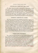
PURCHASE OF EASTERN NATIONAL FORESTS. APPROPRIATIONS WHICH HAVE
BEEN MADE.
The original Weeks bill carried an appropriation of $11,000,000,
covering several years, of which $3,000,000 was for the fiscal years
1910 and 1911, but it was possible to expend economically only
$17,000 of this appropriation for these years, leaving slightly more
than $8,000,000 available. To this, by the agricultural
appropriation bill of 1916, was added $3,000,000, being a
reappropriation of the moneys that had lapsed; and, by the
agricultural appropriation bill for the fiscal year 1920, there was
a further appropriation of $600,000. The commission has authorized
the expenditure of approximately all but $300,000 of these
appropriations.
ADDITIONAL APPROPRIATION NEEDED.
The National Forest Reservation Commission has now gone on
record in favor of a further appropriation for purchases to be used
both in the solidification of established areas and in the location
of new areas. As a result of this action of the commission, the
Secretary of the Treasury has transmitted to the Speaker of the
House (H. Doc. 321, 66th Cong., 2d sess.) a letter from Hon. Newton
D. Raker, president of the commission, submitting an estimate for an
appropriation needed for the acquisition of additional lands at the
headwaters of navigable streams under the provisions of the act of
March 1, 1911 (36 Stat., 961), known as the Weeks law. This
communication has been referred to the Committee on Agriculture. The
needed appropriation covers a period of five years, beginning with
the fiscal year 1921, at a rate of $2,000,000 per year. Rills have
already been introduced in both the Senate and the House of
Representatives authorizing the recommended appropriation.
FORESTS GOOD INVESTMENTS.
The 1,841,9,34 acres which have been or are being acquired are
being purchased at an average price of $5.26 an acre. It is believed
that purchases have been judiciously made and that, since the
merchantable timber has very greatly increased in value, they are
now worth much more than the amounts paid for them. In addition to
their protective function, these lands are already demonstrating
that financially they will be an excellent investment. There seems
to be a widespread opinion that the Government is acquiring very
largely cut-over or unproductive lands. This is by no means the
case, as is indicated by the income from the Forests. Many of the
purchases, however, are lands which through neglect by prior owners
have been burned and their earning capacity greatly reduced, or they
are cut-over lands or lands in young timber which can yield no
immediate returns, though all |
 |
| |
map 1 |
|
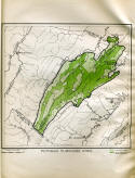
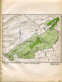
White Mountain Region (Also Green Mountain Region - Vermont) |
 |
| |
5 |
|
5
PURCHASE OF EASTERN NATIONAL FORESTS.lands so classed have
productive capacity. The cutting of timber by the Government on the
acquired lands is extremely conservative, less timber being sold
each year than the estimated annual replacement by growth. In spite
of these conditions, the receipts for the fiscal year 1919 on the
then acquired area of 1,347,660 acres amounted to $71,942.
NECESSITY FOR EASTERN NATIONAL FORESTS.
Increase in population and expansion of industry have been
confronted with a constantly decreasing acreage of timberland from
which to draw lumber, wood for paper manufacture, tanning materials,
and other uses. As a means of meeting this constant demand the
National Forests were created from the public domain. The purpose of
the National Forests was, by regulating cutting and by the
protection from fire of forest lands, especially when cut over, to
assure timber for future industrial use. These forests, however,
contain only about one-fifth of the timber supply of the country.
Furthermore, except for small and relatively unimportant areas in
Florida and Michigan, the entire forest system created from the
public domain is located west of the Mississippi River. There was at
the time of the establishment of the National Forests no adequate
provision for maintaining the timber supply of the Eastern States.
The eastern supply of hardwoods is of special importance since the
timber of this class is practically limited to the Eastern States
and to restricted areas within these States. Discussion covering a
number of years and looking particularly to measures for maintaining
a supply of hardwood timber for American industries eventually
culminated in the Weeks law.
BENEFITS FROM EASTERN PURCHASED FORESTS.
The Weeks law, for constitutional reasons, limits purchases to
lands which promote navigability of navigable streams. Rut the
benefits to navigation through the maintenance of an equable stream
flow by the conservation of the precipitation on the watersheds and
through reducing deposits of silt in channels are not the sole
advantages to be derived. As a provision for the maintenance of a
supply of hardwoods and of spruce for pulp and for airplane
construction the measure is of prime importance.
The tendency of the forest cover, when kept in good condition, to
promote absorption of heavy rainfall renders the maintenance of
woodland an essential consideration in any project seeking to
mitigate floods and to reduce flood losses on streams which head at
high altitudes in the eastern mountains. At the same time there is
ah accompanying benefit to water-power development in lessening
sedimentation, which lowers the storage capacity of reservoirs, as
well as in equalizing stream flowage, especially in increasing the
dry season flow.
157766—20------- 2
|
 |
| |
6 |
|
6
A collateral advantage is that enjoyed by such towns as secure their
supply of domestic water from watersheds in whole or in part owned
by the Government and lying within the forests. ' There are 17
municipalities, including 4 large hotels, which now make use of this
privilege, while 29 municipalities and 5 hotels secure their supply
from lands which have not been acquired but which are located within
the purchase areas. Government control assures the sanitation of
such watersheds without interfering with the use of the land for
timber producing purposes.A further
function which can not be measured from a purely monetary standpoint
is the use of the forests for recreational purposes. Rendered
accessible by means of roads and bypaths they become public
playgrounds. Also certain restricted areas have already been
designated as game preserves for the breeding of wild life, uses
which in no way detract from their essential economic service.
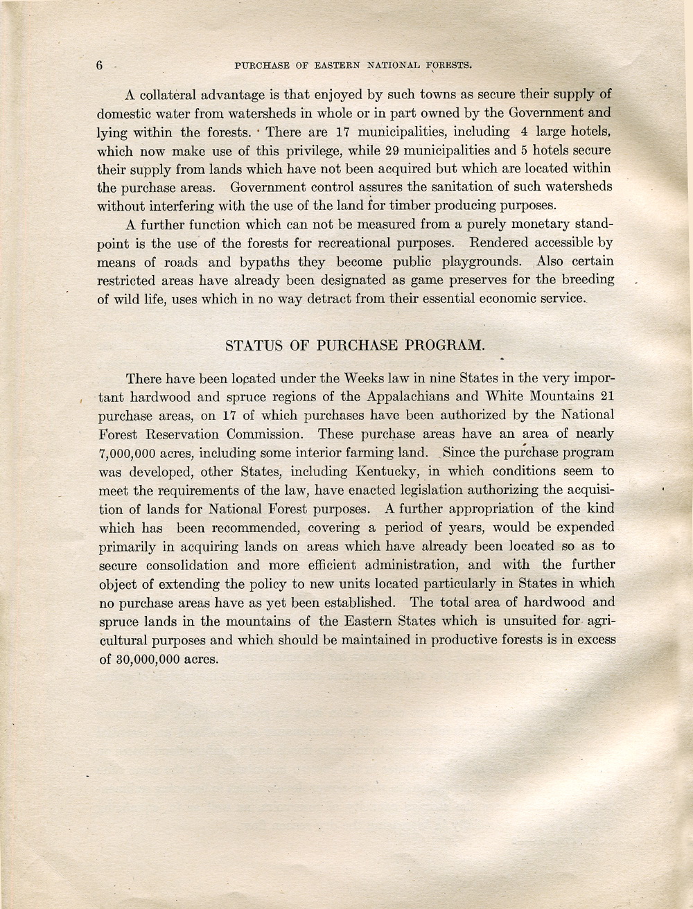
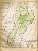
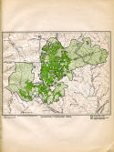
STATUS OF PURCHASE PROGRAM.
There have been located under the Weeks law
in nine States in the very important hardwood and spruce regions of
the Appalachians and White Mountains 21 purchase areas, on 17 of
which purchases have been authorized by the National Forest
Reservation Commission. These purchase areas have an area of nearly
7,000,000 acres, including some interior farming land. Since the
purchase program was developed, other States, including Kentucky, in
which conditions seem to meet the requirements of the law, have
enacted legislation authorizing the acquisition of lands for
National Forest purposes. A further appropriation of the kind which
has been recommended, covering a period of years, would be expended
primarily in acquiring lands on areas which have already been
located so as to secure consolidation and more efficient
administration, and with the further object of extending the policy
to new units located particularly in States in which no purchase
areas have as yet been established. The total area of hardwood and
spruce lands in the mountains of the Eastern States which is
unsuited for agricultural purposes and which should be maintained in
productive forests is in excess of 30,000,000 acres.
|
 |
| |
map 2a
map2b |
|
  |
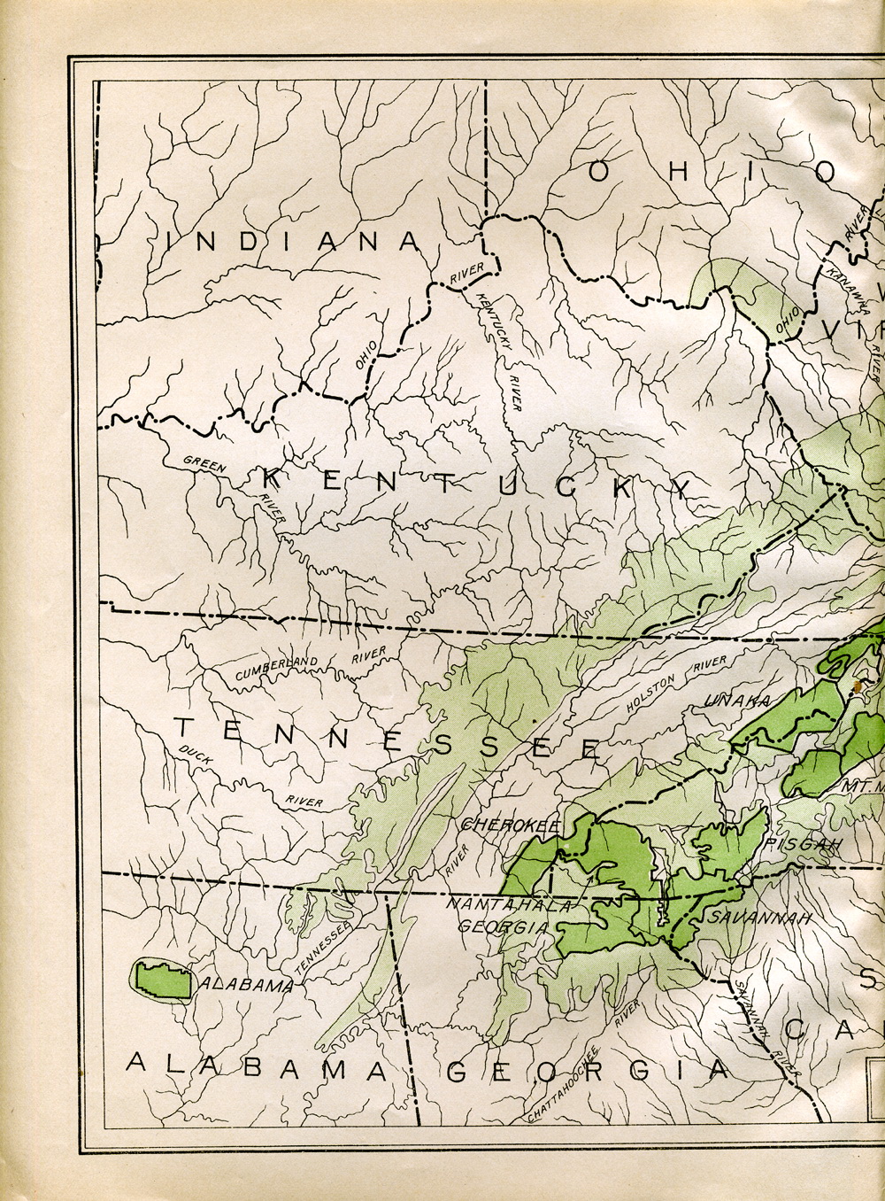
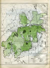
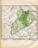
Southern Appalachian Region. Non - Agricultural Lands
Areas in which Lands for National Forests are being acquired. |
| |
Plate III
Plate IIIa |
|
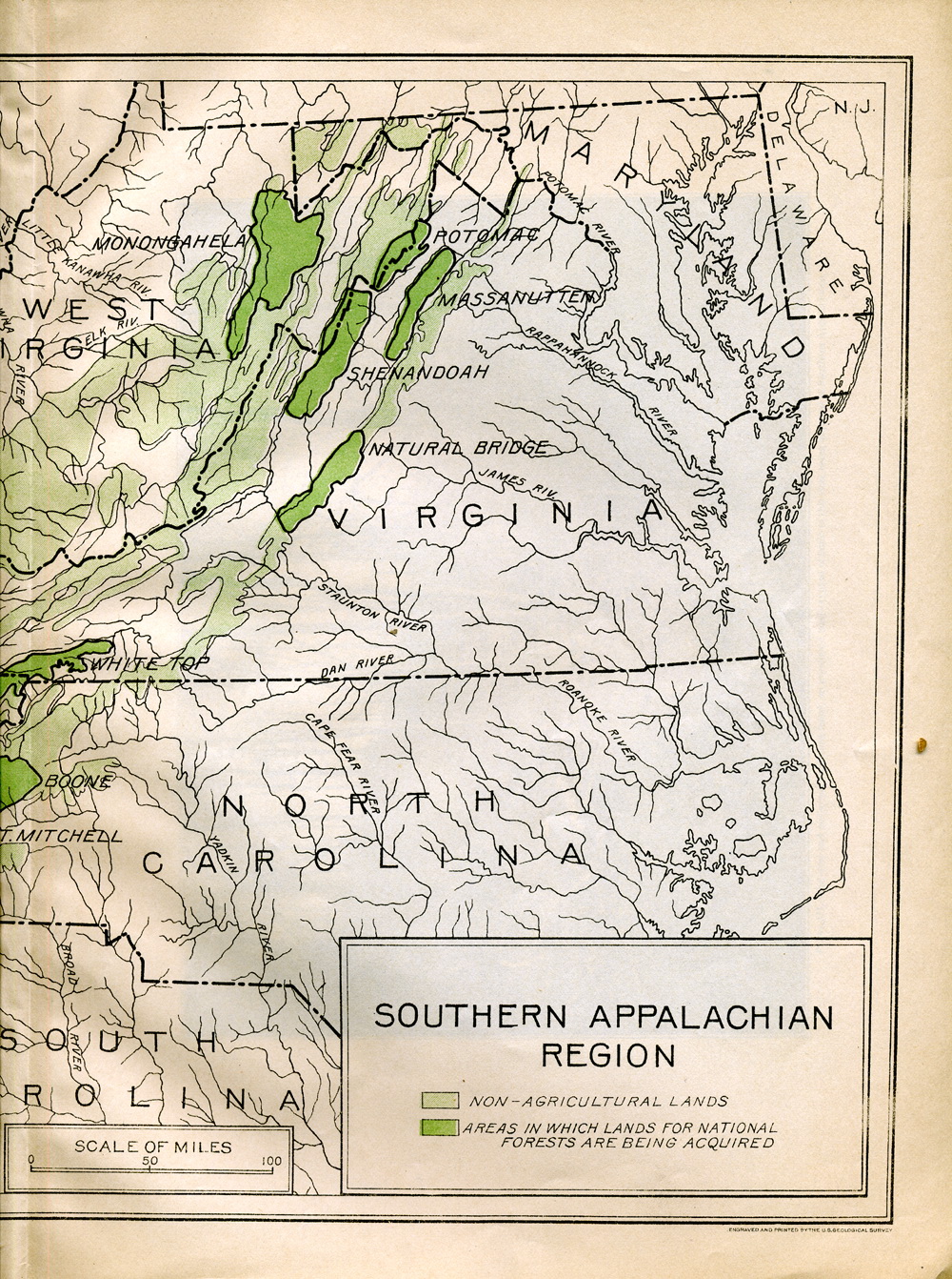
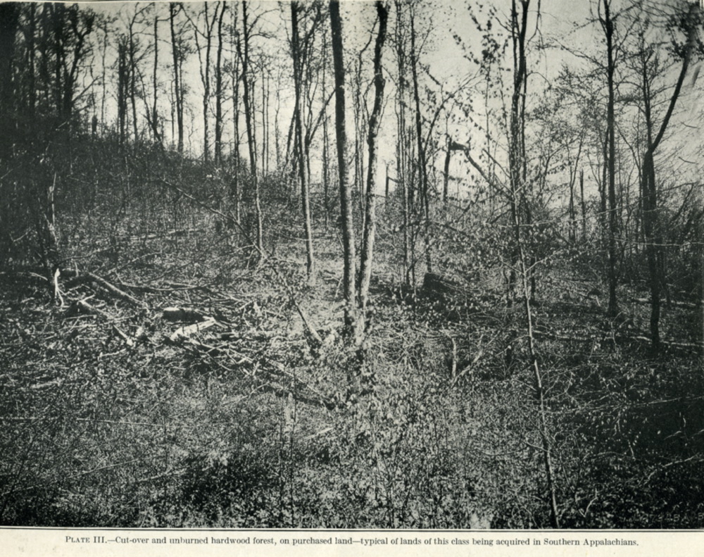
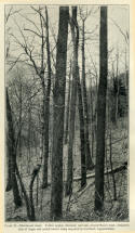
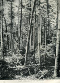
PLATE III - Cut-over and unburned hardwood forest, on purchased
land -- typical of lands of this class being acquired in Southern
Appalachians. |
 |
| |
Plate IV |
|
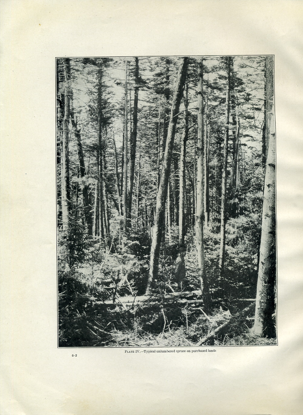
PLATE IV - Typical un-lumbered spruce on forest land. |
 |
| |
Plate V Plate Va |
|
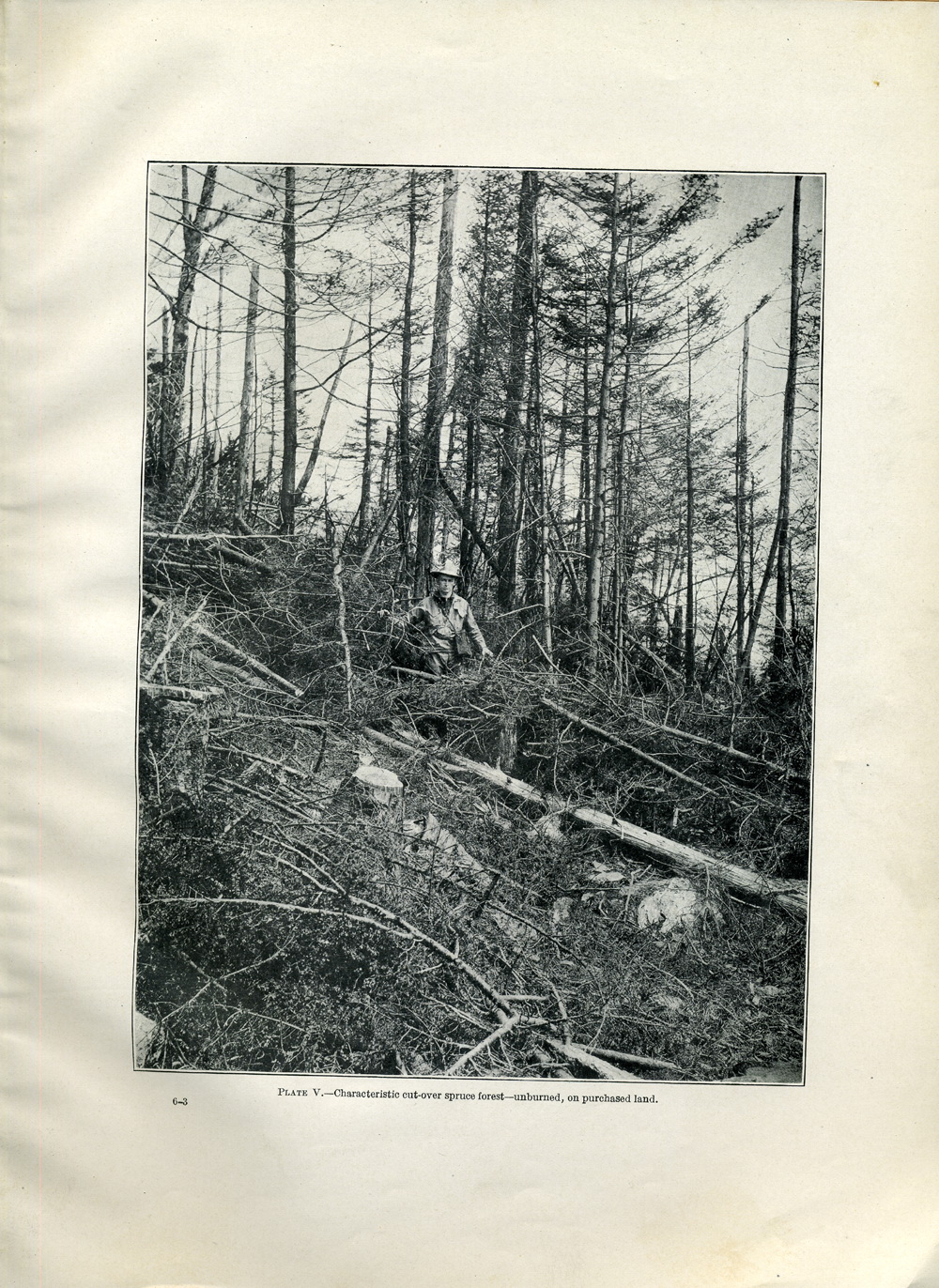
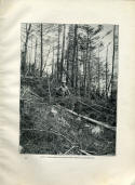
PLATE V - Characteristic cut-over spruce forest -
unburned, on purchased land.
[detail] |
 |
| |
Plate VI Plate VIa |
|
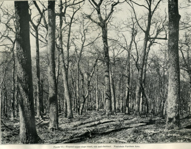
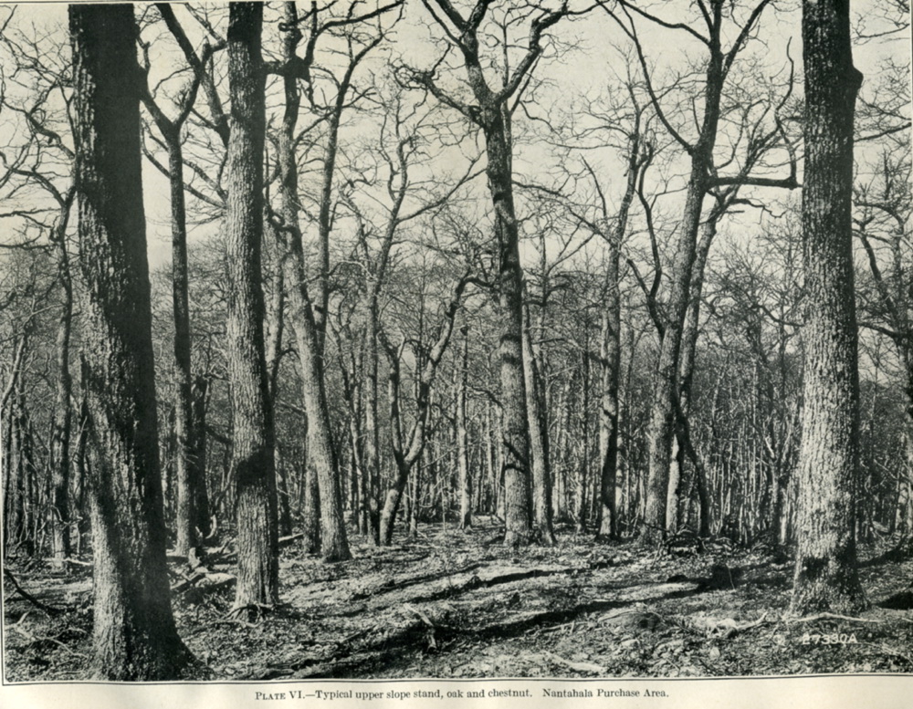
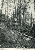
Plate VI, Typical upper slope stand,
oak and chestnut. Nantahala Purchase Area,
|
 |
| |
map 3 |
|
White Mountain Purchase Area |
 |
| |
7 |
|
7
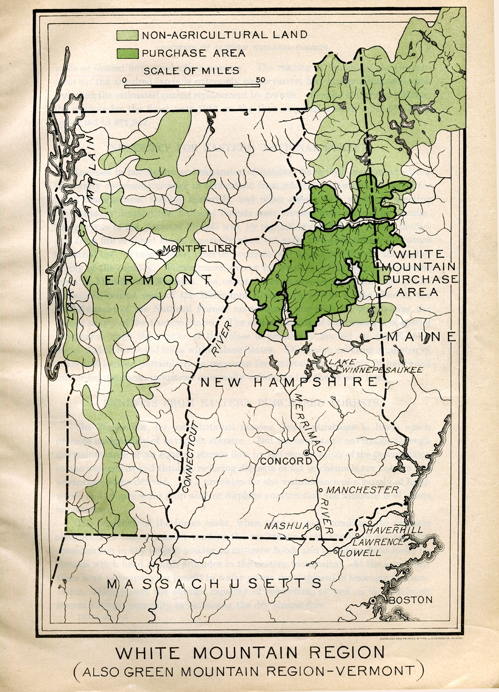
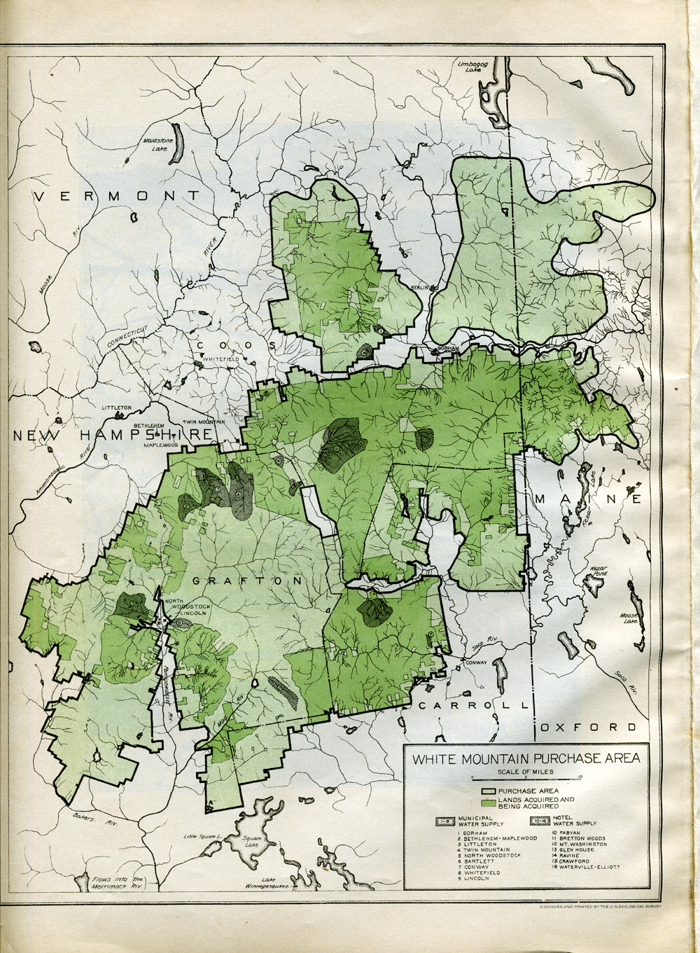
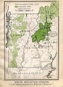
WHITE MOUNTAIN PURCHASE AREA.The
purchase program in the White Mountains is about one-half completed,
there having been approved for purchase 414,362 acres out of a total
designated area of 950,114. The White Mountains are the source of
the headwaters of the Androscoggin and Merrimac Rivers and of the
important tributaries of the Connecticut. The Merrimac is noteworthy
on account of the large development of water power upon it. The
Presidential Range, embracing the highest points in the northeastern
States, lies within this area; and all the high peaks, excepting the
very-summit of Mount Washington (altitude, 6,290 feet), are owned by
the Government.
The purchase program on this area looks
forward to the acquisition of interior holdings with a view to
solidifying the Government's lands as rapidly as lands are offered
by owners at reasonable prices, and negotiations are now in progress
for securing the high slopes on certain tracts before it may be
possible to acquire all of each tract. Among the lands which have
been approved for purchase are 270,000 acres of virgin and culled
forest extremely valuable as a source of spruce for paper pulp.
|
 |
| |
8 |
|
8
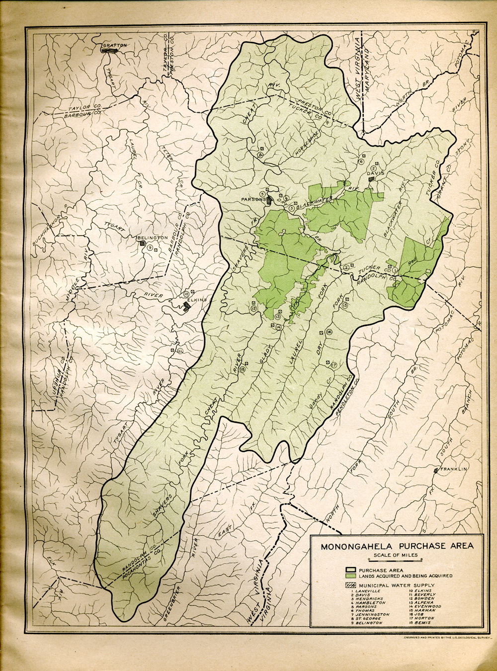
MONONGAHELA PURCHASE AREA.On the
Monongahela purchase area 59,499 acres, very largely of cut-over
lands have been approved for purchase out of 682,316 acres lying
within its limits. While there are several cleared valleys the
acquisition of which is not very desirable, at least 200,000 acres
lying especially east and south of lands the purchase of which has
already been approved should be acquired not only for the benefits
of watershed protection but so as to round out the administrative
unit'. Cutting on these lands, which were very heavily timbered, has
only recently been completed, so that they have become available for
consideration. A large portion of the lands which have been approved
for purchase bore forests of spruce, which was largely marketed for
paper-pulp stock. Such lands are potential spruce lands, and in
cases where they have not been burned are restocking naturally in
spruce; but the burned lands will require planting to reestablish
this valuable tree.
This purchase area is located on the
headwaters of the Monongahela River, a stream which has received the
benefit of very large Federal appropriations for its improvement. It
is a tributary of the Ohio River and. contributes largely to the
floods in the Ohio and the resulting property loss in Pittsburgh and
other river cities.
|
 |
| |
map 4 |
|
Monongahela Purchase Area |
 |
| |
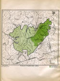
map 5 |
|
Potomac Purchase Area |
 |
| |
9 |
|
9
POTOMAC PURCHASE AREA.There have been
approved for purchase on the Potomac area 83,344 acres out of a
total of 146,038 acres. The remaining forest land within this area,
which is chiefly on rough mountain slopes, is largely held in small
parcels and can be secured advantageously only from time to time as
the owners desire to dispose of it. In addition to the forest lands
there are a number of small farms, located in the narrow parallel
valleys, the acquisition of which would not be desirable.
A considerable proportion of the land being
acquired on this area is well timbered, and none of it has been so
badly burned as to impair seriously its producing capacity. The
forests are largely of oak, a great deal being chestnut oak, the
bark of which is one of the important sources of tannin.
|
 |
| |
10 |
|
10
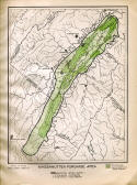
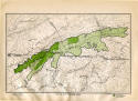
MASSANUTTEN PURCHASE AREA.On the
Massanutten purchase area there have been approved for purchase
63,537 acres out of a total of 152,946 acres. In addition to a
number of small tracts of woodland which adjoin lands already
approved for purchase and most of which should be acquired, there
still remains one large tract of rough land at the southern end of
the Massanutten Mountain which would largely fill in this portion
The forests on this area consist mostly of
young timber, much of which is oak; and while the rate of growth is
slow on account of the prevailing shallow and extremely stony soils,
nearly all of the land is capable of producing stands of
merchantable saw timber.
The highest point on the Massanutten Mountain
is the peak, which is about 3,000 feet in altitude.
|
 |
| |
map 6 |
|
Massanutten Purchase Area |
 |
| |
map 7 |
|
Shenandoah Purchase Area |
 |
| |
11 |
|
11
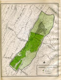
SHENANDOAH PURCHASE AREA.On the
Shenandoah purchase area, out of a total of 378,921 acres there have
been approved for purchase 187,979 acres located in the southern
and- central portions of the area. There still remain several large
tracts of rough land extending northward along the Shenandoah
Mountain and eastward on Elliotts Knob which should be acquired. The
forests consist largely of young oak and chestnut, but about 100,000
acres bear stands of merchantable timber.
The highest altitude is Elliotts Knob, 4,473
feet.
|
 |
| |
12 |
|
12
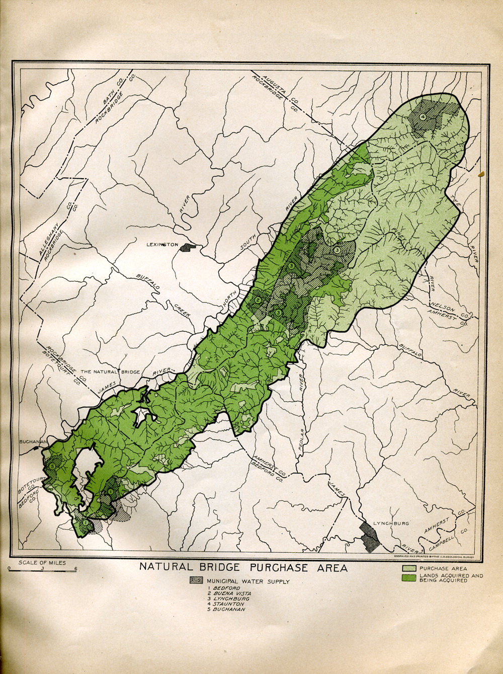
NATURAL BRIDGE PURCHASE AREA.On the
Natural Bridge purchase area 119,947 acres have been approved for
purchase out of a total of 262,064 acres. In addition to a number of
small farms the cleared land of which is chiefly located on steep
slopes and subject to deterioration through erosion, there are
several large tracts of very rough and comparatively light-timbered
lands at the extreme northwestern end of the area which should be
acquired. There are also heavily timbered lands along the
northeastern edge of the area now being operated which should be
acquired as soon as conditions permit.
The timber on this area consists largely of
oak and chestnut, there being on the acquired lands some extremely
valuable stands of mature timber as well as heavy stands of young
timber which have great investment possibilities.
The highest points on this area are the Peaks
of Otter, which reach altitudes of about 4,000 feet.
|
 |
| |
map 8 |
|
Natural Bridge Purchase Area |
 |
| |
map 9 |
|
White Top Purchase Area |
 |
| |
13 |
|
13
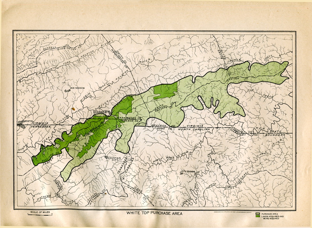
WHITE TOP PURCHASE AREA.On the White
Top purchase area 69,200 acres have been acquired out of a total of
274,253 acres. Stands of spruce constituted a large part of the
original forests. Some of these lands have been badly binned and
their earning capacity greatly reduced, but on the cut-over spruce
lands which have not been burned this species is being reestablished
naturally. Other portions of the area originally bore heavy stands
of white pine, and there is a valuable restocking of this species as
well as of oak and chestnut on the hardwood sites.
The highest altitudes on the White Top area
are White Top and Mount Rogers, a peak in the Balsam Mountains, the
altitudes of which are, respectively, 5,330 and 5,719 feet.
|
 |
| |
14 |
|
14
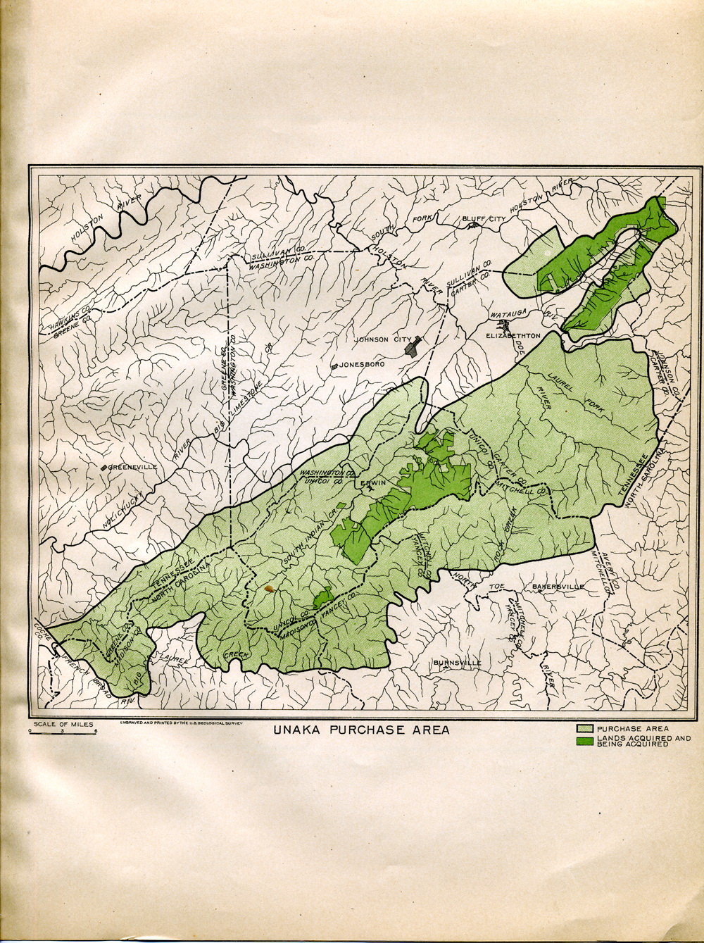
UNAKA PURCHASE AREA.On the Unaka
purchase area there have been approved for purchase 56,129 acres out
of a total of 517,147 acres. As a rule the stands of timber before
being cut are heavy and the cut-over lands have excellent producing
capacity. The important timbers are white pine, hemlock, chestnut,
oak, and yellow poplar. While it may not be desirable to acquire the
heaviest stands on account of the high price at which they are held,
the cut-over lands and the culled and lightly timbered lands,
especially at the south end of the area, should be acquired as
rapidly as they are offered.
The highest altitude is Bald Knob, 5,550
feet.
|
 |
| |
map 10 |
|
Unaka Purchase Area |
 |
| |
map 11 |
|
Boone Purchase Area |
 |
| |
15 |
|
15
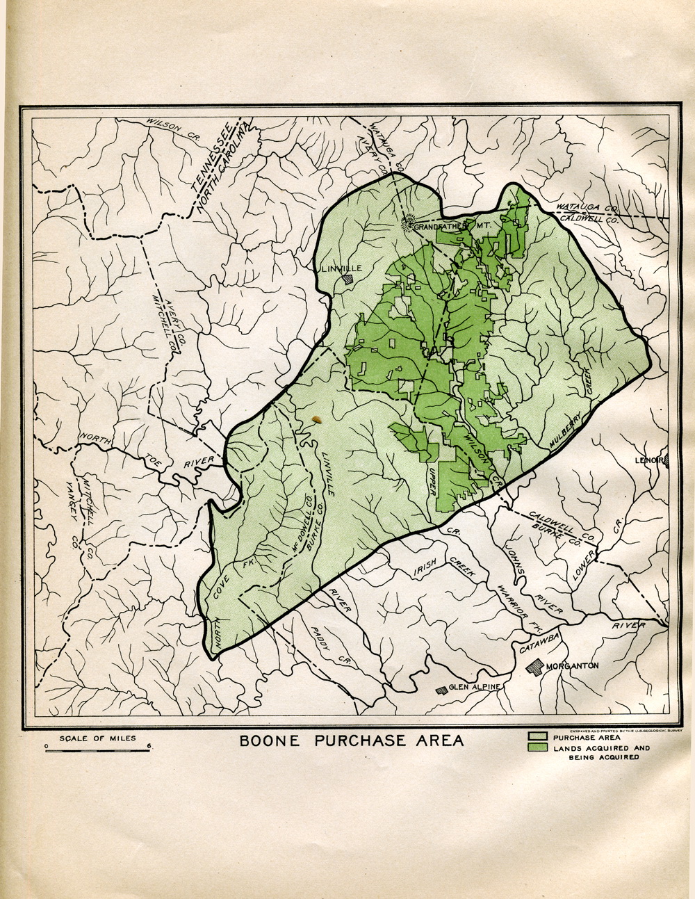
BOONE PURCHASE AREA.There have been
approved for purchase on the Boone area 47,775 acres, which is about
one-fifth of the 231,648 acres within the purchase area. While the
greater portion of the land which is being acquired has been cut
over, the cutting was not close, and there remains considerable
small but merchantable timber on such lands as were not burned
before purchase. The original forests were composed of heavy stands,
largely of white pine, chestnut, yellow poplar, and oak.
The most important topographic feature on
this area is Grandfather Mountain, at its northwestern corner, which
rises to a height of 5,964 feet. The New River, one of the important
tributaries of the Ohio River, has its source on the northern slope
of this mountain.
|
 |
| |
16 |
|
16
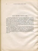
MOUNT MITCHELL PURCHASE AREA.On the
Mount Mitchell purchase area 89,795 acres have been approved for
purchase out of a total of 283,813 acres. The forests on this area
consist of spruce, the stands of which are located at the higher
altitudes; and hemlock, associated with hardwoods—the most important
being chestnut, oaks, yellow poplar, basswood, birch, and maple—the
stands of which are at lower altitudes. Some of the spruce land has
been burned over, but it has not been so severely injured as to
destroy the soil fertility or to prevent the establishment of a
future forest. Most of the acquired lands bear heavy and valuable
stands, chiefly of hemlock and hardwoods, but there are also small
areas of spruce.
Several municipalities, notably the city of
Asheville and the towns of Marion, Montreat, and Black Mountain, own
within the purchase area the watersheds from which they secure their
domestic supply of water, and are cooperating with the Government in
the protection of their lands from fire. Mount Mitchell and the
other peaks on the Black Mountains—the highest mountains in the
Eastern-States— rise to a general altitude of more than 6,500 feet
and occupy the center of the purchase area.
|
 |
| |
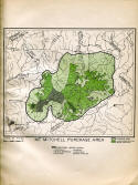
map 12 |
|
Mt. Mitchell Purchase Area |
 |
| |
map 13 |
|
Pisgah Purchase Area |
 |
| |
17 |
|
17
PISGAH PURCHASE AREA.On the Pisgah
purchase area 94,588 acres have been approved for purchase out of a
total of 304,350 acres. These acquired lands occupy a nearly solid
body on the eastern slope of Pisgah Ridge, the salient topographic
feature of which is Mount Pisgah, rising to a height of 5,713 feet.
Most of this land is being acquired subject to the rights of the
owners of the timber to cut it, but under the cutting regulations a
large amount of young timber will remain uncut and will pass to the
Government. The stand, which is very largely made up of chestnut
associated with oak and poplar, is an important source of supply for
tannic-acid stock. Much of the land on the area remaining unacquired
is spruce land, which is being cut over for stock for a near-bj'
paper mill. The soil fertility of this spruce land can be seriously
impaired by burning, and for this reason it should be acquired as
soon as possible after the completion of cutting, so as to assure a
replacement of the valuable spruce.
|
 |
| |
18 |
|
18
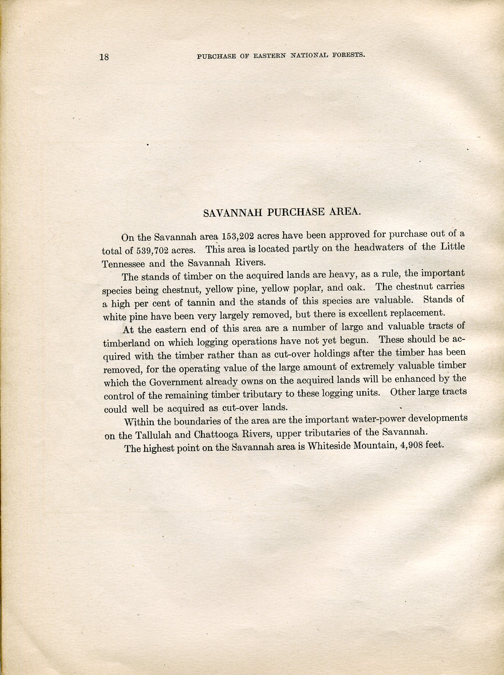
SAVANNAH PURCHASE AREA.On the Savannah
area 153,202 acres have been approved for purchase out of a total of
539,702 acres. This area is located partly on the headwaters of the
Little Tennessee and the Savannah Rivers.
The stands of timber on the acquired lands
are heavy, as a rule, the important species being chestnut, yellow
pine, yellow poplar, and oak. The chestnut carries a high per cent
of tannin and the stands of this species are valuable. Stands of
white pine have been very largely removed, but there is excellent
replacement.
At the eastern end of this area are a number
of large and valuable tracts of timberland on which logging
operations have not yet begun. These should be acquired with the
timber rather than as cut-over holdings after the timber has been
removed, for the operating value of the large amount of extremely
valuable timber which the Government already owns on the acquired
lands will be enhanced by the control of the remaining timber
tributary to these logging units. Other large tracts could well be
acquired as cut-over lands.
Within the boundaries of the area are the
important water-power developments on the Tallulah and Chattooga
Rivers, upper tributaries of the Savannah.
The highest point on the Savannah area is
Whiteside Mountain, 4,908 feet.
|
 |
| |
map 14 |
|
Savannah Purchase Area |
 |
| |
map 15 |
|
Georgia Purchase Area |
 |
| |
19 |
|
19
GEORGIA PURCHASE AREA.On the Georgia
area there have been approved for purchase 70,698 acres out of a
total of 337,272 acres.
This purchase area contains valuable
unlumbered stands of mixed hardwoods. In addition to several
thousand acres, largely in small holdings, which either adjoin lands
in process of being acquired or form interior holdings, there are
several large bodies of unlumbered timberland in the eastern and
northern portions of the area which should be acquired with the
timber or as soon as conditions of removal will permit.
The highest point on the area is Blood
Mountain, rising to an altitude of 4,463 feet.
|
 |
| |
20 |
|
20
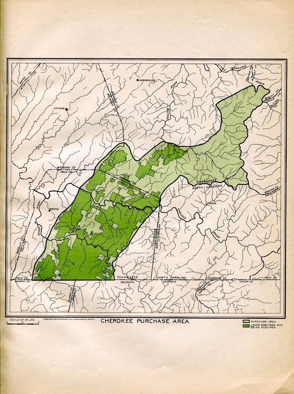
CHEROKEE PURCHASE AREA.A total of
143,336 acres out of 326,173 acres have been approved for purchase
on the Cherokee area. Most of the lands that have not yet been
considered are on the rough western flanks of the Unaka Mountains.
Some of the steepest slopes to be found in the Appalachians occur on
these lands and purchase should be extended to include them as soon
as the cutting of timber is completed.
This purchased area is located entirely on
the waters of the Tennessee River.
|
 |
| |
map 16 |
|
Cherokee Purchase Area |
 |
| |
map 17 |
|
Nantahala Purchase Area |
 |
| |
21 |
|
21
NANTAHALA PURCHASE AREA.On the
Nantahala purchase area 87,907 acres, including 11,369 acres
transferred from the Treasury Department, have been approved for
purchase out of a total of 497,011 acres. The lands approved for
purchase are largely in Macon County, N. C., and occupy the greater
portion of both slopes of the Nantahala Mountains, which rise to
heights of about 5,500 feet. The lands transferred from the Treasury
Department are located in Graham and Clay Counties, N. C., and
consist of some 30 parcels, most of which are well timbered and
valuable, as is the case with the surrounding privately owned land.
It seems desirable that the Government should acquire the
surrounding lands before they are lumbered, since they would form a
most valuable reserve of hardwood timber in connection with the
interlocking Government holdings.
The stands of timber on the acquired lands
are heavy and very largely composed of hemlock, chestnut, oak, and
yellow poplar.
Important water-power projects are located at
the extreme northern end of this area on the Little Tennessee River,
many of the tributaries of which are fed by streams which head on
this and the Savannah areas. One development necessitates a dam
across the Tennessee River more than 200 feet in height, but it is
understood that the storage capacity of the reservoir so created has
been reduced 10 per cent during the past five years by sedimentation
resulting from erosion of soil from the mountain slopes.
|
 |
| |
22 |
|
22
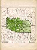
ALABAMA PURCHASE AREA.Out of a total
of 196,520 acres on the Alabama area there have been approved for
purchase 51,133 acres, in which are. included not however, 13,657
acres of public domain, the administration of which had been
transferred to the Forest Service.
The forests on this area consist largely of
pine on the upper slopes and extremely valuable stands of white oak
and poplar in the hollows.
The greater portion of the land in process of
being acquired is heavily wooded. Except certain small sections
adapted to farming, the remaining land within the area, which is
very largely in small holdings, should be secured as rapidly as
possible.
The greater portion of this area is located
on the drainage of the Black Warrior River, on which large
expenditures have been made to promote navigation.
|
 |
| |
map 18 |
|
Alabama Purchase Area |
 |
| |
23 |
|
23
ARKANSAS AND OZARK PURCHASE AREAS.On
the Arkansas and Ozark areas, which consist of the National Forests
of these names, there have been approved for purchase 27,812 acres,
all of which constitute interior holdings seriously interfering with
administration, especially grazing and protection against fire.
In addition to a number of small holdings,
most of them containing no cleared land or at most only sufficient
to establish a homestead claim, there are large areas lying within
the limits of each of these forests which should be acquired. These
are chiefly held by railroad and lumber companies and consist in
many cases of sections which alternate with those of the National
Forests. Such of these lands as can be secured with the timber will
add materially to the value of the timber owned by the Government on
the alternating sections by permitting the sale of timber on logical
logging units when the necessity for development arises. These lands
bear much valuable white oak and yellow pine.
|
 |
| |
back
cover |
|
NATIONAL FOREST RESERVATION COMMISSION
The Secretary of War,
President
The Secretary' of the Interior
The Secretary of Agriculture
Hon. John Walter Smith, United States Senator
Hon. Peter G. Gerry,-United States Senator
Hon. Willis C. Hawley, Member of Congress
Hon. Gordon Lee, Member of Congress
|
 |
| |
|
|
|
|
| |
|
|
|
|