Scale 100 poles
per Inch
By Virtue of a Warrant No. 2500
Entered the 13th of April 1824 surveyed
for Powel Ownby Fifty acres of Land on Rutherford County situate on both sides of Rock Creek of Main Broad River Including his Improvement Beginning at a poplar John Jackson's Corner thence So. 6 E.' 84 poles to a Stake on the No. bank of the Creek thence So. 84 W.' 96 poles to a stake a poplar on the side of a mountain thence No. 6 W.' 84 poles to a stake in John Jackson's line formerly now Harris Gillum's thence with Sd [said] line to the Beginning the 17th June 1825
Harris Gillum
F. Alexander F Alexander CS [County surveyor]
John Jackson
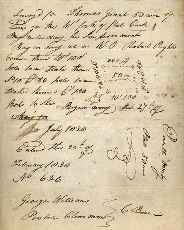
Surveyed for Thomas Grant 50 acres of Land on the W' fork of flat Creek Including his Improvement Beginning at a W.O. [white oak] Robert Right's Corner thence W' 100 poles to a stake thence So. 10 E. 86 poles to a stake thence E. 100 poles to the Beginning the 27th of
July 1830
Entered the 20th of
February 1830
No. 636
George Williams C. Bear [Chain Bearers]
Puston [?] Clemmons
By Virtue of a Warrant No. 2500
Entered the 13th of April 1824 surveyed
for Powel Ownby Fifty acres of Land on Rutherford County situate on both sides of Rock Creek of Main Broad River Including his Improvement Beginning at a poplar John Jackson's Corner thence So. 6 E.' 84 poles to a Stake on the No. bank of the Creek thence So. 84 W.' 96 poles to a stake a poplar on the side of a mountain thence No. 6 W.' 84 poles to a stake in John Jackson's line formerly now Harris Gillum's thence with Sd [said] line to the Beginning the 17th June 1825
Harris Gillum
F. Alexander F Alexander CS [County surveyor]
John Jackson
Surveyed for Thomas Grant 50 acres of Land on the W' fork of flat Creek Including his Improvement Beginning at a W.O. [white oak] Robert Right's Corner thence W' 100 poles to a stake thence So. 10 E. 86 poles to a stake thence E. 100 poles to the Beginning the 27th of
July 1830
Entered the 20th of
February 1830
No. 636
George Williams C. Bear [Chain Bearers]
Puston [?] Clemmons