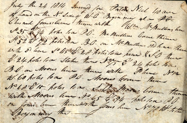
July the 24 1814
Surveyed for Paton Nick 40 acres of Land on the North side of W.O.
[possibly White Oak Creek] Beginning at a Chestnut Jones's Corner
thence with Wm. McMullins line So. 35 Et. 94 poles to a P.O. [post
oak] McMullin's Corner thence So. 52 Wt. 72 poles to a B.O. [black
oak] on McMullins's old line thence with sd [said] line So. 45 Et.
28 poles to a pine & S.O. thence Et. 24 poles to a Stake thence No.
75 Et. 24 poles to a B.O. [black oak] on Moore's line thence with Sd
[said] line No. 12 Wt. 60 poles to a P.O. [post oak] Moore's Corner
thence No. 68 Et. 15 poles to a S.O. Moore's Corner thence with
Moore's line No. 65 Et. 94 poles to a P.O. on Jones line thence with
Jones line No. 78 Wt. to the Beginning the -----