State of North Carolina
Henderson County
I hereby certify that being called upon by John Case
I have attended on the lands of the heirs of Myers
Deceased, on the water of Clear Creek, and
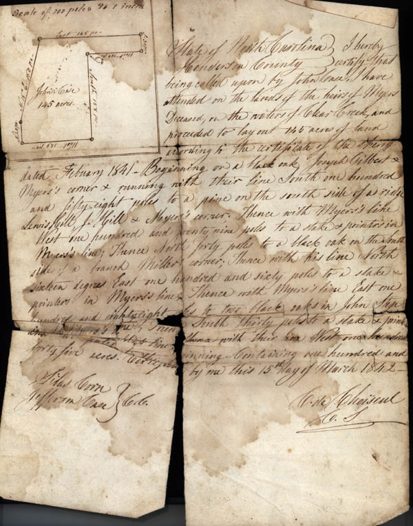
proceeded to lay out 145 acres of land according to the certificate of the sheriff dated February 1841. Beginning on a black oak Joseph Gilbert and Myers's corner and running with their line South one hundred and fifty eight poles to a pine on the south side of a ridge Lewis Hill, J. Hill and Myers's corner. Thence with Myers's line West one hundred and twenty nine poles to a stake and pointers in Myers's line; Thence North forty poles to a black oak on the South side of a branch Miller's corner; Thence with his line North sixteen degrees East one hundred and sixty poles to a stake and pointers in Myers's line; Thence with Myers's line East one hundred and eighty eight poles to two black oaks in John Step and Myers's line; Thence South thirty poles to a stake and pointers in Myers's and Gilbert's line then with their line West one hundred and two poles to the beginning- Containing one hundred and forty five acres. Certified by me this 15th day of March 1842.
Silas Corn / Jefferson Case C.B.[Chain Bearers]
C. Choiseue C. S.
Henderson County
I hereby certify that being called upon by John Case
I have attended on the lands of the heirs of Myers
Deceased, on the water of Clear Creek, and
proceeded to lay out 145 acres of land according to the certificate of the sheriff dated February 1841. Beginning on a black oak Joseph Gilbert and Myers's corner and running with their line South one hundred and fifty eight poles to a pine on the south side of a ridge Lewis Hill, J. Hill and Myers's corner. Thence with Myers's line West one hundred and twenty nine poles to a stake and pointers in Myers's line; Thence North forty poles to a black oak on the South side of a branch Miller's corner; Thence with his line North sixteen degrees East one hundred and sixty poles to a stake and pointers in Myers's line; Thence with Myers's line East one hundred and eighty eight poles to two black oaks in John Step and Myers's line; Thence South thirty poles to a stake and pointers in Myers's and Gilbert's line then with their line West one hundred and two poles to the beginning- Containing one hundred and forty five acres. Certified by me this 15th day of March 1842.
Silas Corn / Jefferson Case C.B.[Chain Bearers]
C. Choiseue C. S.