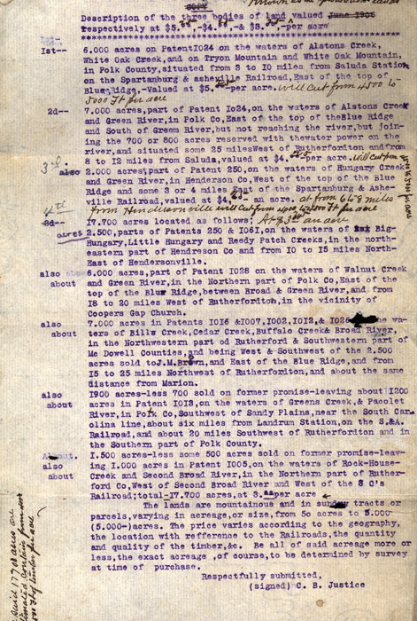
"Known as the speculation lands"
Copy
Description of the three bodies of land valued June
1906 respectively at $5.75, $4.35, -& $3.00,
-per acre
***************************************************************************************************************
1st-- 6.000 acres on Patent 1024 on the waters of
Alstons Creek, White Oak Creek, and on Tyron Mountain and White Oak
Mountain, in Polk County, situated from 3 to 10 Miles from Saluda
Station on the Spartanburg & asheville Railroad, East of the
top of Blue Ridge,-valued at $5.00 25- per acre.
will cut from 4500 to 5000 Ft per acre
2d-- 7.000 acres, part of Patent 1024, on the waters of Alstons
Creek and Green river, in Polk Co, East of the tip of the Blue Ridge and
South of Green River, but not reaching the river, but joining the 700 or
800 acres reserved with the water power on the river, and situated some
25 miles West of Rutherfordton and from 8 to 12 miles from Saluda,
valued at $4.0025 -per acre. Will cut
from 4500 to 5000 per acre also 2.000 acres, part
of Patent 250, on the waters of Hungary Creek and Green river, in
Henderson Co, West of the top of the Blue Ridge and some 3 or 4 miles
East of the Spartanburg & Asheville Railroad, valued at $4.00
25 - an acre. At from 6 to 8 miles from Hendersonville
will cut from 4,000 to 4500 ft per acre
3d-- 4th 17.700 acres located as
follows; At- $3.25 and acre 2.500, parts of Patents 250
& 1061, on the waters of Big Hungary, Little Hungary and Reedy Patch
Creeks, in the northeastern part of Henderson Co and from 10 to 15 miles
North East of Hendersonville.
Also about 6.000 acres, part of Patent 1028 on the waters of Walnut
Creek and Green River, in the Northern part of Polk Co, East of the top
of the Blue Ridge, between Broad & Green River, and from 18 to 20
miles West of Rutherfordton, in the vicinity of Coopers Gap Church.
Also about 7.000 acres in Patents 1016 & 1007, 1002, 1012, &
1026 the waters of Bills Creek, Cedar Creek, Buffalo Creek & Broad
River, in the Northwestern part of Rutherford & Southwestern part of
McDowell Counties, and being West & Southwest of the 2,500 acres
sold to J.M Brown, and East of the Blue Ridge, and from 15 to 25 miles
Northwest of Rutherfordton, and about the same distance from Marion.
Also about 1900 acres-less 700 sold on former promise-leaving about 1200
acres in Patent 1013, on the waters of Greens Creek, & Pacolet
River, in Polk Co, Southwest of Sandy Plains, near the South Carolina
line, about six miles from Landrum Station, on the S. & A. Railroad,
and about 20 miles Southwest of Rutherfordton and in the Southern part
of Polk County.
Also about 1.500 acres-less some 500 acres sold on former
promise-leaving 1.000 acres in Patent 1005, on the western
Rock-House-Creek and Second Broad River, in the Northern part of
Rutherford Co, West of Second Broad River and West of the 3 C's
Railroad; total -17.700 acres, at 3.00 per acre
The lands are mountainous
and in sundry tracts or parcels, varying in acreage, or size, from 50
acres to 5.00 (5.000-) acres. The price varies according to the
geography, the location with reference to the Railroads, the quantity
and quality of the timber, & c. Be all of said acreage more or
less, the exact acreage, of course, to be determined by survey at time
of purchase.
Respectfully submitted,
(signed) C.B. Justice [No signature]
The said 17700 acres are estimated contain from 4000 to 4500 Ft of timber per acre