2
County on the waters of Big, and Little Hungry Creeks and Reedy Patch Creek, in the north eastern part of Henderson County and from 10 to 15 miles N.E. from Hendersonville.
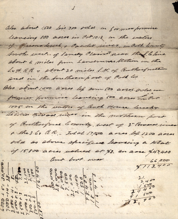
There are also about 6,000 acres in Patents 1028 on the waters of Walnut Creek and Green River in the northern part of Polk County and east of the top of the Blue Ridge and is from 18 to 20 miles west of Rutherfordton in the vicinity of [Coopers Gap??] Church The remainder of the 30,000 acres, say approximately 7,000 acres are parts of Patents 1016, 1007, 1002,1012, & 1026, on the waters of Bills Creek, Green Creek. Buffaloe Creek & Broad river in the north western part of Rutherford County & the South eastern part of McDowell County lying west & south west of the 2500 acres sold J. Brown, and east of the Blue ridge, and from 15 to 25 miles from Rutherfordton and about the same distance from Marion
County on the waters of Big, and Little Hungry Creeks and Reedy Patch Creek, in the north eastern part of Henderson County and from 10 to 15 miles N.E. from Hendersonville.
There are also about 6,000 acres in Patents 1028 on the waters of Walnut Creek and Green River in the northern part of Polk County and east of the top of the Blue Ridge and is from 18 to 20 miles west of Rutherfordton in the vicinity of [Coopers Gap??] Church The remainder of the 30,000 acres, say approximately 7,000 acres are parts of Patents 1016, 1007, 1002,1012, & 1026, on the waters of Bills Creek, Green Creek. Buffaloe Creek & Broad river in the north western part of Rutherford County & the South eastern part of McDowell County lying west & south west of the 2500 acres sold J. Brown, and east of the Blue ridge, and from 15 to 25 miles from Rutherfordton and about the same distance from Marion