April 28th 1819 survey
for Phillip Head one hundred aces of Land situate on the No. side of
a Creek of [about?] creek Beginning at a Red Oak sapling on Thomas
Edwards line there with T[?] line No 80 W. 68 poles to a pine
Edwards Corner thence with another Sqr. of So line So. 12 W. 108
poles to a poplar on Edwards line thence So. 75 @ 40 poles to a
stake and pointers on Charles Lewis line thence No 60 W. 36 poles to
a maple on the Creek Bank below the shoal on Lewis line thence up
the Creek as it meanders on the No. E. side to a Maple on Humphrey's
line thence with Humphreys line thence with Humphrys line No. 100
poles to a P>O> Hunt. corner thence So. 45 E. 250 poles to the Big
[Pine?]
Thomas Edwards & Miles Gosock[?] C bear [Chain Bearers]
[Backside]
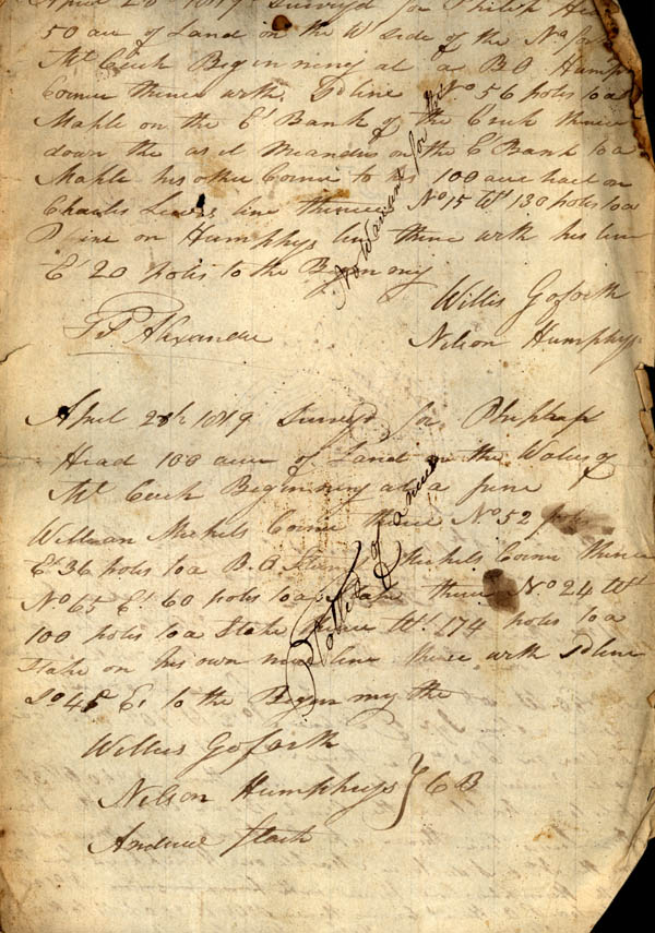
April 28th 1819 surveyed for Phillip Head 50 acre of Land on the W side of the No. fork of Mt Creek Beginning at a BO Humphrey Corner thence with So line No. 56 poles at Maples on the E Bank of the Creek thence down the as it meanders on the E Bank to a Maples his other Corner to his 100 acre tract on Charles Lewis line thence No 15 W 130 poles to a Pine on Humphreys line thence with his line E 20 poles to the beginning.
Frs. Alexander
Willis Goforth
Nelson Humphreys
April 28th 1819 Survey for Phillip Head 100 acres of Land on the Waters of Mt Creek Beginning at a pine William Mukets[?] Corner thence No 52 poles E 36 poles to a B.O. Steven Mukets corner thence No 65 E 60 poles to a stake thence No 24 W 100 poles to a stake thence W. 174 poles to a stake on his own nine[?] thence with So line So 45 E. to the Beginning line
Willus[?] Gofork
Nelson Humphreys
Andrew Stark [chain bearers]
