By virtue of a Warrant
No 2330 Entered the 10th day of July 1822 Surveyed for George
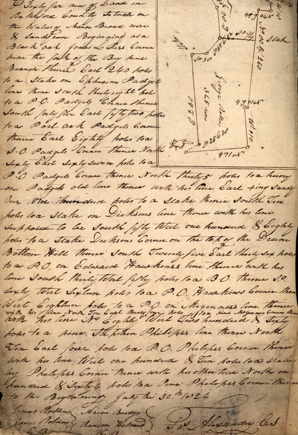
Rollins three hundred & sixty four acres of Land in RutherfoRd
County situate on the Waters of Main Broad river & Sandy run[.]
Beginning at a Black oak Jonas Liless corner from the fork of the
Big pine Branch thence East 240 poles to a stake on Ephriam Padgets
line then south thirty eight poles to a P.O. Padgets Corner thence
south forty five East fifty two poles to a Post Oak Padgets corner
thence East Eights Poles to a S.O. Padgets corner thence North Sixty
East sixty seven poles to a P.O. Padgets Corner thence North thirty
5 poles to a hickory[?] on Padgets old line thence with his line
East +ing Sandy run one hundred poles to a stake thence south ten
poles to a stake on Dicksons line thence with his line supposed to
be south fifty West one hundred & Eight poles to a stake Dicksons
corner on the top of the Drum Bottom Hill thence South Twenty five
East thirty six poles to a P.O on Edward Hawkins's line thence with
his lie south thirty West fifty poles to a B.O. thence So. sixty
West sixteen poles to a P.O. Hawkins's Corner then West Eighteen
poles to a P.O. on McGinness line thence with his line North ten
East thirty four poles to a line McGinness corner then [north?] his
line No. Eighty W Two hundred & sixty poles to a pine Stephen
Phillips line then North Ten East four poles to a P.O. Phillips's
corner thence with his line West one hundred & Ten poles to a Stake
by Phillips's Corner thence with his other line North and one
hundred & sixty 4 poles to a [Peter?] Phillips Corner thence to the
Beginning July the 30th 1824
Jonas Rollins
James Rollins [Chain Bearers]
Aaron Beedys
Ranson Holland [Chain Bearers
Jonas Rollins
James Rollins [Chain Bearers]
Aaron Beedys
Ranson Holland [Chain Bearers