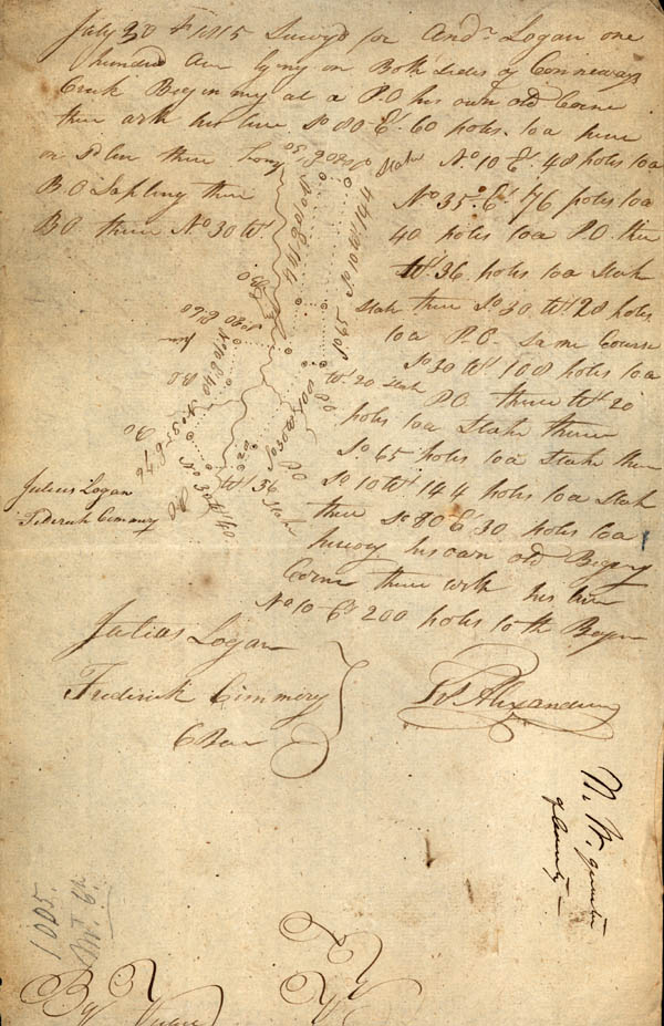
[Survey for Andrew Logan]
July 30th 1815 Survey for And. Logan one hundred acres lying on Both sides of [Conneways?] Creek beginning at a P.O his own old corner thence [ar...?] his line So 80 Et 60 poles to a pine on Sd line thence long stake No. 10 Et. 48 poles to a BO Sapling thence No 35 Et 76 poles to a BO thence No. 30 Wt. 40 poles to a P.O. then Wt. 36 poles to a stake stake thence So 30 Wt 28 poles to a P.O. same course So 30 Wt. 108 poles to a stake P.O thence Wt 20 poles to a stake thence So 65 poles to a stake thence So 65 poles to a stake thence So. 10 Wt. 144 poles to a stake thence So 80 Et 30 poles to a [hickory?] his own old Beginig[Beginning?] corner thence with his line No 10 Et 200 poles to the Beginning
Julius Logan
Frederick Cimmery [Chain Bearers]
Frs. Alexander
[Survey for Robert Rush]
By virtue of a Warrant No. 1136 Enterd the 13th of Ocbr 1813 Survyd for Robert Rush 400 acres of Land situate on the Waters of Mountain Creek Beginning at a pine & [...ony?] Millers Corner on Lewis line thence with Millers line No. 14 Et. 178 poles to a S.O. on Humphrys line then wrk Humprys line Wt. 96 poles to a Black Jack Humphrys corner then with his line No. 162 poles to a B.O. Humphrys corner thence So. 40 Wt 72 poles to a large [line?] thence So. 85 W. 210 poles to a Stake in Boyles line thence So. 230 poles to a Stake in or near Lewis or Dolloms line thence Et 236 poles to a stake in or near Lewis line thence No. 24 E 97 poles to a stake [G?] Lewis Corner thence with his line So. 66 Et 60 poles to the Begin thence 15the of Aug 1815
Thomas Edwards
Noah Largent [Chain Bearers]