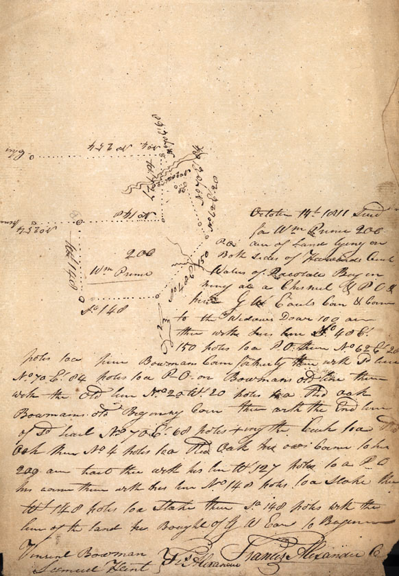
October 14th 1811 Survy for Wm Prince 200 acres of Land lying on
both sides of [Howards?] Creek Waters of Pacotate Beginning at a
Chesnut & PO &[line?] GW [Earls?] corner & corner to the Widows [Dowr?]
100 acres then with the line No. 48 Et. 150 poles to a P.O. then No.
62 Et. 20 poles to a pine Bowmans corner formerly thence with So
line No. 70 Et. 84 poles to a P.O. on Bowmans old line thence with
the old line No. 20 Wt. 20 poles to a Red Oak Bowmans old Beginning
corner thence with the end [line?] of Sd tract No. 4 poles to a Red
Oak his own corner to his 200 acre tract thence with his line W. 127
poles to a PO his corner thence with is line No. 148 poles to a
stake thence Wt. 148 poles to a stake thence So. 148 poles with the
line of the land the Bought of GW [Earl?] to Beginning
Vincent Bowman
Samuel Hunt [Chain Bearers]
FR Alexander
Francis Alexander CS [County Surveyor]
Vincent Bowman
Samuel Hunt [Chain Bearers]
FR Alexander
Francis Alexander CS [County Surveyor]