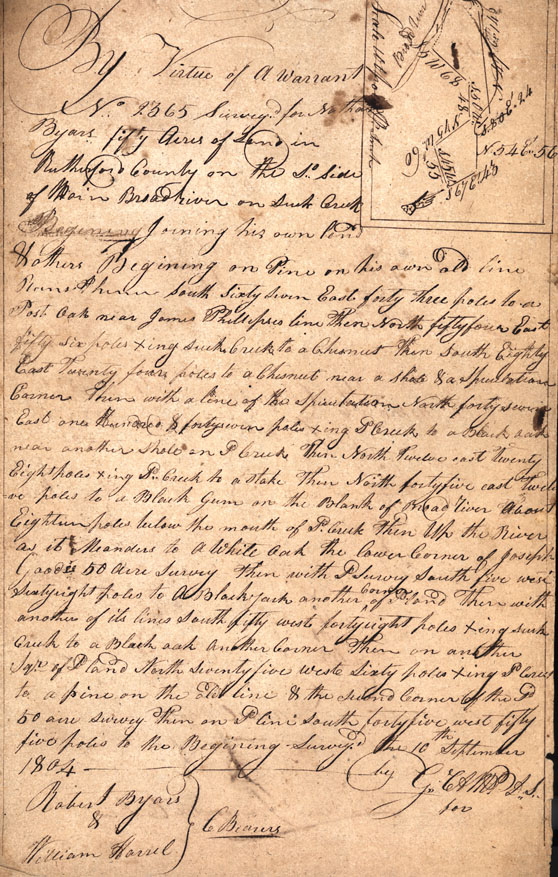
By Virtue of a Warrant
No 2365 Survey for Nathan Byars fifty acres of land in Rutherford
County on the So. side of Main Broad river on [South?] Creek
Beginning joining his own land & others Beginning on Pine on his own
old line [??] South sixtiy svne East forty three poles to a Post Oak
near James Phillipses line then North fifty four East fifty six
poles xing[crossing] [south?] Creek to a Chesnut Then South Eighty
East twenty four poles to a Chesnut near a shole & a Speculation
corner then with a line of the Speculation North forty seven East
one Hundred & fortyseven poles xing So Creek to a Black oak
nearanother shhole [iin?] So Creek then North twelve east twenty
Eight ples xing So. Creek to a stake then North fortyfive east
twelve poles to a Balck Gum on the Blank of Broad river about
Eighteen poles below the mouth of S. Creek then [W?] the River as it
meanders to a thie oak the lower corner of Josph Goads 50 acre survy
then wiht P survy South five west sixty right poles to a Blackjack
another corner of land there with another of its lines South fifty
west fortyeight poles xing [South?] creek to a black oak another
corner then on another Sqr. of land North seventy five west sixty
poles xing S. corner to a pine on the D line & the Second Corner of
the Sd 50 acre survey then on P lne south forty five west fifty five
poles to the Beginning Survey. The 10th September 1804 by
Robert Byars
William Harrel [Chain Bearers]
C Bearers
G CAM L.S.
for
Robert Byars
William Harrel [Chain Bearers]
C Bearers
G CAM L.S.
for
