| 11 | FACTS |
|
|
|
|
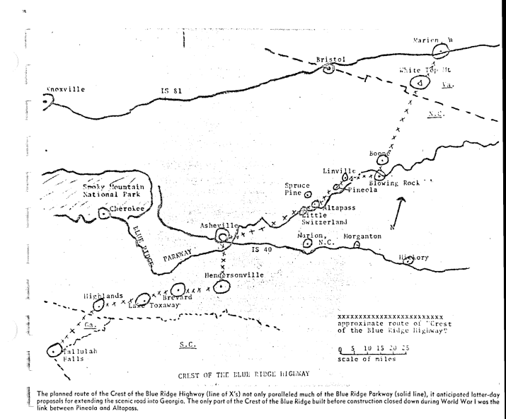
Before the Blue Ridge Parkway took shape, others imagined a roadway that would traverse the mountains of western North Carolina. One of these plans proposed by Dr. Joseph Hyde Pratt, was actually approved and begun but was stopped by demands placed on the country by WWI. The only completed section was that between Pineola and Altapass. This roadway was called the "Crest of the Blue Ridge Highway," and is represented on the map above by the small "x's". As the map notes, this earlier roadway roughly paralleled part of the route of the later Blue Ridge Parkway and continued the route into Georgia --- a plan that was pursued in the 1960's and 1970 through the office of Congressman Roy Taylor from western North Carolina, but again the plan was not realized. An Act was passed ( 82 Stat. 967, IX National Parkways, 1. Blue Ridge Parkway) but again, the plans were eclipsed by the expense of war. This time, it was the Viet Nam War. [See: 1968, below, and the Papers of Congressman Roy Arthur Taylor (1959 - 1977), D.H. Ramsey Library Special Collections, UNCA.] |
|
|
1868 |
Frederick Law Olmsted and his partner Calvert Vaux introduced the word "parkway" to describe the impressive boulevards they proposed in their 1868 report to the Brooklyn park commissioners. The term was used to describe the concept of a landscaped recreational road that functioned simultaneously as both a park and a way. [Davis, p.230] |
|
1880 |
The Good Roads Movement began in North Carolina in 1880. While the Blue Ridge Parkway was not technically a part of any "good roads" plan, or a statewide effort to improve the roads of North Carolina for commerce, it borrowed ideas from the earlier "Good Roads Movement," particularly influential was the manner in which the state of North Carolina interacted with the Federal government's effort to improve the roads of North Carolina for commerce. |
|
1920's |
The first parkways were designed to be safe and attractive approaches to suburban parks. The Brooklyn Eastern and Ocean Parkways were two of the first parkways constructed and were part of a network of parkways in Westchester County, New York commissioned by the Westchester County Park Commission in the 1920's. The Bronx River Parkway Reservation was the first public parkway designed explicitly for automobile use. [HAER Report, HAER No. NY-327] |
|
1928 |
The precursor to the Blue Ridge Parkway, the George Washington Memorial Parkway, in the Washington, D.C. area, later called the Mount Vernon Memorial Highway, was authorized in 1928 |
|
Skyline Drive, the Virginia precursor of the Blue Ridge Parkway, did not receive recognition as a national parkway because it was already within a national park; the Shenandoah National Park. |
|
|
1933 |
Senator Harry Byrd details the Parkway project September 28, 1933 and "Byrd Outlines Parkway Plan," appears in the Asheville Citizen. |
|
1933 |
November 16, 1933 the stakeholders in the proposed new parkway meet in Senator Harry Byrd's office where Byrd gives credit to McDonald for the proposal to create the parkway. |
|
1933 |
Stanley Abbott, a young 26 year old landscape architect was charged with the design and construction of the Blue Ridge Parkway in December of 1933. His intent according to the National Park Service was to construct a parkway that would "educate, soothe, and inspire over-urbanized Americans by allowing them to experience 'the look of homespun in an east that is chiefly silk and rayons.'" [Davis p. 237] In other words, the new parkway was to be constructed primarily for "urban tourists with ample incomes and leisure time." [Davis p.238] |
|
1933 |
Initial approval for funding of the Parkway came through allocations under the authority of the National Industrial Recovery Act (NIRA) of June 16, 1933, but the actual funding was executed at a meeting of a Special Board for Public Works on December 5, 1933. The initial allotment was $4 million dollars. At the time of the official allocation the estimated cost of the planned Parkway was $16.6 million and the cost of the land was to be picked up by the individual states. In 1987 when the Parkway was finally completed, over $130 million had been spent on construction. |
|
1934 |
Stanley Abbott, who worked out of the Roanoke office in 1934, was assisted by Edward H. Abbuehl and Hendrick E. van Gelder. William M. Austin was the Resident Engineer in the Bureau of Public road's Office in Roanoke, VA. Austin had been responsible for the earlier Skyline Drive and was closely aligned with Stanley Abbott in the planning of the Blue Ridge Parkway. |
|
Harold L. Ickes was Secretary of the Interior when the parkway was proposed by President Franklin D. Roosevelt. A "regionalist" at heart, Ickes found that even this ideology was ineffectual in building a good relationship with Harry Hopkins, FDR's New Deal guru. |
|
|
1934 |
The proposed route through North Carolina is described in this manner in
1934: |
|
1934 |
Description of the route through North Carolina proposed as a part of the scenic parkway to connect the Shenandoah National Park with the Great Smoky Mountains National Park, was submitted by the North Carolina Committee on Federal Parkways, appointed by Governor J.C.B. Ehringhaus, acting in conjunction with the North Carolina State Highway Commission, E.B. Jeffress, Chairman. |
|
The North Carolina Federal Parkway Committee included the following: |
|
|
1934 |
Contractors from throughout the country were hired to work on the Parkway. The primary coordinating Federal Parkway Engineer and the Senior Locating and Claim Engineer for the Blue Ridge Parkway was R. Getty Browning. It was Browning's maps that were given to the Secretary of the Interior in 1934 as preparation for the Parkway planning and which acted as the catalyst for the acceptance of the Blue Ridge Parkway plan. |
|
1934 |
The Parkway was the first large-scale scenic road built for the purpose of recreation constructed by the Federal Government and was followed by the Natchez Trace Parkway in 1934. The Natchez Trace Parkway that runs through Alabama, Tennessee, and Mississippi was begun in 1934 and authorized as a National Park in 1938 |
| 1935 | |
|
1935 |
Dispute with the Cherokee began regarding the proposed route through the Qualla Reservation. The dispute was not resolved until 1940. |
|
1935 |
Construction on the Parkway began on September 11, 1935 at Cumberland Knob (Milepost 217.55). Cumberland Knob is .6 miles south of the Virginia-North Carolina state-line. |
|
1936 |
The project was given its official name when Congressman Robert L. Doughton of North Carolina introduced legislation on June 30, 1936 to name the parkway the "Blue Ridge Parkway" and to officially make it a unit of the National Park System. |
|
The Blue Ridge Parkway is 470.02 total miles in length from Rockfish Gap at the southern end of the Shenadoah National Park in Virginia to the Oconaluftee area of the Great Smoky Mountains National Park in North Carolina. [Many "official" accounts give the length of the Parkway as 469 total miles.] |
|
|
1936 |
A.E. Demaray, the Associate Director of the National Park Service described the idea of "right-of-way" as a "strip of land acquired in fee simple to provide the area for the construction of the roadway and an insulating area to protect the natural values." The idea of fee simple amended the earlier plan for acquisition. The "right-of-way" was used to restrict access to the Parkway and to prevent road crossing along the way. The action was to prevent commercial and domestic dwellings from encroaching on the scenic nature of the Parkway. |
|
1939 |
The first segment of the road to open to the public was the 12 miles between N.C. 18 and U.S. 21 in Alleghany County, North Carolina which opened in April of 1939. |
|
1940 |
The dispute with the Cherokee was resolved successfully and construction began on Section 2Z. |
|
Construction of the Parkway took place in stages as the negotiation of right-of-ways took time and could not always be coordinated with construction. As was characteristic at that time the road was designed and constructed in sections. These sections were given alphanumeric designations that identify the state [1=Virginia, 2=NC] and section [letter of the alphabet]. So, for example, the last section at Oconaluftee Visitor Center is designated as part of Section 2Z. |
|
|
During WWII many engineers and laborers left for the war effort. Conscientious objectors filled in for many of the previous labor force. When WWII began approximately 170 miles were completed and approximately 160 miles were under construction. |
|
|
1942 |
Almost all Sections in Virginia had been purchased and right-of-way cleared, except an area close to Roanoke. |
|
1942 |
Approximately two thirds of the right-of-way had been acquired in North Carolina, and most of the remaining land was federally owned and part of the National Forests' holdings.. |
|
1948 |
The Moses Cone estate was donated in 1948. |
|
1949 |
The Julian Price Memorial Park was donated by the Jefferson Standard Life Insurance Company in 1949 |
|
1950's |
By the early 1950's only a little over half of the Blue Ridge Parkway was completed. |
|
Highly skilled rock masons were engaged to build the bridges, walls and tunnel facings along the route. |
|
|
Mapping the route of the Parkway was a difficult task as few maps, few roads, and little knowledge of many areas -- some possibly never before surveyed for any purpose, made mapping difficult. The landscape architects of that time traveled the route to determine the best views and where tunnels would be required. Sometimes they had to just travel "from ridge to ridge" to visually determine the best route. |
|
|
Rights of way were negotiated by the state of North Carolina, not by the Federal Government. The process was a difficult one as many land owners did not realize that the road would not service commercial traffic. |
|
|
The definition of a national parkway was defined by the Federal Government: the Policies on land easements and protection of scenic views were established by Federal agencies. |
|
|
Purchase of land for the Parkway went on for many years, particularly during the '50's. Several large parcels of land were transferred by interagency agreement from the U.S. Forest Service. Easements were granted for passage through U.S. Forest land. Donations of private land also occurred. and the , are significant donations to the Blue Ridge Parkway. |
|
| 1952 |
Linville Falls recreation area purchased and donated by John D. Rockefeller, Jr. in 1952 |
|
The restoration of burned-over areas, mediation of soil erosion, and fire control were instituted by the National Park Service. Training in crop rotation, soil conservation, and sustainable farm practice were given by Park officials. |
|
|
The primary work-force for the Blue Ridge Parkway were local residents. Some 90% of the work-force were from the regions along the Parkway. Only specialized labor was recruited from outside. |
|
|
The Civilian Conservation Corps (CCC) provided work-camps for Parkway laborers. |
|
|
1960 |
The next to the last section of the Parkway was completed in the 1960's and included the roadway that skirts the city of Asheville. |
|
1968 |
All Sections of the Parkway had been purchased and all right-of-ways cleared. Some small changes occurred after this date, but for all intensive purposes, the process of purchase was completed. |
|
1968 |
The last section, the Section 2H, was finally agreed upon and construction began on Grandfather Mountain at a mid-line level that required tunneling and the construction of a viaduct to reduce the environmental impact of the road. This last section would be the Parkway's most expensive section. |
|
1968 |
The Act to authorize the Secretary of the Interior to accept donations of land for, and to construct, administer, and maintain an extension of the Blue Ridge Parkway in the States of North Carolina and Georgia and for other purposes (82 Stat. 967, IX National Parkways, 1. Blue Ridge Parkway.) was entered into the Congressional Record but was never executed. 1968 CONGRESSIONAL RECORD ACCOUNT |
|
1972 |
In addition to the Blue Ridge Parkway, there are other National parkways, some came quite late, as did the . John D. Rockefeller Jr. Memorial Parkway in Wyoming, dedicated in 1972. |
|
1987 |
The final segment of the Parkway was the Linn Cove Viaduct that was constructed around Grandfather Mountain and was completed in 1987. This viaduct is also one of the most expensive segments of the Parkway. |
|
1987 |
Upon completion of the Blue Ridge Parkway in 1987, the estimated costs of construction was calculated to be over $130 million had been spent on construction. Total cost here does not include the cost of the purchase of land which was paid by the individual states. |
|
2000 |
Current (2000) visitors to the Parkway average 17 million visitors per year |
|
In the Southern Appalachians there are 188 mountain peaks that reach 5,000 feet or more in elevation, 102 of these mountains are either traversed, touched, or within close range of the Parkway. |
|
|
There are over 3000 miles of trout streams in western North Carolina and 1/3 of them have their head waters along the slopes of the Parkway. |
|
|
There are two National Game Preserves that are penetrated by the Parkway. They are Mount Mitchell and Mount Pisgah. |
|
|
The Parkway ends in the Qualla Boundary, the Cherokee Indian reservation which is surrounded on three sides by the Great Smoky Mountains National Park. |
|
|
2008-2009 |
According to the 2008-2009 Blue Ridge Parkway Visitor Survey there are 9 counties through which the Parkway runs, that have no urban centers [An urbanized area is defined by a population of at least 50,000 inhabitants by the U.S. Census.] |
|
The U.S. National Park Service is the largest conservator of historic landscapes in the United States. It has developed, and is continuing to develop, a wide range of policies to deal with the often contradictory and ambiguous problems of conserving historic natural landscapes. |
|
|
The Parkway is the longest road ever proposed in America as a continuous unit up to that time. |
|
|
216.95 miles of the Parkway are in Virginia |
|
|
253.07 miles of the Parkway are in North Carolina. |
|
|
The total acreage of Federal land within the Parkway is 79,493.71 acres. |
|
|
33,953.22 acres of Parkway land falls within Virginia |
|
|
45,579.49 acres of Parkway land falls within North Carolina |
|
|
The lowest point along the Blue Ridge Parkway is 649 feet above sea level where the Parkway runs along the James River in Virginia. The highest point along the Parkway is 6,053 at Richland Balsam, in North Carolina. |
|
|
2008 |
The highest percentage of land under federal ownership along the Parkway is in Swain County, NC where 71 percent of the land is federally owned. The lowest percentage is in Surry County, where only 0.3 percent is under federal control. |
|
|
|