[Page 1]
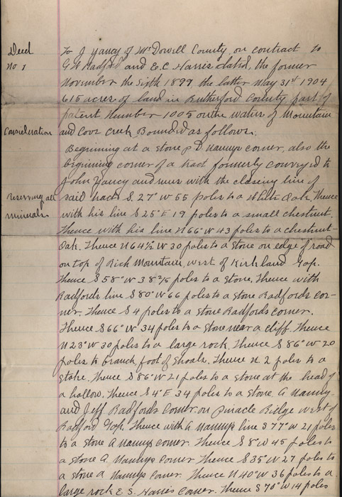
Deed no 1 To J Yancy of McDowell County on contract to GW Radford and E.C. Harris dated, the former November the sixth 1899, the latter May 31st 1904 615 acres of land in Rutherford County part of patent Number 1005 on the waters of Mountain and Cove creek Bounded as follows:
Beginning at a stone p.D. [Naunys?] corner, also the beginning corner of a tract formerly conveyed to John Yancy and runs with the closing line of said tract S. 27 [degrees] W 55 poles to a White Oak. Thence with his line S 25 [degrees] E 19 poles to a small chestnut. Thence with his line N 66 [degrees] W 43 poles to a chestnut Oak. Thence N 64 1/2 W 30 poles to a stone on edge of road on top of Rich Mountain, west of Kirkland Gap. Thence S58[degrees] W 38 2/5 poles to a stone. Thence with Radford's' line S 80 [degrees] W 66 poles to a stone Radford's corner. Thence S 4 poles to a stone near a cliff. Thence N 23 [degrees] W 30 poles to a large rock. Thence S 86 [degrees] W 20 poles to branch, foot of shoals. Thence N 2 poles to a stake. Thence S 86 W 21 poles to a stone at t6he head of a hallow. Thence S 4 E 34 poles to a stone. G. [Nauny?] and Jeff Radford's corner on pinacle Ridge west of Radford Gap. Thence with a [Nauny's?] line S 77 W 21 poles to a stone A [Nauny's?] corner. Thence S 8 W 45 poles to a stone A [Nauny's?] corner Thence S 35 W 27 poles to a stone A. [Nauny's?] corner. Thence N 40 W 36 poles to a large rock E.S. Harris corner. Thence S 70 W 14 poles