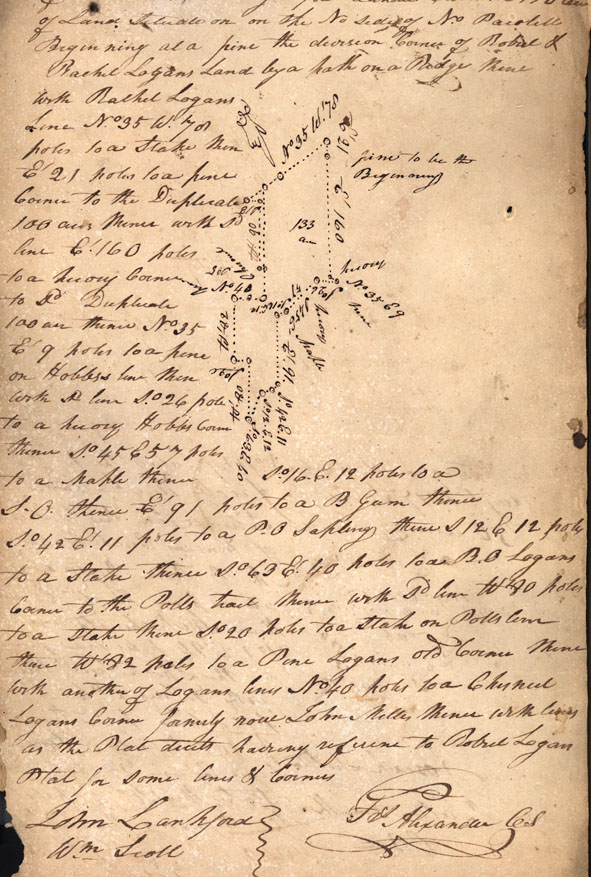
By Virtue of a Warrant
No 1446 Entered the 8th of Octbr 1816 Surveyd for Lander Carruth 150
acres of Land situate on on the No side of No Pacolete Beginning at
a pine the division Corner of Robert & Rachel Logans Land by a path
on a Ridge thence with Rachel Logans line No 35 W. 78 poles t a
stake then Et 21 poles to a pine corner to the Duplicate 100 acres
thence with Sd line Et. 160 poles to a [hickory?] corner to Sd
Duplicate 100 acre thence No. 35 Et 9 poles to a pine on Hobbs line
then with Sd line So. 26 pole to a [hickory?] Hobbs corner thence
So. 45 E 57 poles to a maple thence S. 16 E. 19 poles to a S.O.
thence Et. 91 poles to a B Gum thence So. 42 Et 11 poles to a P.O
Sapling thence S 12 E 12 poles to a stake thence So. 63 Et. 40 poles
to a B.O Logans corer to the Polls tract thence with Sd line Wt 80
poles to a stake thence So. 20 poles to a stake on Polls corner
thence Wt. 82 poles to a Pine Logans old corner thence with another
of Logans lines No. 40 poles to a Chesnut Logans corner formerly now
John Miller thence with lines as the Plat tracts having reference to
Robert Logan plat for some lines & corners
John Lankford
Wm. Scott [Chain Bearers]
Frs. Alexander CS [County Surveyor]
John Lankford
Wm. Scott [Chain Bearers]
Frs. Alexander CS [County Surveyor]