Cleveland County |
|
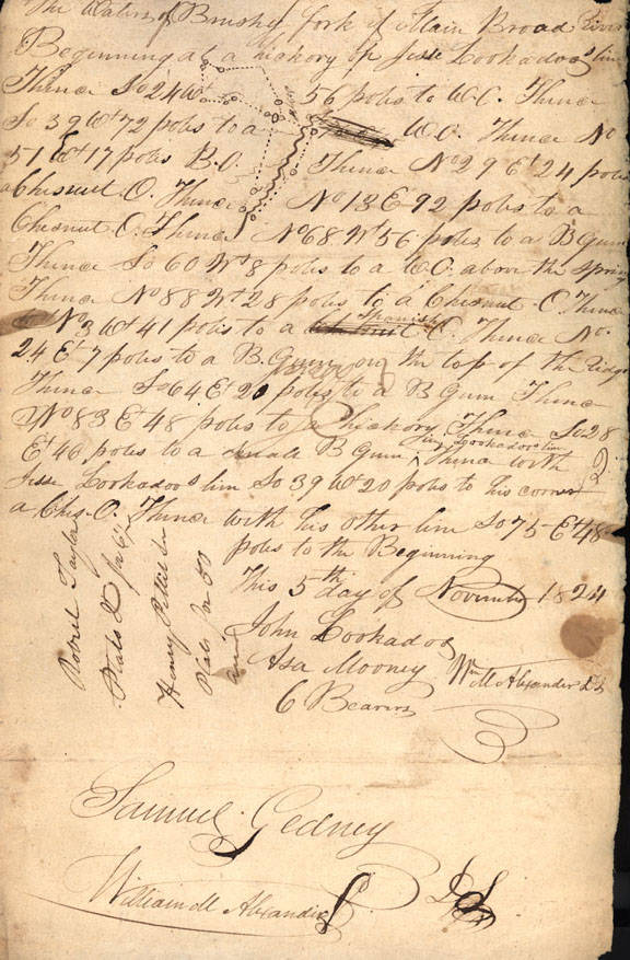
The original spelling of the county was "Cleaveland" after Colonel Benjamin Cleaveland, a noted partisan leader of the western Carolina frontier and one of the heroes at Kings Mountain during the Revolutionary War. This was a pivotal and significant victory by American Patriots over American Loyalists during the Southern Campaign of the Revolutionary War. The present spelling became the standard in 1887. From any of the elevations in the county the Blue Ridge is plainly visible. The first settlers in the Cleveland County area arrived in in the 1750's. At the beginning of 1760, this territory was Lincoln County. Anson and Rowan counties were the westernmost counties in the state. In 1752, Mecklenburg was created from Anson. The early settlers of Cleveland county lands were mostly Scotch-Irish and Germans. Samuel S. Gidney, a surveyor who settled on the banks of the First Broad River in present day Cleveland County in 1825, agreed to accompany Jacob Hyatt on his travels, and continued to work with resident agent Joshua Forman of the Speculation Land Company until 1839. Hyatt, on his tour through Rutherford County, was in territory now belonging to Cleveland County, and commented that Patent 1038 "is somewhat broken but the greatest part is good Land lays handsome and well timbered." |
| Related documents: |
|
0001 map |
|
Bibliography: |
|
Corbitt, David Leroy. The Formation of the North Carolina Counties 1633-1943. Raleigh: North Carolina Department of Cultural Resources, 1950. Our Heritage: A history of Cleveland County. Shelby, North Carolina: The Shelby Daily Star, 1976. Roundtree, Lynn. The Robbins Collection of Speculation Land Company Records. Armadilo Books:Chapel Hill, NC, 2002 |