|
Box |
Page |
Description |
Thumbnail |
| |
Front Inside Cover, 1 |
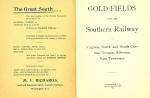
"The Great South..."
"Gold Fields Along the Southern Railway
in Virginia, North and South Carolina, Georgia, Alabama, East Tennessee" |
|
| |
2,3 |
Gold in the South
The gold belt of the States of Virginia, North and South
Carolina, Georgia and Alabama has unquestionably been greatly neglected,
both by the practical miners and the capitalists of the country. The gold
deposits of the Southern States are no new discovery, Mines were opened
two generations ago and have been worked with varying success of and on
ever since. The rich discoveries in the West drew attention away from
these mines, and the fact that there was no method by which all the ores
could be worked and their true value realized caused mines partly
developed to be abandoned. Several fortunes have been made from the better
worked and better known mines. With the improvements in mining and milling
processes which have come about within the past few years new attention
ahs been directed to these Southern gold fields. Old mines are again being
developed and found to have most valuable deposits, and new ones in new
localities are being discovered. The modern processes will enable these
Southern gold mines to be worked to the fullest extent, and the world will
probably soon awaken to the fact that what was popularly supposed to be a
worked-out region is in reality one of the greatest gold-bearing belts of
the continent. In Virginia, the Carolinas, Georgia and Alabama there are a
great many of the best opportunities for the investment of capital in the
developing and working of mines, and the pioneers in giving attention to
this gold region will reap great returns. Mining properties in the South
can be purchased very cheaply, and with experienced and intelligent mining
operations can be conducted at small cost. The articles following on the
gold belts of the various States will fully describe the character of the
country and the deposits and give the practical miner an idea of the
character of work to be done and the results which can be reached. The
miner will desire to look over the ground himself, make his own
investigations. Personal examination is always best, and it is to be hoped
that very many of those interested in the development of precious metal |
|
| |
4,5 |
mines of the country will make exploration trips through
the Southern States. The gold belts as a rule, starting in Virginia, run
northeast and southwest. Going south the deposits end in the State of
Alabama. The gold fields of the South are along or adjacent to lines of
the Southern Railway, and the Land and Industrial Department of that road
will extend its assistance to all who desire to look up the opportunities
for profitable mining. A careful reading of the articles in this little
book will certainly more than pay for the time occupied.
"Gold Deposits in Virginia"
The gold ores of the Southern Appalachian States occur in the Piedmont and
Mountain regions throughout the great belt of crystalline and metamorphic
rocks stretching in a southwesterly direction from Maryland to Alabama 600
to 700 miles in length, and 50 to 150 miles in width. This broad area may
be subdivided into several minor gold-bearing belts: 1)The Virginia belt;
2) the eastern Carolina belt; 3) the Carolina slate belt; 4) the Carolina
igneous belt; 5) the King's Mountain belt; 6) the South Mountain belt; 7)
the Georgia belt; 8) the Alabama belt.
While gold mining in Virginia has not reached proportions as large as in
the Carolinas and Georgia, yet a considerable amount of prospecting and
mining work has been done, and there are some promising deposits in the
Appalachian region of the State. This gold belt, which begins in Maryland
and extends into North Carolina, lies just east of the Blue Ridge. It has
a width of from 10 to 20 miles, and covers an area of about 4,000 square
miles, mainly in Fauquier, Culpeper, Stafford, Orange, Spottsylvania,
Louisa, Fluvanna, Goochland and Buckingham counties. There is another
small and less important gold belt lying just west of the Blue Ridge,
mainly in Floyd, Montgomery and Grayson counties, but this are embraces as
far as exploited, mainly placer deposits, and these of no large
importance.
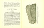
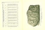
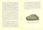
"Nugget Found at Crawford Mine, Stanley County, N.C., near Southern
Railway, April 8, 1895. Weight 8 pounds 5 ounces. Picture about
three-fifths actual size." |
|
| |
6,7 |
The country rocks of this main belt east of the Blue Ridge
are mainly mica, gneiss and mica schist, which are in places often
hydromicaceous, chloritic or garnetiferous in character. T hey have a
general strike of N. 20-30 degrees E, and a varying easterly dip. T he
gold is usually carried in irregular lenticular quartz veins, which lie
more or less parallel to both the strike and dip of the rock, and varying
in width from a few inches to several feet. In many cases both the vein
quartz and the slate walls are impregnated with gold-bearing pyrites. Some
of these veins are quite limited, while others, such as the Fisher lode in
Louisa County, are quite extensive, both in depth and length. Most of the
gold thus far obtained has come from the veins and the contiguous schists,
but some placer deposits have been discovered and worked. The total output
of precious metals from the Virginia mines to date amounts to something
more than $3,200,000.
A considerable number of mines have been opened up at intervals in
Fauquier, Stafford, Culpeper, Orange and Spottsylvania counties which are
grouped about the junction of the Rapidan and Rappahannock Rivers. Thus
the Franklin, Wycoff and Leopold mines are located in the southern part of
Fauquier County; the Eagle, Monroe, Lee and Rattlesnake mines are in
Stafford County, some 10 to 12 miles northwest of Fredericksburg; the
Culpeper mine is in the county of that name, some 18 miles west of
Fredericksburg; the Whitehall, Kiggins, Johnston, Pullian,
Grindstone-Hill, Mitchell and Goodwin mines, in the central and southern
parts of Spottsylvania County; and the Vaucluse, Orange Grove, Greenwood
and Melville mines are in the northeast part of Orange County.
Some of these have been so little developed that they hardly deserve to be
designated as mines, but all of them have yielded more or less gold.
A gentleman who has made purchases in Culpeper County, through which the
Southern Railway runs, and is now at work developing gold properties,
recently wrote: "The permanent and lasting wealth of this gold field will
be found in the untold millions of tons of low-grade ores. Later
experiments have proven that these ores have an increasing value as depth
is obtained. In 1851 Professor Overman foresaw this condition and in his
work on 'Practical Mineralogy' says: 'There are gold-bearing veins in
Virginia and North Carolina, which, if not equal to those of California at
present, will be of greater importance in the future, and I predict more
sure and lasting.'"
Perhaps the most interesting group of mines in the State is that in Louisa
County, because of the possible connection or association in origin
between these gold deposits and the pyrite masses which also occur in this
country. The gold-bearing rocks constitute a narrow belt, but a few miles
in width, which traverse the central portion of the county. The Timber
Flats placer deposit, situated near the northern end of the pyrite bodies,
has been worked on a considerable scale, and has been one of the most
productive placer deposits in the State. The largest hindrance to its
being worked successfully is the absence of an adequate water supply for
hydraulic operations, but an ample supply can be pumped from the North
Anna River.
The Fisher Iode, a vein near Mineral City, in Louisa County, and 2 miles
east of the pyrite veins, has been exploited and worked at several place,
known locally as the Harris, Luce, Slate Hill, Louisa and Warren Hill
mines. Of these the Luce has been developed to a depth of 200 feet and a
length of more than 1,000 feet.
Fluvanna and Goochland counties are traversed by a continuation of the
narrow gold-bearing belt just referred to in Louisa County. The best known
developments on the belt are the Tellurium, Bowles, Payne, Page, Hughes,
Moss, Fisher, Bushy, Tagus, Gilmore, Collins, Belzora, and the Big Bird
openings. Of these the Tellurium mine, which lies partly in both of these
counties, has been operated at intervals since 1834, and is said to have
yielded during this time $1,000,000 although it was nowhere worked to a
depth greater than 60 feet.
In Buckingham County, which practically embraces the southwest end of the
Virginia gold belt, the Booker mine, near Whitehall Station; the London
mine, 7 miles north of the booker, are, perhaps, the two best known
openings. The Garrett, Mosely, Buckingham, Morton, Morrow, Duncan, Ford
and Lightfoot mines are other openings made at different points on this
belt in the same county. |
|
| |
8,9 |
"Gold in the Carolinas"
By J. A. Holmes and H. B. C. Nitze, N.C. Geological Survey
The geological formations of North and South Carolina extend partially or
entirely across the territory of both these States, and hence the task of
describing the gold deposits of the two States in a single paper becomes
an easy task>
It is, however, impossible to name the precise date of the first discovery
of gold in the Untied States. In all probability some mining was done
previous to the Revolutionary War, but no authentic reference to this can
be obtained. In 1799 a nugget, weighing seventeen pounds, was accidentally
discovered on the plantation of Mr. John Reed in Cabarrus County, North
Carolina. In 1803 a twenty-eight-pound nugget was found in the same
locality- the largest nugget on record in the eastern United States.
Regular mining work was commenced shortly afterward; other discoveries
followed; and the date 1804 may be fairly accepted as that of the first
real excitement in the gold fields of the southern United States.
The earliest record of a domestic gold deposit in the United States mint
was in 1804, and from that year until 1828 (inclusive) North Carolina
furnished all the gold produced in this country, amounting to $110,000.
During 1829 $2,500 was received from Virginia and $3,500 from South
Carolina. The first returns from Georgia appear in 1830, from Tennessee in
1831, from Alabama in 1841, and from Maryland in 1868.
The early mining, as in all gold regions of the world, was confined to the
stream gravel deposits and other shallow placers. The marked decrease in
the production during the few years following 1834 may be explained by the
partial exhaustion of these more accessible virgin placers. It was at this
period that attention began to be paid to vein mining, and from 1837 to
1849 there was an enormous increase in the production, with few
retrogressions; in the forties the South reached its maximum annual
output, approximating $1,000,000 for the Southern States. In the early
fifties the California excitements distracted the interest from the
Southern fields, and an era of decreased production set in, which
culminated in practical cessation during the civil war. Since then there
have been periods of revival and depression, due to many minor causes; of
late the annual production has been something over $250,000.
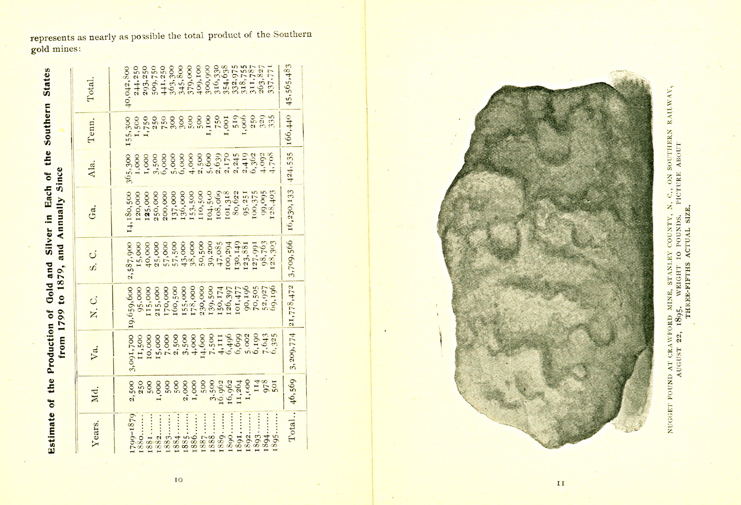
The following tabular statement shows the production of gold, by years,
for North and South Carolina and by way of comparison for other Southern
States. These figures include, besides the United States mint and assay
office receipts, all such bullion as went abroad, or was used directly by
local jewelers or otherwise, and
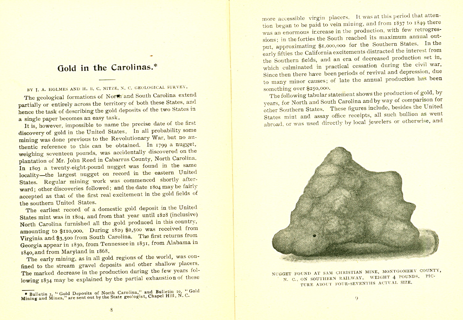
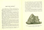
("Nugget found at Sam Christian mine, Montgomery County, N.C., on Southern
Railway. Weight 4 pounds. Picture about four-sevenths actual size.") |
|
| |
10,11 |
represents as nearly as possible the total product of the
Southern gold mines:
"Estimate of the Production of Gold and Silver in Each of the Southern
States from 1799- 1879, and Annually Since"
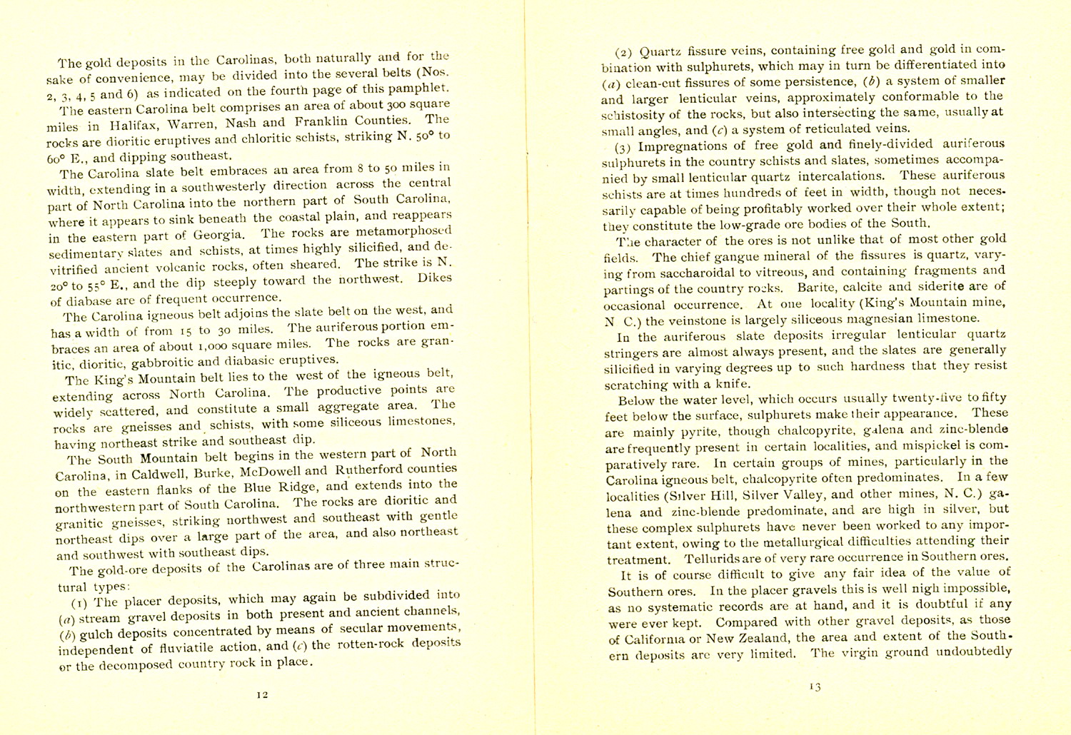
"Nugget found at Crawford Mine, Stanley County, N.C., on Southern Railway,
August 22, 1985. Weight 10 pounds. Picture about three-fifths actual
size." |
|
| |
12,13 |
The gold deposits in the Carolinas, both naturally and for
the sake of convenience, may be divided into the several belts (Nos. 2, 3,
4, 5 and 6) as indicated on the fourth page of this pamphlet.
The eastern Carolina belt comprises an area of about 300 square miles in
Halifax, Warren, Nash and Franklin Counties. The rocks are dioritic
eruptives and chloritic schists, striking N. 50 degrees to 60 degrees E.,
and dipping southeast.
The Carolina slate belt embraces an area from 8 to 50 miles in width,
extending in a southwesterly direction across the central part of North
Carolina into the northern part of South Carolina, where it appears to
sink beneath the coastal plain, and reappears in the eastern part of
Georgia. The rocks are metamorphosed sedimentary slates and schists, at
times highly silicified, and devitrified ancient volcanic rocks, often
sheared. The strike is N. 20 degrees to 55 degrees E., and the dip steeply
toward the northwest. Dikes of diabase are of frequent occurrence.
The Carolina igneous belt adjoins the slate belt on the west, and has a
width of from 15 to 30 miles. The auriferous portion embraces an area of
about 1,000 square miles. The rocks are granitic, dioritic, gabbroitic and
diabasic eruptives.
The King's Mountain belt lies to the west of the igneous belt, extending
across North Carolina. The productive points are widely scattered, and
constitute a small aggregate area. The rocks are gneisses and schists,
with some siliceous limestones, having northeast strike and southeast dip.
The South Mountain belt begins in the western part of North Carolina, in
Caldwell, Burke, McDowell and Rutherford counties on the eastern flanks of
the Blue Ridge, and extends into the northwestern part of South Carolina.
The rocks are dioritic and granitic gneisses, striking northwest and
southeast with gentle northeast dips over a large part of the area, and
also northeast and southwest with southeast dips.
The gold-ore deposits of the Carolinas are of three main structural types:
1) the place deposits, which may again be subdivided into a) stream gravel
deposits in both present and ancient channels, b) gulch deposits
concentrated by means of secular movements, independent of fluviatile
action, and c) the rotten- rock deposits or the decomposed country rock in
place.
2) Quartz fissure veins, containing free gold and gold in combination with
sulphurets, which may in turn be differentiated into a) clean-cut fissures
of some persistence, b) a system of smaller and larger lenticular veins,
approximately conformable to the schistosity of the rocks, but also
intersecting the same, usually at small angles, and c) a system of
reticulated veins.
3) Impregnations of free gold and finely-divided auiferous sulphurets in
the country schists and slates, sometimes accompanied by small lenticular
quartz intercalations. These auriferous schists are at times hundreds of
feet in width, though not necessarily capable of being profitably worked
over their whole extent; they constitute the low-grade ore bodies of the
South.
The character of the ores is not unlike that of most other gold fields.
The chief gangue mineral of the fissures ins quartz, varying from
saccharodidal to vitreous, and containing fragments and partings of the
country rocks. Barite, calcite and siderite are of occasional occurrence.
At one locality (King's Mountain mine, N.C.) the veinstone is largely
siliceous magnesian limestone.
In the auriferous slate deposits irregular lenticular quartz stringers are
almost always present, and the slates are generally silicified in varying
degrees up to such hardness that they resist scratching with a knife.
Below the water level, which occurs usually twenty-five to fifty feet
below the surface, sulphurets make their appearance. These are mainly
pyrite, though chalcopyrite, galena and zinc-blende are frequently present
in certain localities, and mispickel is comparatively rare. In certain
groups of mines, particularly in the Carolina igneous belt, chalcopyrite
often predominates. In a few localities (Silver Hill, Silver Valley, and
other mines, N.C.) galena and zinc-blende predominate, and are high in
silver, but these complex sulphurets have never been worked to any
important extent, owing to the metallurgical difficulties attending their
treatment. Tellurids are of vary rare occurrence in Southern ores.
It is of course difficult to give any fair idea of the value of Southern
ores. In the placer gravels this is well nigh impossible, as no systematic
records are at hand, and it is doubtful if any were ever kept. Compared
with other gravel deposits, as those of California or New Zealand, the
area and extent of the Southern deposits are very limited. The virgin
ground undoubtedly |
|
| |
14,15 |
yielded handsome returns, though it was imperfectly
worked, for many of the old tailings dumps have been washed over a second,
third, and even as often as a seventh time at a profit. Channels running
as high as $20 per cubic yard are recorded, but perhaps the vast majority
of the ground worked yielded between 25 cents and $1 per cubic yard.
The auriferous rotten-rock bodies found in some districts are exceedingly
variable in value. Certain small quartz stringers may run very high.
Material as low as 40 cents per ton (equal to 12 cents per ton material
mined) has been milled at a profit, but, as a rule, the grade of the
mill-stuff is somewhat higher.
It is impossible to make any reliable statements regarding the quartz
veins, the variation is so great. However, it may be said that generally
the concentrated sulphurets run from $30 to $40 per ton- i.e., after the
extraction of the free-milling portion, which may be from 20 to 50 cent of
the value of the ore. The large bodies of low-grade auriferous schists may
yield anywhere from $2 to $5 per ton in quantity.
Placer mining was the first mode of winning gold in the South, and many of
the mechanisms now used universally, such as the rocker and long tom,
originated here. At the present day very few gravel mines are in
operations. Of those that are, two classes may be named: 1) operations on
virgin deposits, 2) operations on ground that has already been worked.
On the first a good example is the Crawford mine in Stanly County, N.C.,
four miles southeast from Albemarle. It was first opened in 1892. The
gravel bed, composed of angular quartz and slate fragments in a clay
matrix, occurs in a narrow stream bottom, perhaps 250 feet in width. Its
thickness is 1 1/2 to 2 feet, and the overlay is from 2 to 4 feet deep.
Owing to the scarcity of water here, a novel method of washing is pursued.
A wooden tank, of 200 cubic yard capacity, is situated at some elevation
above the stream bed. At one end is a standpipe 30 feet high, which is
supplied with water from a reservoir below by a stream pump. The gravel is
hauled to the top of the tank in tram-cars and dumped. here it is washed
by the discharge from the stand pipe. A line of riffled sluice-boxes runs
from an opening in one side and near the bottom of the tank. The gold is
collected from the bottom of the tank, and from the riffles in the
sluices. It
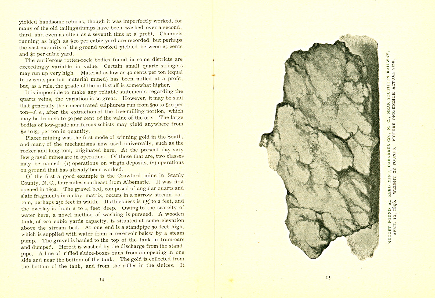
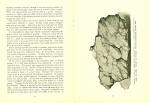
"Nugget found at Reed Mine, Cabarrus Co., N.C., near Southern Railway,
April 10, 1896. Weight 22 Pounds. Picture one-eight actual size." |
|
| |
16,17 |
occurs almost exclusively in the shape of nuggets; no
quicksilver is used. In April 1895, an 8-pound nugget was found, and in
August o the same year one weighing 20 pounds. The cost of working is
estimated at about 50 cents per loose cubic yard.
Of the second class, the Mills property at Brindletown, Burke County,
N.C., is perhaps the best example. On this and other adjoining properties
of the South Mountain region some placer deposits have been profitably
worked over three or four times at intervals of several years.
The best known and most extensively worked mining district in North
Carolina is that at Gold Hill, at the junction of Rowan, Stanly and
Cabarrus Counties. The country rock is chloritic and argillaceous schist,
with the usual northeast by southwest strike, and dipping steeply to the
northwest. For a distance of 1 1/2 miles along the strike and for a width
of about 1,,200 yards the country rock is more or less impregnated with
gold bearing pyrite, the pyrite being concentrated into more limited
belts, in which are numerous lenticlar veins and small stringers of
gold-bearing quartz.
Among the better defined of these veins are the Randolph, Barnhardt,
Honeycut, Standard, Trautman and McMackin. The first of these has been
worked to a depth of 750 feet. But little work is being done at the mine
at the present time, but it is estimated that the total yield has been
more than $3,000,000. The methods of treating the ore have at times been
so crude that 67 per cent of the gold is said to have been lost in the
tailings.
As the best example of a mine working on t a large body of low-grade slate
ore, the Haile in Lancaster County, S.C., three miles northeast of
Kershaw, is cited. The auriferous bodies are lenticular in shape, about
200 feet in length and 100 feet in maximum width. The pitch is 50 degrees
to 60 degrees N.E. and the dip 45 degrees N.W. to vertical. The ore
consists of silicified sericitic schists, impregnated with free gold and
sulphurets (pyrite from 2 to 25 per cent). The average assay value is
about $4 per ton. Diabase dikes intersect the ore bodies, and the richest
ores are usually found in their vicinity. The greatest depth of the
workings is 270 feet. The mill is a 60-stamp one, and treats 120 tons of
ore per day; about 33 per cent of the gold is free milling, and the
percentage of extraction is from 75 to 80 per cent. The concentrates from
twenty Embrey tables amount to about 8 tons per twenty-four hours, and
assay from $25 to $35 per ton. They are treated in a three-barrel Thies
chlorination plant, where the extraction averages 94 per cent. The cost of
roasting per ton of roasted concentrates is $2.58. The cost of
chlorinating per ton of roasted concentrates is $1.45. The cost of
roasting and chlorinating per ton of raw concentrates is $3.02, and per
ton of ore mined 19 cents.
The Brewer mine is, next to the Haile, the best known and most productive
of the South Carolina mines, and is located about 8 miles northeast of the
Haile, the country rock and ores resembling that of the latter mine in
many respects. The ores are low grade averaging about $3 per ton; but
there is a large quantity of this ore; and, furthermore, there are here
extensive placer deposits, the total width of the ore-bearing ground being
given as 800 yards.
It now remains to draw some general conclusions, and to present some idea
of the possible future of gold mining in the South. The above examples,
taken from the few successful mines in the field, most not be accepted as
typical. They are cited because the mines are developed, and in order to
show that what can be done. Of the great number of mines that have at one
time or another been in operation in the South but few are not working,
and still fewer productively. The causes of mining failures are numerous.
As in all other mining districts a certain number of failures but be
attributed to the incapacity of the mine itself. At the same time good
mines have been injured by speculative maneuvers and stock manipulations.
The introduction of numerous patent processes and mechanical contrivances
of unquestionable inferiority, often approaching the ridiculous, for
crushing, amalgamation and other metallurgical treatment, explains the
failure of many a mine; yet often the blame was attached, not to the
defects of the process (where it belonged), but to the ores tested. After
the true free-milling brown ores were practically worked out, many
operations were continued on the deeper sulphuretted ores, employing
simple amalgamation without attempting to recover the gold in the
sulphurets, which escaped in the tailings in enormous quantities. Again, a
very general mistake has been the erection of costly milling and other
machinery, previous to the proper opening of the mines, and without having
sufficient ore in sight to supply the works. One great drawback to
investors is the fact
|
|
| |
18,19 |
that many of the mining properties, even though entirely
undeveloped, are held by the owners at figures so unreasonable and
prohibitory as to preclude any fair deal. The sooner the folly of this is
realized the better. Capital is needed in the South to develop its mineral
resources, and mine owners must remember that the cost of an undeveloped
mine is only a part of the ultimate expense of putting it in working and
producing order.
All of these mistakes are gradually being comprehended, and the advantages
of chlorination, cyanide treatment and smelting are becoming known. The
stamp mill, very properly, is more tenaciously adhered to than ever for
crushing purposes. The economic success of the chlorination process, for
the treatment of concentrated sulphurets with an extraction of 90 to 98
per cent, has already been practically demonstrated by the excellent work
at the Haile, Franklin and other mines. It is stated that recent
experiments at the Russell mine in Montgomery County, N.C., have shown
that treatment by the cyanide process will cost from 90 cents to $1 per
ton, on a scale of 100 tons per day, with an extraction of 85 to 90 per
cent. For such mines as the Silver Hill and the Silver Valley, the complex
sulphurets (galena, zing- blende, etc.) must be treated by smelting; and
for this purpose copper ores are necessary. Suitable auriferous copper
ores do not exist in many of the mines, notably those of Guilford and
other counties of middle North Carolina. The establishment of custom
sampling works and metallurgical plants, of which not one exists in the
South today, and the reopening of mines necessary to supply them, are not
unfeasible undertakings, though they may be difficult, and will require
capital. But the advantage to the South cannot be overestimated.
Regarding placer mining, more systematic work is necessary. One of the
chief difficulties is the fact that the deposits are in many cases below
drainage; to overcome this, the more general adoption of the hydraulic
elevator is recommended.
The history of gold mining in the South would form a long chapter if it
were attempted to give in detail the manifold conditions, the rise and
fall of the numerous ventures, which have led to the present neglected
state of the industry. Suffice it to say here, that, although no bonanzas
can be expected, workable bodies of ore exist, which may form the basis of
profitable mining operations, so long as these are confined to legitimate
ends, governed by sound and capable business and technical management, and
protected from the interference of patent charlatan processes. The
treatment of low-grade sulphurets is the ultimate problem in almost every
mining camp; and so in the South these must be the main source of its gold
production. It is believed that the state of the industry is approaching a
healthier condition, and that the preparations now in progress and the
growing interest manifested in the development of the resources of the
South point to a reasonable revival of gold mining, with an increased
production, though it may be many years before it can attain even its
former maximum production.
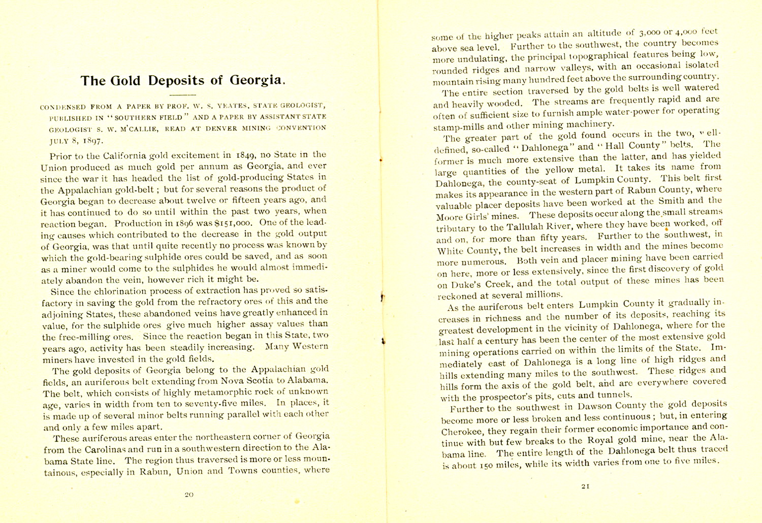
"Nugget found at Sam Christian Mine, Montgomery County,
N.C., on Southern Railway. Weight 2 pounds. Picture one-half actual size. |
|
| |
20,21 |
"The Gold Deposits of Georgia"
Condensed from a paper by Prof. W. S. Yeates, State Geologist, Published
in "Southern Field" and a paper by Assistant State Geologist S. W.
M'Callie, read at Denver Mining Convention July 8, 1897.
Prior to the California gold excitement in 1849, no State in the Union
produced as much gold per annum as Georgia, and ever since the war it has
headed the list of gold-producing states in the Appalachian gold-belt; but
for several reasons the product of Georgia began to decrease about twelve
of fifteen years ago, and it has continued to do so until within the past
two years, when reaction began. Production in 1896 was $151,000. One of
the leading causes which contributed to the decrease in the gold output of
Georgia, was that until quite recently no process was known by which the
gold-bearing sulphide ores could be saved, and as soon as a miner would
come to the sulphides he would almost immediately abandon the vein,
however rich it might be. Since the chlorination process of extraction has
proved so satisfactory in saving the gold from the refractory ores of this
and the adjoining States, these abandoned veins have greatly enhanced in
value, for the sulphide ores give much higher assay values than the
free-milling ores. Since the reaction began in this States, two years ago,
activity has been steadily increasing. Many Western miners have invested
in the gold fields. The gold deposits of Georgia belong to the Appalachian
gold fields, an auriferous belt extending from Nova Scotia to Alabama. The
belt, which consists of highly metamorphic rock of unknown age, varies in
width from ten to seventy-five miles. In places, it is made up of several
minor belts running parallel with each other and only a few miles apart.
These auriferous areas enter the northeastern corner of Georgia from the
Carolinas and run in a southwestern direction to the Alabama State line.
The region thus traversed is more or less mountainous, especially in
Rabun, Union and Towns counties, where some of the higher peaks attain an
altitude of 3,000 or 4,000 feet above sea level. Further to the southwest
the country becomes more undulating, the principal topographical features
being low, rounded ridges and narrow valleys, with an occasional isolated
mountain rising many hundred feet above the surrounding county.
The entire section traversed by the gold belts is well watered and heavily
wooded. The streams are frequently rapid and are often of sufficient size
to furnish ample water-power for operating stamp-mills and other mining
machinery.
The greater part of the gold found occurs in the two, well-defined, so
called "Dahlonega" and "Hall County" belts. The former is much more
extensive than the latter, and has yielded large quantities of the yellow
metal. It takes its name from the Dahlonega, the county- seat of Lumpkin
County. This belt first makes its appearance in the western part of Rabun
County, where valuable placer deposits have been worked at the Smith and
the Moore Girls' mines. These deposits occur along the small streams
tributary to the Tallulah River, where they have been worked, off and on,
for more than fifty years. Further to the southwest, in White County, the
belt increases in width and the mines become more numerous. Both vein and
placer mining have been carried on here, more or less extensively, since
the first discovery of gold on Duke's Creek, and the total output of these
mines has been reckoned at several millions.
As the auriferous belt enters Lumpkin County it gradually increases in
richness and the number of its deposits, reaching its greatest development
in the vicinity of Dahlonega, where for the last half a century has been
the center of the most extensive gold mining operations carried on within
the limits of the State. Immediately east of Dahlonega is a long line of
high ridges and hills extending many miles to the southwest. These ridges
and hills form the axis of the gold belt, and are everywhere covered with
the prospector's pits, cuts and tunnels.
Further to the southwest in Dawson county the gold deposits become more or
less broken and less continuous; but, in entering Cherokee, they regain
their former economic importance and continue with but few breaks to the
Royal gold mine, near the Alabama line. The entire length of the Dahlonega
belt thus traced is about 150 miles, while its width varies from one to
five miles.
|
|
| |
22,23 |
The Hall County belt, though not so important from an
economic point of view as the Dahlonega, has yielded, nevertheless, at
various points along its course, considerable quantities of gold. It lies
some ten miles east of Dahlonega belt, and runs more of less parallel with
it for nearly a hundred miles, stopping short, apparently, in Fulton
County, eight or ten miles north of Atlanta.
A third belt, including the Acworth, Villa Rica, and Bonner mines,
traverses Cobb, Paulding and Carroll counties. It reaches its greatest
development in the neighborhood of Villa Rica, where it has been
extensively worked.
Many miles to the southeast, near the limit of the Crystalline area, is
another series of mines, which may be grouped, geographically, into a
fourth division (appearing to be the southern extension of a well known
South Carolina belt), traverses Lincoln, Columbia, McDuffie and Warren
counties.
Beyond the limits of the above-named occurrences are to be found numerous
isolated localities, where gold is mined in paying quantities. Such
deposits are found in Towns, Union, Fannin, Gilmer, Meriwether and other
counties in North Georgia. They consist of both vein and placer deposits,
and frequently surpass in richness the mines located on the main belts.
Besides the deposits of economic extent, there are still others of less
importance in nearly every county within the Crystalline area. In fact, it
is commonly stated, and can probably be verified, that all the streams of
North Georgia, with few exceptions, carry more or less gold.
The individual auriferous belts are generally made up of several veins of
ore bodies, running more or less parallel with each other, and conforming
in dip and strike to the country rock. They vary in thickness from the
fraction of an inch to a number of yards, and can often be followed along
their outcropping for considerable distances. One of the most typical
veins may be described as a series of ore shoots or chimneys united by
quartz stringers. Another commonly met with consists of thin layers of
quartz interlaminated with schists, having the general appearance of a
stratified deposit. A third, called the "blanket deposit," is made up of
numerous lens-shaped layers of quartz, imbedded in schists or gneisses.
All these varieties of ore deposits sometimes occur in the same locality,
as in the Dahlonega region; but, as a general rule, the deposits of each
district are similar or pass gradually from one to the other.
Dahlonega, the county-seat of Lumpkin County, is the most important
gold-mining town in Georgia. In 1838 a United States mint was located in
Dahlonega, and active operations were continued until the breaking out of
the war in 1861. During the twenty-three years in which the mint was
operated at Dahlonega $6,106,569 was coined, principally in half eagles
and quarter eagles, the greatest amount coined in any single year being
$582,782.50, in 1843. It has been estimated that fully as much of the gold
mined in Georgia found its way into the markets by other channels as was
coined at the mint.
There are now in operation in the county twelve stamp mills, with a total
of 240 stamps. In addition to these, a Huntington mill is operated at the
Betz mine.
Many of the saprolitic hydromica slates are gold-bearing. All these states
carry auriferous quartz veins, varying in size from an eighth of an inch
to several feet in width. The ores are free-milling until water-level is
reached, many of the veins showing free gold. At water-level the ore
changes to auriferous sulphides, usually pyrite (iron sulphide), though
galena and chalcopyrite are of frequent occurrence.
White County, which adjoins Lumpkin on the east, in the same belt, is one
of the most noted in the State for its rich placer mines. Like Lumpkin,
the most of these have been worked over by the old crude methods of placer
mining employed about the middle of this century, though considerable
virgin material is still left. Before the war, and even sine, these
placers produced many handsome nuggets of gold.
There are a number of good mines in Cherokee County, including the famous
Franklin or Creighton mine. This mine is between 400 and 500 feet deep.
Its ore consists of auriferous pyrite in quartz. Mrs. Franklin, a widow,
who first owned the mine, began working it in 1840. After the sulphide ore
was reached, her successors, in operating it, hard poor results. When it
feel into the hands of the Creighton Mining Company, they equipped the
mine with the necessary outfit for the cyanide process of extraction. This
was an improvement on the old amalgamation process, but still it was
unsatisfactory, as a large amount of the assay value of the ore was not
saved; so the company substituted, for the cyanide, the Thies barrel
chlorination process, which has given highly satisfactory results. |
|
| |
24,25 |
In Dawson County the Kin Mori mines were opened years ago.
In 1883 a supply ditch 33 miles long was constructed, and placer mining
was begun. In 1884-'85 a 30-stamp mill was erected and hydraulic ore
mining was begun, on the saprolitic slates and vein content, of what is
locally known as the Quarles belt. Riffles were used in the flume between
the mine and the mill, and considerable of the gold was caught before
reaching the mill. Operations of this character were continued till the
early part of 1888. During the working of the ore body, about 300,000
cubic yards were worked at an estimated expense of one cent per cubic
yard, and about fifty cents per ton for milling. No attempts were made to
save the gold from the sulphides, which were allowed to go off with the
tailings, and it is highly probably that by far the larger part of the
gold was lost in this way. One large vein near the mill, known as the "Big
Sulphuret" vein, has yielded, on assay, as high as $23.40 per ton. It is
said that one ton of crude sulphides can be concentrated from twenty-five
tons of the ore. There is every reason to believe that the addition of a
roasting and chlorinating plant will make the mining of this property
profitable. Other properties in this vicinity would justify further
prospecting.
In Rabun County considerable placer mining was done, in the northeastern
part of the county, between 1835 and 1849, with very satisfactory results;
but no veins have ever been located in this part of the county.
In Carroll and Haralson Counties great activity has sprung up within the
last year at Villa Rica and Tallapoosa, respectively, both of which are on
the Birmingham Division of the Southern Railway. At the old Clopton mine,
which was purchased last year by a Boston company with a capital of
$300,000, work is being carried on. These shafts have been sunk about 200
feet. About a mile from Villa Rica a s tock company is working off the
saprolite by hydraulic mining, with the view to exposing a gold-breaking
vein which at six feet deep is twenty feet side. Picked samples are said
to have assayed as high as $250 a ton.
[In this district systematic prospecting work has been commenced at four
properties not before mentioned. These are on lot 193 by Mr. Weimland for
a Chicago syndicate; on an adjoining property by Mr. Roach for some of the
stockholders of the Ducktown Copper and Sulphur Company, of Tennessee,
and by Mr. Rainey at the old Hart mines for a Wisconsin syndicate. At
another point about four miles southerly from the town of villa Rica, a
St. Louis syndicate is prospecting on the Cobb farm and milling a limited
quantity of material from near the surface, consisting of the decomposed
formation and quartz taken from a shaft about 30 feet deep at the head of
a trough which has been worked by placer miners years ago. The mill is of
a new pattern made in St. Louis and constructed without any device for
amalgamating except on a stationary plate. The crushing is done by a
series of small hammers which revolve on a horizontal shaft, encased in a
casting, the entire machine occupying a space of some six cubic feet. The
crushed material drops on a screen, through which the finer pulp passes,
while the coarser is discharged as waste. From the screen the finer pulp
passes over mercurialized electro plated copper plates, thence to sluice
boxes.
Work is being prosecuted at the Mineral Farm mine, the shaft having been
carried down about 146 feet. At this point it is proposed to crosscut the
ore body, and it is the purpose to install machinery for air drills to run
the crosscutting and drifting. This ore is a pyrrohite and iron pyrites,
the value of which, either in copper or gold, I am not informed. The walls
are apparently an altered eruptive rock and the gangue quartz.
Near Bremen, about 10 miles west from Villa Rica, some shallow prospecting
has been done in a formation very similar to that at the Mineral Farm
mine. A body of iron pyrites and pyrrhotite has been cut in two or three
places, and I am informed some samples assayed as high as 9 per cent
copper.--W.M. Brewer.]
In Haralson County the old Camille mine near Tallapoosa, now known as the
Royal mine, is being worked with modern machinery and methods by the Royal
Mining Company. The ore is both free=milling and refractory. It is said
that assay tests show an average value of $17.90 per ton, but that one of
the veins, very rich in auriferous pyrite (gold-bearing iron sulphide),
assays as high as $158 per ton. The ore body varies in thickness from six
to twenty feet or even more. The assays vary from very low to very high.
The length of the slope in the mine is 186 feet, drifts 450, depth of
shafts 144. In the mill are 40 new 850-pound stamps, with |
|
| |
26,27 |
Challenge feeders ad 12 true vanners, a 5-foot Huntington
mill with plates and concentrators. The ore to the mill runs about $6.
Other mines are being opened up or prospected in this vicinity.
In the Hall County belt the Currahee mine near Gainesville is the best
developed. The ore is white quartz, containing large proportions of
auriferous pyrite and galena, though it is said to be of low grade. The
ore bodies are so extensive and easy of access that large quantities of it
may be handled at comparatively small cost.
On the Dahlonega belt in Forsyth County, properties are rich in sulphides.
Five veins cut the Littlefield property, one, at least, being free milling
for a depth of thirty-seven feet, as deep as the shafts were sunk. Besides
the veins, there is a small placer on the property, which is being worked
by tributers.
The part of the Hall County gold belt lying in Gwinnett County, so far as
known, is alongside the Southern Railway between Suwannee and Buford. The
vein at the Piedmont mine, two miles west of Buford, is a fissure, cutting
the slates at a side angle. The ore body consists of compact white quartz,
containing varying proportions of pyrite, galena, and free gold. Assays,
made for the company, from both average and picked samples, range from $5
to $31 per ton; and it is probably that work was stopped because of the
inability of the miner to extract the gold from the sulphides.
Considerable free gold in thin leaves is found in the Wilkes mine,
Meriwether County. A shaft, thirty feet deep, has been sunk on the vein,
which is in decomposed gneiss. It is said that considerable of this
decomposed gneiss is gold-bearing.
At the Walker, in McDuffie County, has been mined, with great success, a
hard quartz ore, containing free gold and auriferous sulphides, using
nothing but a five-stamp mill with copper plates coated with mercury to
save the gold, the sulphides going off with the tailings into the river. A
chlorination plant, in connection with the mill, would most likely result
in saving twice as much gold as is now saved. The mine is about 200 feet
deep. The vein of hard white quartz, containing pyrite, chalcopyrite and
galena, with now and then free gold, varies from eighteen to thirty-six
inches in width, averaging, probably, thirty inches. It strikes northeast
and southwest and is almost vertical, dipping slightly to the south-east.
This is an illustration of what deep mining may be expected to do, in
other parts of the State, when it shall be undertaken. The fact is that in
most parts of the State the mining of the soft, decomposed slates, with
their included veins, is done at so small an expense that when the hard
refractory ores are reached another cut is begun in some other part of the
saprolite, rather than go to the expense of putting up a plant for saving
the refractory ores, which are invariably richer, ton for ton, than the
saprolite.
"Gold Mining in Alabama"
By Eugene A. Smith, State Geologist.
The Crystalline schists which carry the gold-bearing rocks of Alabama,
occupy a triangular-shaped area of some 4,500 square miles near the
eastern border of the State. These schists are the metamorphosed
representatives of both sedimentary and igneous rocks, those are the
former origin preponderating in the northwestern part of the area, and
those of igneous origin making up the great bulk of the rocks of the
southeastern part. The auriferous veins are associated in the great
majority of cases with altered sedimentary rocks, which are as a rule
feebly crystalline slates, formerly considered and designated as talcose
slates, although true talcose slates are comparatively rare among our
metamorphic rocks. In many places the slates of the kind above named
contain a large proportion of disseminated graphite, as in the case at the
blue Hill and Gregory Hill mines in Tallapoosa County.
Another class of altered sedimentary rocks is represented by |
|
| |
28,29 |
mica schists and mica gneisses, likewise in nearly all
cases carrying a very considerable percentage of graphite.
The gold bearing veins of Alabama show approximate conformity with the
wall rocks, and for this reason they have often been described as bedded
veins and veins of segregation. The investigations of Prof. Becker in the
Southern Appalachians have shown that the structure with which the
deposits are conformable is not stratification but schistose cleavage, and
this cleavage he also shows to have been produced prior to the movements
which opened the fissures, and further, the pressures which opened the
vein fissures did not in general coincide in direction with those which
had previously produced schistosity. The result of the dislocation was to
produce lens-like openings along the main cleavage of the rocks, which
were subsequently filled with quartz, forming what he terms lenticular
stringers. These stringers are often discontinuous, one dwindling away of
disappearing, while its place is taken by another in the foot or hanging
wall. In many instances diagonal seams may be seen to connect such
imbricating stringers, and where the connection cannot be actually seen it
is nevertheless inferred to exist, and the conclusion is reached that all
the stringers were once united by cracks sufficiently large to permit the
passage of solutions. Such connected groups of veins have been termed by
Prof. Becker "linked veins," and the association of small fissures, each
bearing a lenticular mass of quartz, he calls a stringer lead.
While the greater part of the Alabama gold deposits corresponds to the
stringer lead type, yet there are numerous small cross fissures, some of
which are quite rich in gold.
The stringer leads coincide in general with the schistose structure of the
country, yet they do not coincide with this structure in detail, and they
may therefore be classes as true veins, i.e., in the fillings of
pre-existing cavities. Instances are also numerous where the veins are
attended with impregnations of the country rock to such a degree that the
latter is mined and milled for gold along with the material of the veins
themselves.
It has not as yet been possible to discover the connection existing
between the ore deposits and the dikes of igneous rock, nor can it be said
that a satisfactory explanation of the origin of the gold has yet been
reached.
The loose materials which carry the gold in Alabama, as well as in the
other Southern States as shown by Prof. Becker, are of two kinds, viz: the
ordinary stream gravels and the accumulation of rotten rock in place. To
this latter, Prof. Becker proposes the name saprolite as a general
term descriptive of thoroughly decomposed, earthy, but untransported rock.
Prior to 1849 a vast amount of work was done in Alabama in numerous
localities in Tallapoosa, Chilton, Coosa, Clay, Cleburne and Randolph
Counties, in working over the placer deposits and the quartz veins in the
decomposed slates. This kind of work was kept up with somewhat less vigor
after the breaking out of the California gold fever, until the beginning
of the civil war in 1860. Since the war, while stamp mills have been in
operation at Pinetucky mine in Randolph County, more of less continuously
for twenty-five of thirty years, and fitfully at other points, practically
very little has been done in Alabama in the way of the systematic milling
of gold quartz until recently, when the success of Capt. Thiess in South
Carolina has amply demonstrated the practicability of the profitable
extraction of gold from the low-grade ores which so greatly predominate in
the Southern Appalachians. The last six or eight years have witnessed a
great revival of interest in the gold regions of this section, and the
resources of several of the States have been pretty thoroughly
investigated. Since 1892 the Alabama Geological Survey has been engaged in
the investigation of the gold fields of the State with the result of
showing that there are several localities in Tallapoosa, Clay, Cleburne
and Randolph Counties where there is a sufficient quantity of low-grade
ore to justify the erection of milling plants. Bulletins Nos. 3 and 5 of
this survey contain reasonably full descriptions of the main occurrences
of gold ores in the State, but special note may here be taken of the
following"
Tallapoosa County.-In the Silver Hill district the work has been going on
with little interruption for a number of years. The quartz veins are
associated with graphitic schists, and the mining and milling can be
carried on at very little cost. Further north in the Goldville district, a
good deal of work has recently been done in opening up the old Ulrichs
property, and a good quantity |
|
| |
30,31 |
of machinery has been placed, with a view to active mining
work immediately. At Hog Mountain a large number of heavy views of
gold-bearing quartz have been exposed and tested in a systematic manner by
Mr. Aldrich. This prospecting work has been going on for several years,
and active work in mining and milling will undoubtedly soon begin. This is
one of the most promising gold properties of the State.
Clay County.-In the Goldberg district, a milling plant with Cawford mills
has recently been erected, but up to date not much work has been done
there. In the Idaho district Mr. Joshua Franklin has for more than a year
been running with profit a Huntingdon mill, using the low-grade ores of
that vicinity. He has in this time fully demonstrated the fact that these
low-grade, free-milling ores can be economically treated. Near the
Franklin mine, another establishment, under the direction of Dr. Wm. B.
Phillips, is making a test on a commercial scale of ores of similar grade
to those of Franklin mine. I have very little doubt that the result of
these tests will be satisfactory.
Randolph County.-The Pinetucky is the only mine now in active operation in
the county. A ten-stamp Fraser and Galmers mill is here used. As above
indicated this is one of the oldest mines in the State.
Cleburne County.- At Arbacoochee placer work has been carried on more
extensively than in any part of the State, except possibly in the vicinity
of Goldville in Tallapoosa County. At the present time very little is
being done in either district. The Chattanooga Mining Company is doing
some work, and have recently gotten out a number of fine nuggets along
with the fine gold. A few years ago an exceedingly rich vein of quartz
carrying free gold was exposed in a shallow shaft at Arbacoochee, but
litigation has put a stop to further developments there. To the eastward
of Arbacoochee, in Tricken Valley, there is also much activity, especially
in the line of development. At the Hicks-Wise shaft, at a depth of 150
feet, ore of fairly good grade is still found. The width of the ore body
at the surface is about 30 feet.
Up to this date no plant has been introduced into Alabama by which the
sulphurets can be utilized, all our works being adapted to the
free-milling surface ores alone. Now that the experience of the past three
years has shown that we have at several points a sufficient quantity of
low-grade ore to justify the erection of mills, it will follow naturally
that when the surface ores are exhausted arrangements will me made to turn
to account the refractory sulphurets.
To sum up the situation in Alabama, we have amply demonstrated the fact
that low-grade ores in sufficient quantity occur at several places within
the gold belt. At the Franklin mine, in the Idaho district, an experiment
extending over more than a year has shown that these low-grade ores can be
worked with profit with a Huntingdon mill and a stamp mill. The experience
at the Pinetucky mine, extending over a period of more than twenty years,
has been somewhat similar, though the character and mode of occurrence of
the ore are quite different from what obtains at the Franklin mine.
"Tennessee Gold"
The gold deposits in Tennessee are not so extensive as in
other Southern States, but there are several mines which have been worked
off and on, and in which much the same formation is found as in most of
the gold-bearing belts in North Carolina. Modern methods of mining would
probably show the deposits formerly worked to be sufficiently rich to give
a good profit. The United States Geological Survey has the following list
of locations in Tennessee counties, which lie on the western slope of the
Great Smoky Mountains and on the North Carolina border:
Coca Creek, Monroe County, Whippoorwill Mining Company, gold-bearing
quartz vein in semi-talcose clay slate; Coca Creek, Monroe County, in
sandstone gravels, worked a little every year; east of Montvale Springs,
Blount County; in water of Citico Creek, Monroe County; in bed of Cane
Creek, Monroe County; Polk County also; veins of gold-bearing quartz in
Ocoee group of slates. |
|
| |
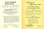
32, Back Inside Cover |
"Southern Railway
Penetrating all the States of the South
Irreproachable Service schedules unequaled"
"Pullman Drawing-Room Sleeping Cars
Between New York, Washington and Atlanta; New Orleans, Birmingham,
Memphis, Asheville, Hot Springs, Knoxville, Chattanooga and Nashville;
Savannah, Jacksonville and Tampa."
"The Southern Railway is the Great highway of the Southern States"
|
 |