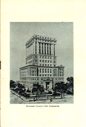
| 13 |
bcch013 |
A Brief History of Buncombe
County by F.A. Sondley, L.L.D.
"Excerpts from a paper prepared for the ceremony of the laying of the
coner-stone for the New Court-House, November 7th, 1927.
It is well established that the Spanish exploration under Hernando
DeSoto in 1540 passed through Western North Carolina and through Buncombe
County. For years thereafter Spaniards conducted large mining operations
at various places in what is now called Western North Carolina. They made
no permanent settlement there.
The English claimed the country because of the discovery of North
America in 1497 by John and Sebastian Cabot. The British King Charles I,
in 1631 granted to Sir Robert Heath a vast territory in which was
included all North Carolina except a narrow strip along its northern
border. Little or nothing resulted from this grant. In 1663 the British
monarch Charles II, made a grant to Edward Earl of Clarendon; George, Duke
of Albermarle; William, Earl of Craven; John, Lord Berkley; Anthony, Lord
Ashley; Sir George Carteret; Sir John Colleton; and Sir William Berkeley,
know as the Lords Proprietors, conveying to them a large scope of country,
in which was included all North Carolina except a narrow strip immediately
south of Virginia. This same monarch in 1665 made to these Lords
Proprietors a second grant by which he greatly enlarged their holdings on
the south and added to them on the north so as to embrace all of North
Carolina. From these two grants to the Lords Proprietors North Carolina
arose.
BUNCOMBE COUNTY'S PEDIGREE
The Lords Proprietors soon laid off their lands into counties. The
"first Government or County was that of Clarendon County on the Cape Fear
River so called from the Earl of that title first mentioned in the
Charter." In 1729 this County of Clarendon embraced within its borders the
County of Buncombe. At that time the County of New Hanover, with
indefinite western limits which seem to have extended to the Pacific
Ocean, then called the South Sea; was formed, and the name of Clarendon as
a county disappeared. From New Hanover in 1738 was cut off the County of
Bladen whose western limits were not defined. From the County of Bladen
was formed in 1749 the county of Anson, and its western border was not
prescribed. Here Buncombe's genealogy branches in two prongs, to be united
again in her own creation.
That portion of her original territory which was taken from Burke
County is traced as follows: In 1758 Rowan County was formed from a part
of Anson County and continued in its entirety up to the Revolutionary War;
but in 1777 was formed from its western extension a county called Burke
from a governor of North Carolina.
That portion of Buncombe's original territory which was taken from
Rutherford County is traced as follows: In 1762 was formed from the
western part of the County of Anson a county named Mecklenburg in honor of
the new English Queen Charlotte of Mecklenburg in 1768 from the western
part of Mecklenburg was erected a county called Tryon in honor of the
royal Governor Tryon of North Carolina; but in 1779, while the
Revolutionary War was in progress, the name of Tryon for a county was
dropped .... |
 |
| 14 |
bcch014 |
A Brief History of Buncombe
County, cont.
... and that county was divided into two counties, one on the east
called Lincoln and the other on the west called Rutherford, in honor of
General Griffith Rutherford.
In 1792, while David Vance from the upper Reems Creek settlement was
member of the legislature from Burke County, and Colonel William Davidson,
who lived on the south side of Swannanoa River about one-fourth of a mile
below Biltmore, was a member of the legislature from Rutherford County,
the County of Buncombe was created from the western ends of Burke and
Rutherford Counties and named in honor of Colonel Edward Buncombe of
eastern North Carolina, who received the wound which led to his death at
the Battle of Germantown while fighting on the American side in the
Revolutionary War. The western and southern boundaries of Buncombe County
were then made the territory which is the State of Tennessee and the
States of Georgia and South Carolina as they now are.
In 1842 was formed from the counties of Burke and Rutherford a new
county by the name of McDowell; and, under an act of the legislature
passed in 1925 that section of McDowell County known as Broad River
Township became a part of Buncombe County.
In the meanwhile, Buncombe County has lost most of the area of its
original creation. In 1808 that part of the original territory which lies
west of its present western border became the new County of Haywood; in
1828 the western part of Macon County became the new County of Cherokee;
in 1861 the southeastern corner of Cherokee County became the new County
of Clay; in 1853 parts of Haywood and Macon County became the new County
of Cherokee; in 1861 the southeastern corner of Cherokee County became the
new County of Clay; in 1853 parts of Haywood and Macon Counties became the
new County of Jackson; in 1870-1871 parts of Macon and Jackson Counties
became the new County of Swain; in 1871-1872 a part of Cherokee County
became the new County of Graham. In 1833 Yancey County was formed from
parts of Burke and Buncombe Counties. In 1850 Madison County was formed
from parts of Buncombe and Yancey Counties. In 1838 Henderson County was
formed from the southern end of Buncombe County; and in 1851 another part
of Buncombe County was added to Henderson County. In 1861 Transylvania
County was formed from parts of Henderson and Jackson Counties. Thus
eleven counties of North Carolina have for their territories lands which
were embraced in the original County of Buncombe, the present Yancey
County territory and that territory taken from Yancey County in making
Madison County both being parts of territory taken from Buncombe County in
forming Yancey County.
COURT HOUSES
When the legislature created the County of Buncombe it appointed a
committee of six members to determine the location of the County Seat,
three from the country south of Swannanoa River and three from the country
north of that stream. Each set of committeemen wished to have the
county-town on its side of the river. They disagreed and the next
legislature substituted a new committee for the work, of the same number
from each side of the river, but, in order to insure a decision, added the
committee William Morrison from Burke County. The report of the committee
which placed the location north of the river was signed only by the
committeemen who lived north of that stream and William Morrison. The
delay thus caused in locating the county-town was the reason for the
County Court's meeting so long at the residence of Colonel William
Davidson. |
 |
| 15 |
bcch015 |
A Brief History of Buncombe
County, cont.
The first court house of the county was a log structure built across
the head of Patton Avenue at the place where that avenue entered Main
Street or the Public Square. At that court house was held the first court
which met in what is now Asheville.
The land of Samuel Chunn and Zebulon Baird on which this court house
was constructed was that part of the Public Square immediately in front of
the Thomas Building on the western side of the Public Square and the
southern side of Patton Avenue at the corner, and the land of James
Brittain and Andrew Erwin spoken of was that part of the Public Square in
front of the Adhwville Library and a little to the north. In April, 1805,
it was "Ordered by court (that) John Strother, John Stephenson, Samuel
Murray, Senr., Joseph Henry, and Thomas Foster, Senr., be appointed
commissioners for the purpose of procuring a public square, from the lot,
or land holders in the town of Asheville, most convenient and interesting
to the public, and least injurious to individuals, that the nature of the
Case will admit of "Who are to meet the 2d Saturday of July."
On January 23, 1807, deeds were made to "the Commissioners, Samuel
Murray, Enr., Thomas Foster, Jacob Byler, Thomas Love and James Brittain
appointed by the General Assembly of the State aforesaid to purchase or
secure by donation lands sufficient for a Public Square in the Town of
Asheville, in the County and State aforesaid, as follows:
By D. Vance, for $10, part of lot 30, Rec. Book A 231.
By John Patton, for $20, part of lot 13, Rec. Book A. 233.
By Zebulon and Bedent Baird, for $60, parts of lots 13 and 40, Rec. Book
A 234.
By Samuel Chunn, for $35, parts of lots 13 and 39, Rec. Book A. 237.
By Andrew Erwin (Asignee of Jeremiah Cleveland), for 1 cnet, part of lot
12, Rec. Book A, 239.
By J. Patton, Jr. for Patton and Erwin, "for the good will and respect
we bear towrds the County of Buncombe, the town of Asheville aforesaid
and the public in general," part of lot 14, 15, and 29, Rec. Book A,
523.
What is said here about the Court House renders it probable that it was
not the original log structure but a more commodious building. Later its
place was taken by a brick house built between 1825 and 1833 in the
erection of which John Woodfin, at a later time Chairman of the County
Court, had control and his son, the late N.W. Woodfin, then a boy, carried
mortar and bricks. This last gave way to a handsome brick building which
was erected from bricks of the burned house on the part of the Public
Square now occupied by the fountain, the burned building having stood
where the Vance Monument is now. The contractor for building the small
one-story brick house just mentioned was the late B.H. Merrimon.
In 1876 this small one-story house was replace by a pretentious brick
house which occupied its site made of bricks burned at the eastern end of
Clayton Street; and of it J.A. Tennent was the architect and H.W. Scott
the contractor. Then, in 1903 the present brick courthouse was built on
the southern side of College Street while M.L.Reed was chairman of the
County Commissioners. Kenneth McDonald was its architect and it was placed
upon land conveyed to the County on certain conditions by the late George
W. Pack for a county Court House."
|
 |


