The Indian Path in Buncombe County
|
|
|
|
|
| Title | The Indian Path in Buncombe County |
| Creator | Dr. Gail [Gaillard] Tennent |
| Identifier |
http://toto.lib.unca.edu/findingaids/books/booklets/indian_path_buncombe/ default_indian_path.htm |
| Subject Keyword : |
Dr. Gaillard Tennent ; Buncombe County, North Carolina ; Indians ; Cherokee ; Carolina Mountain Club ; trails ; Indian trails ; Indian paths ; Hominy Valley ; Dr. F.A. Sondley ; General Griffith Rutherford ; Biltmore Estate ; Brevard Road ; Sulpher Springs ; Sand Hill Road ; Ragsdale Creek ; Robert Henry ; Becky Poston's Tavern ; Oak Forest Church ; Hominy Creek ; Enka Road ; Captain William Moore ; David Gudger ; buffalo |
| Subject LCSH : |
Tennent, Gaillard S. (d. 1953) Indian trails -- United States Indian trails -- North Carolina Indians of North America -- North Carolina Buncombe County (N.C.) -- Description and travel Buncombe County (N.C.) -- History Indian trails -- Southern States |
| Description | A small 6 page booklet that describes the path taken by early Native Americans through Buncombe County, North Carolina from the time of the Spanish Conquistadors to the establishment of the city of Asheville, N.C.. |
| Publisher | Publisher: Stephens Press, Asheville, N.C., n.d. [after 1950 ?] ; Digital: D.H. Ramsey Library, Special Collections, University of North Carolina at Asheville 28804 |
| Contributor | |
| Date original | after 1950 |
| Date digtial | 2002-12-02 |
| Type | Text ; Map |
| Format | A 9.5" x 6.25", 6 p. booklet, privately printed |
| Source | F262 .B94 T4 ; 2nd copy in Carolina Mountain Club Archive misc. publications. |
| Language | English |
| Relation | Carolina Mountain Club Archive, D.H. Ramsey Library, UNCA ; |
| Coverage temporal | 1400's to 1800's. |
| Rights | No restrictions. Any display, publication, or public use must credit the D.H. Ramsey Library, Special Collections, University of North Carolina at Asheville. Copyright retained by the creators of certain items in the collection, or their descendents, as stipulated by United States copyright law. |
| Donor | n/a |
| Acquisition | n/a ;2002-12-13 [CMC copy] |
| Citation | "The Indian Path in Buncombe County," D.H. Ramsey Library, Special Collections, University of North Carolina at Asheville 28804. |
| Processed by | Special Collections staff, 2006. |
|
The Indian Path in
Buncombe County by Gail [Gaillard] S. Tennent |
|||
| Page [unpagi-nated] |
Image No. | Description | Thumbnail |
| ind001 [front cover] |
THE INDIAN PATH IN BUNCOMBE COUNTY By Dr. Gail Tennent [Gaillard S. Tennent] |
|
|
| ind002 |
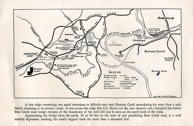
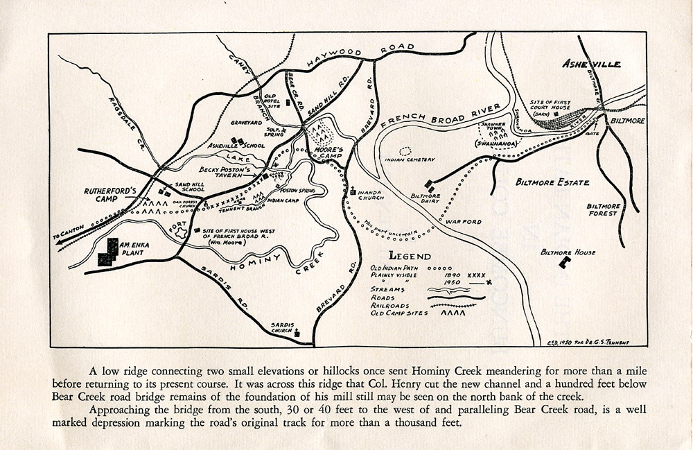
"A low ridge connecting two small elevations or hillocks once
sent Hominy Creek meandering for more than a mile before
returning to its present course. It was across this ridge that
Col. Henry cut the new channel and a hundred feet below Bear
Creek road bridge remains of the foundation of his mill still
may be seen on the north bank of the creek.
|
 |
|
| ind003 |
The INDIAN PATH By DR. GAIL TENNENT A band of white men, maybe two or three, maybe a half dozen or more, young, intrepid and fired with the urge to see what lay beyond the far "horizons, stood at the point where our present highway crosses the divide at Swannanoa Gap. It was early in the seventeenth century and a century had passed — three generations— since the Spanish gold seekers had penetrated some parts of the wilderness that lay before them, leaving only a mine shaft or two and vague descriptions of their wanderings. These young men were the first of our Nordic race to glimpse the soft-loveliness of the hazy mountains and taste the sprightly tang in the air of the highlands. This is only fantasy and yet among the restless youth of the early Virginia settlements, many of them restive under the bond of indenture to labor and most of them itching for adventure, reason indicates that some should slip away and press forward into the . unknown. To do this was far easier than it seems. We are accustomed to think of bands of early explorers hacking their way through a trackless wilderness. It was by no means thus that they traveled, for the Bureau of American Ethnology Reports state that apparently from remote times what is now North Carolina was traversed by an east and west highway. A highway as adequate to the needs of the time as the broad band of concrete that now passes through the gap is to our needs It must be remembered that even in the England they had left most of the travel was on foot or on horseback over roads little if any better than this highway.
What did this band see as they rested there in the gap and what manner of land did they enter upon?
In answering this question we leave the realm of fancy and enter that of real facts, substituting for our band of thrill seekers a small party of authentic explorers.
Dr. F. A. Sondley in his history of Buncombe County states that in 1673 General Abraham Wood in command of Port Henry, now Petersburg, in the Virginia settlements, sent two white men, James Need-ham and Gabriel Arthur with some Cherokee Indians, who had visited at the fort, to explore the mountain country. From the description of the country given after their return it was his (Sondley's) opinion that the crossing was made, at Hickory Nut Gap rather than at the Swannanoa. in any event these were the first white men of record to look upon our county of Buncombe. The fact that a party of Cherokee Indians had traveled upward of 400 miles to the Virginia settlements indicates a route by which men were accustomed to travel. During his stay with the Indians Gabriel Arthur traveled with his hosts once to Fort Royal, S. C.. and once to the mouth of the Kanawa River and down to Portsmouth, Ohio, making 1600 miles in five months. The highways must have been well known and good.
The nature of the landscape that met their eyes was not a dense virgin forest: it was rather that of the "Oak Openings" of the Fenimore Cooper period. Where the bottom lands were extensive as along the Swannanoa, lower Cane Creek, Mills River and especially along the upper French Broad, there were prairies, large for a mountain country and, wherever the terrain was low, rolling hills as in West Asheville and most of the Hominy Valley. It resembled the Kentucky scene: open pasture - nice stretches with only the steeper and rougher hills supporting heavy stands of oak. Chestnuts, black walnuts and butternuts formed a substantial part of the Indians' food and it was only in the openings that these trees bore heavy crops.
The writer well remembers the woods of Hominy Valley where the stumps, only then beginning to decay after the first onslaugh [sic] of the sawmills, marked the nature of the original forest. Only in small areas the stumps of centenarian trees denoted the venerable age of ancestral oaks with here and there standing a veteran of two or three hundred years too rugged and heavy for the appetite of the one-horse sawmills. |
|
|
| ind004 |
The "Indian Path" that is the object of this study crossed from the east into the present Buncombe County at Swannanoa Gap. According to an article by Myer in the 42nd annual Report of the American Bureau of Ethnology, it was the western end of the only ancient route that crossed the state from east to west beginning at the coast. In his introduction to the report he gives only a single paragraph to the origin of this and other paths, stating that all over America these paths had existed from prehistoric times, having been made and kept open by the larger animals in their passage from one feeding ground to another. John Arthur in his "History of Western North Carolina" quotes Bishop Spangenburg's diary that in early settlement days the only roads were buffalo trails. To cite only one of the numerous references to the presence of buffalo in our state, Audubon, in his Quadrupeds of North America, states that they had been killed as far to the east as the Cape Fear River, indeed, a buffalo bull was killed at Bull Gap only nine miles northeast of Asheville in 1815. In former times, in herds small in comparison with those of their kin on the western plains, they roamed from one to another of the larger pastures where they could hide themselves in the cane-brakes and thickets; thus keeping open the paths. The main part of our present city was within the edge of the region of rough forested hills and mountains that extended with few small openings to the East Tennessee Valley, so the path of our study by-passed it. For a detailed description of the course of the path through Buncombe County we will quote from the same article in the 42nd volume of the Ethnology reports under the caption of "Rutherford's "War Trace":
"On September 1st. 1776 the army of North Carolina, 2.400
strong, under
General Griffith Rutherford crossed the Blue Ridge at Swannanoa
Gap following the main trail almost along the present line of
the railway down the Swannanoa to its
junction with the French
Broad, crossing the latter at Warrior Ford , . . thence
up Hominy Creek and across the ridge to Pigeon river
... a few miles below
the junction of the E and W forks, thence to Richland Creek . .
. until they came to the first Cherokee town, Stekoa." [Stecoa] just
above Whittier. It is our object to focus attention on our own
portion of the path that
lies between Biltmore and
Enka. Beginning at the old entrance gate to Biltmore Estate, the route closely follows that of the Approach Road. The point where this road enters the large meadow is on the south side and across the Swannanoa River from the site of the Davidson barn. Here the first Buncombe County Court was held. The meadow itself marks the location of the only Indian town known to have been in the county, and this was the town of the Shawnees in their first stay in our Carolina Mountains after taking over the Cherokee hunting grounds. Rutherford it is supposed was the first one to give it the name "Swannanoa."
Following the Approach
Road
route a
short distance it turned S. W. along the present road to the
Biltmore Dairy as far as the gap in the hills where it turned
somewhat southward to the "War Ford" of the French Broad.
From this point to
the junction of the present Brevard Road with the Bear Creek
Road the route is
uncertain, but it follows approximately the latter road
to the Hominy bridge. Two or three hundred yards before
reaching the bridge a field lies to the west of the road and
through the dense growth of locusts on this flat the original
route of the Bear Creek Road may be seen paralleling the present
one which probably displaced the older
one
when
Henry's mill was
built. A little
hill
rises to the
southeast of the bridge and this little hill and the bottom
surrounding it are of great historic interest. Early in the 19th
century William Henry, son
of Robert Henry of Kings Mountain fame, built a mill
where Caney Creek joins
Hominy and cut a new
channel for the latter creek. Before this,
Hominy Creek had made a
big loop around the hill and it was in the protection of
this loop that Captains William Moore and John
Harden camped in September,
1776, awaiting
orders from Rutherford- |
|
|
| ind005 |
ing off women and children for slaves though records are silent about this phase of the war. It may be that the Indians could run faster.
One tradition of this encampment
survives as told by
a grandson of Robert Henry. The late
Edward
Henry, an employee or the
Asheville Post office said that Capt. Moore, annoyed by
dogs that came at night and stole venison brought in by hunters,
proceeded to poison some
meat or offal. Instead or dogs, an old Indian spy got the
poison and in his death agony laid a curse on the land
around
Sulphur
Springs, thinking the water
had poisoned him. The curse held until the beginning of
our century, no fewer than three or more hotels built on the
land having burned the last one in 1893. It is presumed that
this curse, like all respectable
and self-respecting curses, has long since petered out,
not being active after the third generation. It has now been
nearly 60 years since the last manifestation, the area is
thickly settled and there are no reports of even false calls
from the fire department. The first of these hotels, built by the Henry family early in the century was the pioneer of the many that later dotted the mountain country. It and its successors, taking advantage of the universal craze for mineral waters in the 19th century, catered to the wealthy planters of the South.
In
the woods midway between the
Asheville School and
the spring is the secluded old cemetery
whose markers bear
the names or many families of the old South. On a little knoll on the left. of Sand Hill Road at its first bend after crossing Caney Branch stands an ancient white oak at whose root until recent times two unlettered tombstones marked the graves either of Indians or of two members of Moore's army. Following Sand Hill Road going west we are to the north or the Path and at the point where the road turns south to descend to the dam of the school lake, the Path parallels it on the left only a matter of ten or 15 yards away. The last 400 feet of the descent to the dam is the real center of interest in connection with this study, for it is here in the thicket of small pines, where in places a mat or honeysuckle vines carpets the ground, that the course of The Path down hill to Ragsdale Creek is plainly evident to the experienced eye.
The close embrace of
the tangled vines has so checked the natural erosion that one
only needs to disregard the depressions left by little gullies
that had set in before the viney carpet was laid and keep to the
straight course down which we were wont in childhood to drive
the cows home from the far pasture. We come upon it immediately
to the south of a lot of ground
which at this time, 1950.
is evidently being readied for building and it is marked
by a depression two or three feet below the general level. Many
years ago one of the ancients told us that he had heard an early
settler say that in his youth the path was worn down in
places "shoulder
deep". By virtue of this
childhood knowledge we are able at this late date to
point out the last
remaining vestige of the great highway that for unknown
ages served different races of man and beast. Twenty or thirty
feet below the dam The Path
crossed Ragsdale Creek where the first settler, John
Poston, built a mill about the turn of the 19th century.
At some early date a
man was murdered or at least done to death on the raceway to
this mill. It is a commentary on the changed attitude of the
public to note that, in a day when. violence of this kind was
supposed to be more common, tradition of this act persisted for
at least two generations. But thereby hangs a tale. This mill was built primarily for the use and behoof [sic] of the owner, but. it is known that he operated a distillery near the mill or maybe a quarter mile to the south across the hill where John Poston lived near the "Poston Spring." In our day no trace of furnace rocks remained. If he ground for custom he probably added the toll he collected to the large crops he raised by the labor of the slaves he had brought with him from the Catawba country. Five hundred yards away to the S. E. on the top of a hill known to us as "the Grave-yard Hill" were nearly a score of graves reputed to be those of the slaves and marked only with uncut field stones. In 'possum hunting we avoided this spot. In those early days the spotlight of the county was focused on a point some hundred yards immediately south of the southern abutment of the present dam on a quarter acre level area in the center of which now stands a barn. |
|
|
| ind006 |
We knew it only as "Becky Postons" and it was only a heap of chimney stones, but it had been "Becky Poston's Tavern", in its heyday the only public house west of the river, the forerunner of the many night spots of today. It must have been patronized by some of the travelers who passed along The Path, still the main highway to the west. As for local patronage and the manner in which it was run, two things must be considered: its proprietor and that of the distillery were irked by no excise taxes nor by the presence of inspectors, and, in the second place, most of the settlers were straight laced Scotch-Irish from the Piedmont. A single episode will serve to bring to life the presence of the same old opposing social forces we have today. Recently one of our prominent citizens, in looking up some ancestors, was shown an unmarked grave just outside the family burying ground with the comment that its occupant, a collateral relative, had been taken ill and died at Becky Poston's tavern. Passing up the hill south of Ragsdale Creek The Path was still our cattle path and lay close to the left of the present road and alter it turns to the westward along the top of the ridge one may see down in the little valley to the left the home to which we drove the cows. The cow barn is gone, but there stands the house where this writer was born and which was built by one of the forebears of our attorney, G. Lyle Jones. This is only mentioned as a point whereon to hang another tale. In our childhood in front of the house was a gently sloping field where we not only plied the hoe. but where in leisure moments we searched the up-turned furrows' where rains washed out arrowheads, bits of pottery and charcoal. All denoting that it had once been an Indian camp along the stream now known as "Tennent's Branch" (spelled wrong on the tva map.) One curious reward of this hunt was the finding of occasional bits of old English china, a problem for the archaeologists.
Some hundred yards before reaching the Oak Forest Church, founded by four or five of our families in 1875, The Path, deviating from the road, was quite plain to us as we crossed it by a shortcut path to Sunday School. An older brother of lively imagination transformed Washington Irving's Headless Horseman into an Indian who stalked the trail at night with his head in his hand, the only fly in the pleasant ointment of Christmas trees and other night entertainments we enjoyed.
A slight linear depression of a hundred or so yards in the forest carpet can still be made out if one looks closely enough.
Back of the church it began to bear to the right and by a track long ago lost passed through the small bottom lands northeast of Enka marked on the map as General Rutherford's camp. Here our map ends at the Murphy Line railway which follows its probable course all the way to Canton where we leave it at the head of the "Locust Field."
"A "War Ford" of Hominy Creek
is mentioned in some
land grants, but its location is not definite. Tradition is also
confused as to the actual course of The Path for upward of a
mile after leaving the point back of the church where it ceased
to be positively located by our generation. Had it followed a
straight course in the same direction it would have crossed the
creek twice and missed the
spot where Rutherford is known to have
camped and the Indians
disliked fords. General Rutherford made his camp here, probably the first, after leaving Swannanoa Gap. He was here to meet forces from the South approaching along the present Sardis Road. Traveling the Sand Hill Road one comes to a crossroad just beyond the church. It has long been as at present a sort of flat plaza where the original Sand Hill School house stood. Built early in the last century this schoolhouse was the community center for several generations of Hominy people where many leaders of the time picked up the rudiments, some even getting all their formal education within its walls. From here on down the hill and all the way to Enka it is known as the Enka Road. Just before it reaches the bridge it passes between two points of real historic interest. On the last eminence to the left of the road before it reaches the creek stands now a bungalow on the spot where Captain William Moore built the first permanent residence set up to the west of the French Broad. |
|
|
| ind007 |
Soon after his expedition against the Cherokees, having obtained title to the land, he returned with some of his slaves whom he left to clear land and raise a crop. Later he came back and built the log house that stood for more than a century. In our time it had been covered over with a skin of weather-boarding and for many years housed the family of the late Dr. David Gudger.
We used to play
in an outbuilding known as the "block house".
This was so named because
its timbers had once formed part of Capt. Moore's fort.
The fort was built
subsequent to the war above referred to and stood some 200 yards
to the right of the Enka Road just before it reaches the creek
and probably straddled the small stream that crosses the
bottom. We have seen no reference to this matter in any of the records available and the reason for the secrecy is not clear but it probably sprang from some feeling of jealousy long forgotten. The reason for the fort's existence is plain enough. The settlers and prospective settlers wanted security and were afraid that the authorities at Raleigh would not see eye to eye with them and so took matters into their own hands and raised their own army and built their own forts. They achieved security for many of the well-known family names of the Catawba valley prevail in the Hominy valley today and more of them are found in the early land records of the county — those who were afflicted with the "land fever" that followed the frontiers westward. The Path, alas, whose beginnings were in antiquity, though probably not until long after the ice cap had receded from the Ohio, is now approaching a period when it will no longer be even a memory.
Before it has
entirely disappeared, it is the intention of the State
Department of Archives and History to perpetuate at least the
tradition of The Path by setting up one or more of the bronze
markers we are accustomed to see along the highway. On our part we would like to note for future generations at least what sort of use was made of it. For many centuries it appears that it was the trail of the American buffalo and the elk. The presence of this game there began to attract the first humans whose identity we leave to the ethnologists; that is to say, whether or not they were the ancestors of our modern American Indians. Well within the period following Columbus our Cherokee Indians moved in only to be run out by the more warlike and nomadic Shawnees. The Shawnees moved out within the period of the eastern settlements and the Cherokees returned, sharing with the game the use of this superhighway.
Then for a time an
occasional, wandering party
of irresponsible hunters
slipped along it.
They were followed by a mere
handful of authorized explorers.
Then came the armies
of the Indian raids to be
followed immediately by the first settlers and the
pioneers going west.
After the county of Buncombe
was formed one of
the first things the authorities set in motion was the movement
for roads that would carry
wheeled vehicles. Even this would not have so quickly put
our old Path into the background but for one thing. Pact or
fancy there is a well-known tradition about the choice of
present day Asheville as the site of the county seat. It is said
that it was chosen, instead of the much more
favorable land along
The Path near West Asheville. because someone had set up a
distillery on the west side of the French Broad and it was
several years before Poston's time.
From this time on
The Path rapidly fell into disuse and it gradually grew into
the forest except where the local settlers made use of sections
of it as farm roads. In our time we so used a part of it. Before the building of the Asheville School dam it performed its last service as the route of certain small boys whistling to keep up their courage against the gathering darkness as they drove home the cows. With uncanny premonition they peopled The Path with the ghosts of long slain warriors and pioneer settlers that today, or, should we say, "tonight", are its only travelers. |
|
|
| ind008 [back cover] |
THE STEPHENS PRESS, ASHEVILLE. N. C. [This page was developed for educational purposes. All attempts to trace copyright holder have been made. Please advise Special Collections if if you believe that this electronic publication violates copyright.] |
|
|