
|
With Pen and Camera thro' "The
Land of the Sky": Western North Carolina and the Asheville Plateau |
|
|
|
| Title | With Pen and Camera thro' the 'Land of the Sky'": Western North Carolina and the Asheville Plateau |
| Identifier | http://toto.lib.unca.edu/findingaids/books/booklets/pen_and_camera/pen_camera.htm |
| Creator | Text by Holman T. Waldron ; |
| Subject Keyword | "Land of the Sky" ; Battery Park Hotel ; Holman T. Waldron ; hotels ; travel and tourism ; Asheville, NC ; Asheville, NC ; Saluda Gateway ; Blue Ridge Mountains ; Hickory Nut Gap ; Round Knob ; Swannanoa River ; French Broad River ; Hot Springs ; Hickory Nut Gap; Linville Gorge; Mount Mitchell ; Clingman's Dome ; Whiteside Mountain ; Nantahala River; Catawba Falls ; Tuckaseegee Falls ; Spring Creek Falls ; Stroup's Trestle ; Alley's ; Chimney Rock ; Mitchell's Pool ; Lover's Leap ; Painted Rock ; Royal Gorge ; Albemarle Park ; The Manor ; Biltmore House ; Battery Park Hotel ; Kenilworth Inn ; Patton Avenue ; Mountain Park Hotel (Hot Springs); Waynesville ; laurel ; rhododendron ; Elks and Tahkeesotee Clubs; Sunset Park Railway |
| Subject LCSH | Waldron, Holman D. Photography (Asheville, N.C.) Battery Park Hotel (Asheville, N.C.) Albemarle Park (Asheville, N.C.) Manor Hotel (Asheville, N.C.) Kenilworth Inn (Asheville, N.C.) Biltmore Estate (Asheville, N.C.) Mountain Park Hotel (Hot Springs, N.C.) Asheville (N.C.) -- History -- Pictorial works Asheville (N.C.) -- Architecture Waynesville (N.C.) -- History -- Pictorial works North Carolina -- Social life and customs -- Pictorial works Asheville (N.C.) -- Description and travel Asheville (N.C. -- Travel and tourism Nantahala River (N.C.) -- Photographs |
| Date original | 1902 [1904] |
| Date digital | 2004-07-02 |
| Publisher | Portland, ME.: Chisholm Bros. ; Digital Publisher D.H. Ramsey Library, Special Collections, University of North Carolina at Asheville 28804 |
| Contributor |
|
| Type | Source type: Photographs ; Text ; Book |
| Format | image/jpeg/text ; cover and 48 p. |
| Source | SpecColl F259 .W35 1904 |
| Language | English |
| Relation | E.M. Ball Photographic Collection, UNCA ; Le Compte Postcard Collection, UNCA ; |
| Coverage temporal | 1902 ; 1904 ; |
| Coverage spatial | Asheville, NC |
| Rights | Any display, publication or public use must credit D. H. Ramsey Library, Special Collections, University of North Carolina at Asheville. Copyright retained by the authors of certain items in the collection, or their descendants, as stipulated by United States copyright law. |
| Donor | Purchased by D.H. Ramsey Library Special Collections |
| Description | A large format and beautifully produced 48 page booklet that describes travel in the "Land of the Sky," a region that includes the Asheville plateau and the Western North Carolina, generally. The booklet contains large photographs with descriptive narrative of key points of interest to tourists and travelers to the area. The narrative by Homer T. Waldron and photographs cover highlights along the well-traveled tourist routes. Highlights include the Saluda gateway over the Blue Ridge, Hickory Nut Gap, Round Knob, the Swannanoa River, the French Broad River, Hot Springs, Hickory Nut Gap, Linville Gorge, Mount Mitchell, Clingman's Dome, Whiteside Mountain, the Nantahala River, Catawba Falls, Tuckaseegee Falls, Spring Creek Falls, Stroup's Trestle, Alley's, Chimney Rock, Mitchell's Pool, Lover's Leap, Painted Rock, Royal Gorge, Asheville, Albemarle Park, The Manor, Biltmore House, Battery Park Hotel, Kenilworth Inn, Patton Avenue, Mountain Park Hotel (Hot Springs), Waynesville, and various views of mountains, laurel and rhododendron. Photographic images are in black and white. |
| Acquisition | 2003-05-01 |
| Citation | With Pen and Camera, D. H. Ramsey Library, Special Collections, University of North Carolina at Asheville 28804 |
| Processed by | Special Collections staff, Erica Ojermark, 2004 |
| Last update | 2004-03-25 |
| Page | Image | Description | Thumbnail |
| Cover | lots000 | Cover: "With Pen and Camera thro' "The Land of the Sky" Western North Carolina and the Asheville Plateau. Above the Clouds." |
 |
| 1 | lots001 | Front piece: "With Pen and Camera thro' the "Land of the Sky" Western North Carolina and the Asheville Plateau. Text by Holman T. Waldron. Copyright 1902, by Chisholm Bros., Publishers, Portland, Maine. Chisholm Bros., Portland ME." |
 |
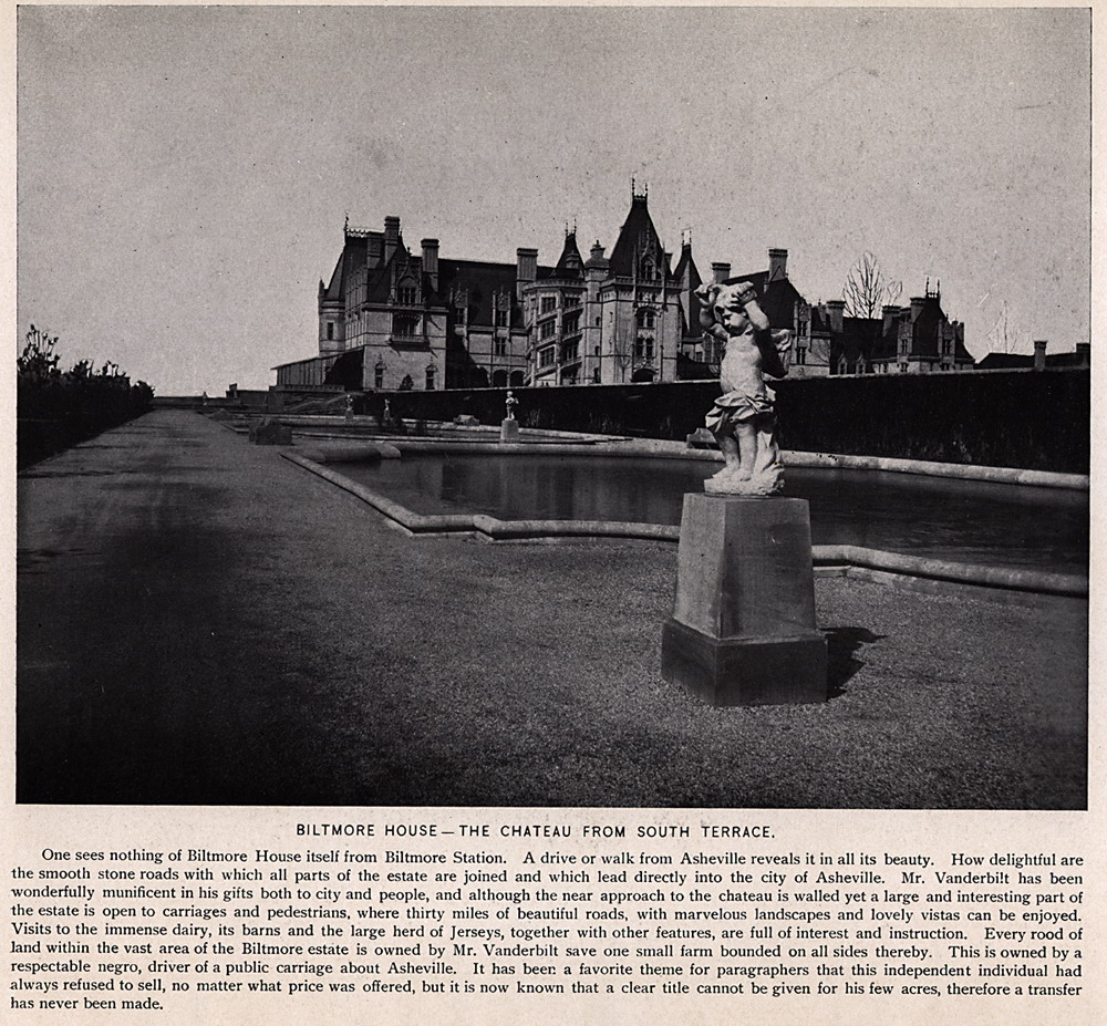
| 2 | lots002 |
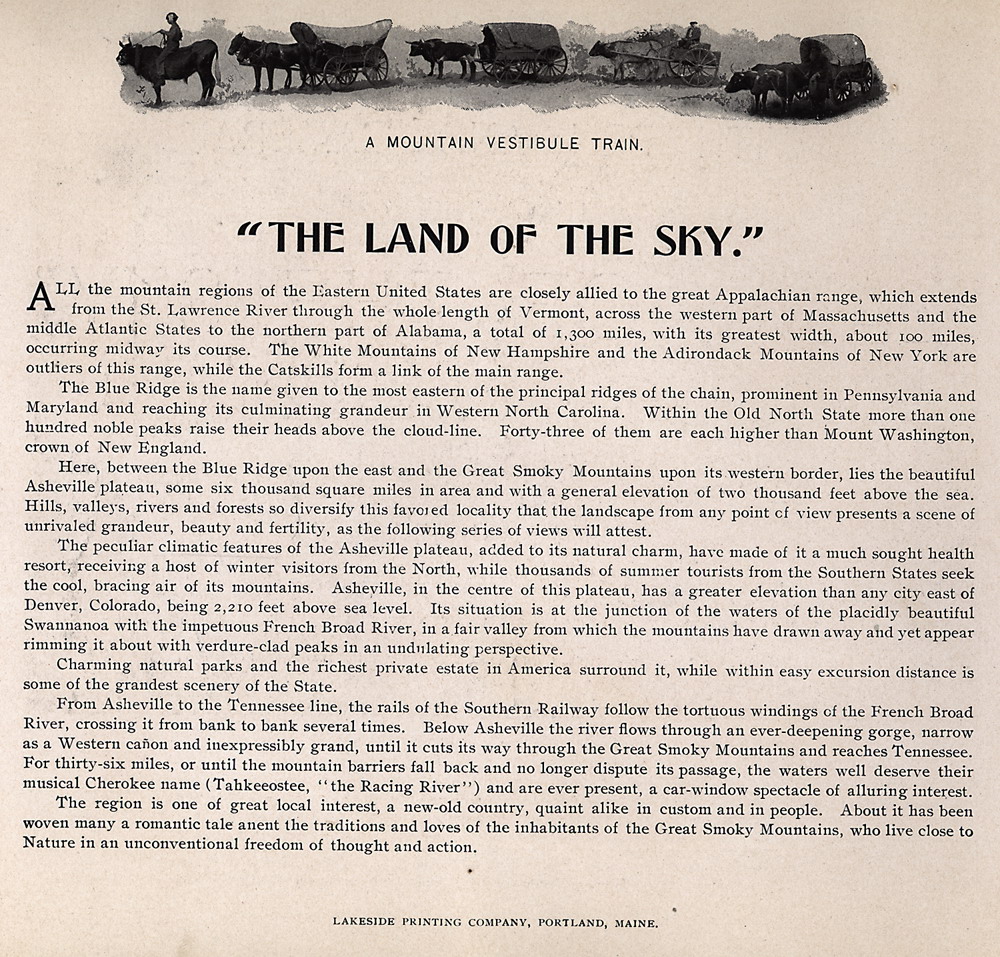
"THE LAND OF THE SKY"
The Blue Ridge is the name given to the most eastern of the principal ridges of the chain, prominent in Pennsylvania and Maryland and reaching its culminating grandeur in Western North Carolina. Within the Old North State more than one hundred noble peaks raise their heads above the cloud-line. Forty-three of them are each higher than Mount Washington, crown of New England. Here, between the Blue Ridge upon the east and the Great Smoky Mountains upon its western border, lies the beautiful Asheville plateau, some six thousand square miles in area and with a general elevation of two thousand feet above the sea. Hills, valleys, rivers and forests so diversify this favored locality that the landscape from any point of view presents a scene of unrivaled grandeur, beauty and fertility, as the following series of views will attest. The peculiar climatic features of the Asheville plateau, added to its natural charm, have made of it a much sought health resort, receiving a host of winter visitors from the North, while thousands of summer tourists from the Southern States seek the cool, bracing air of its mountains. Asheville, in the centre of this plateau, has a greater elevation than any city east of Denver, Colorado, being 2,210 feet above sea level. Its situation is at the junction of the waters of the placidly beautiful Swannanoa with the impetuous French Broad River, in a fair valley from which the mountains have drawn away and yet appear rimming it about with verdure-clad peaks in an undulating perspective. Charming natural parks and the richest private estate in America surround it, while within easy excursion distance is some of the grandest scenery of the State. From Asheville to the Tennessee line, the rails of the Southern Railway follow the tortuous windings of the French Broad River, crossing it from bank to bank several times. Below Asheville the river flows through an ever-deepening gorge, narrow as a Western canon and inexpressibly grand, until it cuts its way through the Great Smoky Mountains and reaches Tennessee. For thirty-six miles, or until the mountain barriers fall back and no longer dispute its passage, the waters well deserve their musical Cherokee name (Tahkeeostee, "The Racing River") and are ever present, a car-window spectacle of alluring interest. The region is one of great local interest, a new-old country, quaint alike in custom and in people. About it has been woven many a romantic tale anent the traditions and loves of the inhabitants of the Great Smoky Mountains, who live close to Nature in an unconventional freedom of thought and action.
|
 |
| 3 | lots003 |
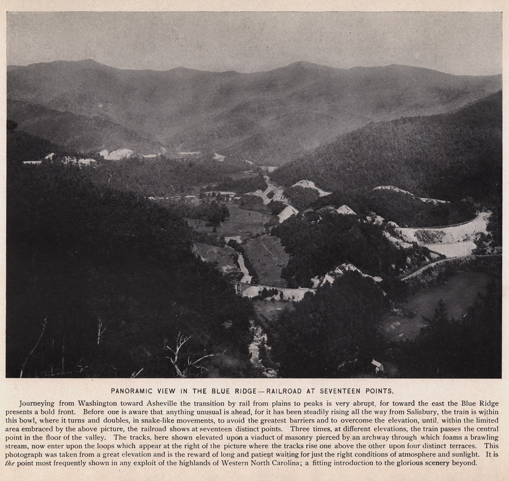
PANORAMIC VIEW IN THE BLUE RIDGE—RAILROAD AT SEVENTEEN POINTS Journeying from Washington toward Asheville the transition by rail from plains to peaks is very abrupt, for toward the east the Blue Ridge presents a bold front. Before one is aware that anything unusual is ahead, for it has been steadily rising all the way from Salisbury, the train is within this bowl, where it turns and doubles, in snake-like movements, to avoid the greatest barriers and to overcome the elevation, until, within the limited area embraced by the above picture, the railroad shows at seventeen distinct points. Three times, at different elevations, the train passes the central point in the floor of the valley. The tracks, here shown elevated upon a viaduct of masonry pierced by an archway through which foams a brawling stream, now enter upon the loops which appear at the right of the picture where the tracks rise one above the other upon four distinct terraces. This photograph was taken from a great elevation and is the reward of long and patient waiting for just the right conditions of atmosphere and sunlight. It is the point most frequently shown in any exploit of the highlands of Western North Carolina; a fitting introduction to the glorious scenery beyond.
|
 |
| 4 | lots004 | "The Blue Ridge Mountains"
and text.
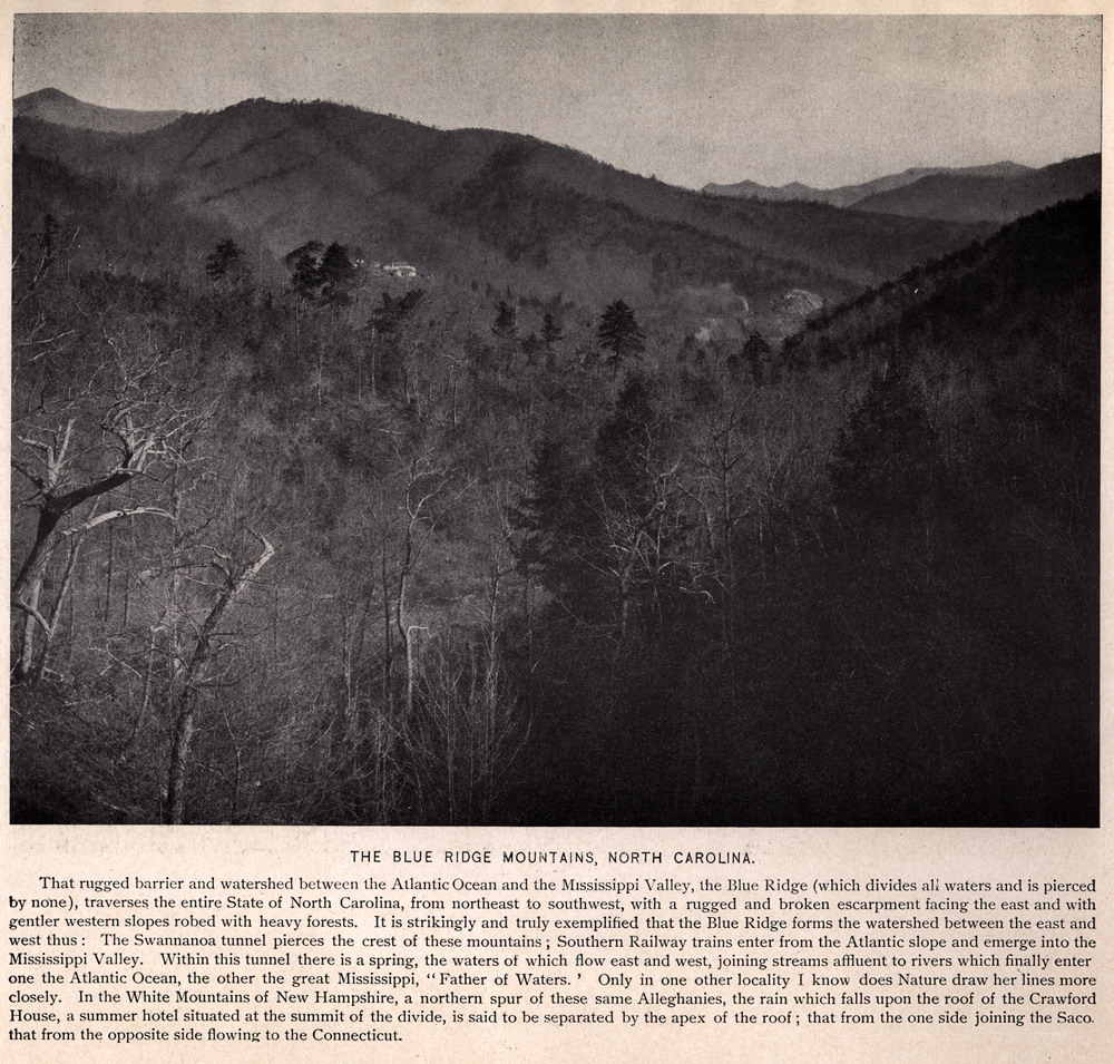
THE BLUE RIDGE MOUNTAINS, NORTH CAROLINA. That rugged barrier and watershed between the Atlantic Ocean and the Mississippi Valley, the Blue Ridge (which divides all waters and is pierced by none), traverses the entire State of North Carolina, from northeast to southwest, with a rugged and broken escarpment facing the east and with gentler western slopes robed with heavy forests. It is strikingly and truly exemplified that the Blue Ridge forms the watershed between the east and west thus : The Swannanoa tunnel pierces the crest of these mountains ; Southern Railway trains enter from the Atlantic slope and emerge into the Mississippi Valley. Within this tunnel there is a spring, the waters of which flow east and west, joining streams affluent to rivers which finally enter one the Atlantic Ocean, the other the great Mississippi, "Father of Waters." Only in one other locality I know does Nature draw her lines more closely. In the White Mountains of New Hampshire, a northern spur of these same Alleghanies, the rain which falls upon the roof of the Crawford House, a summer hotel situated at the summit of the divide, is said to be separated by the apex of the roof; that from the one side joining the Saco. that from the opposite side flowing to the Connecticut.
|
 |
| 5 | lots005 |
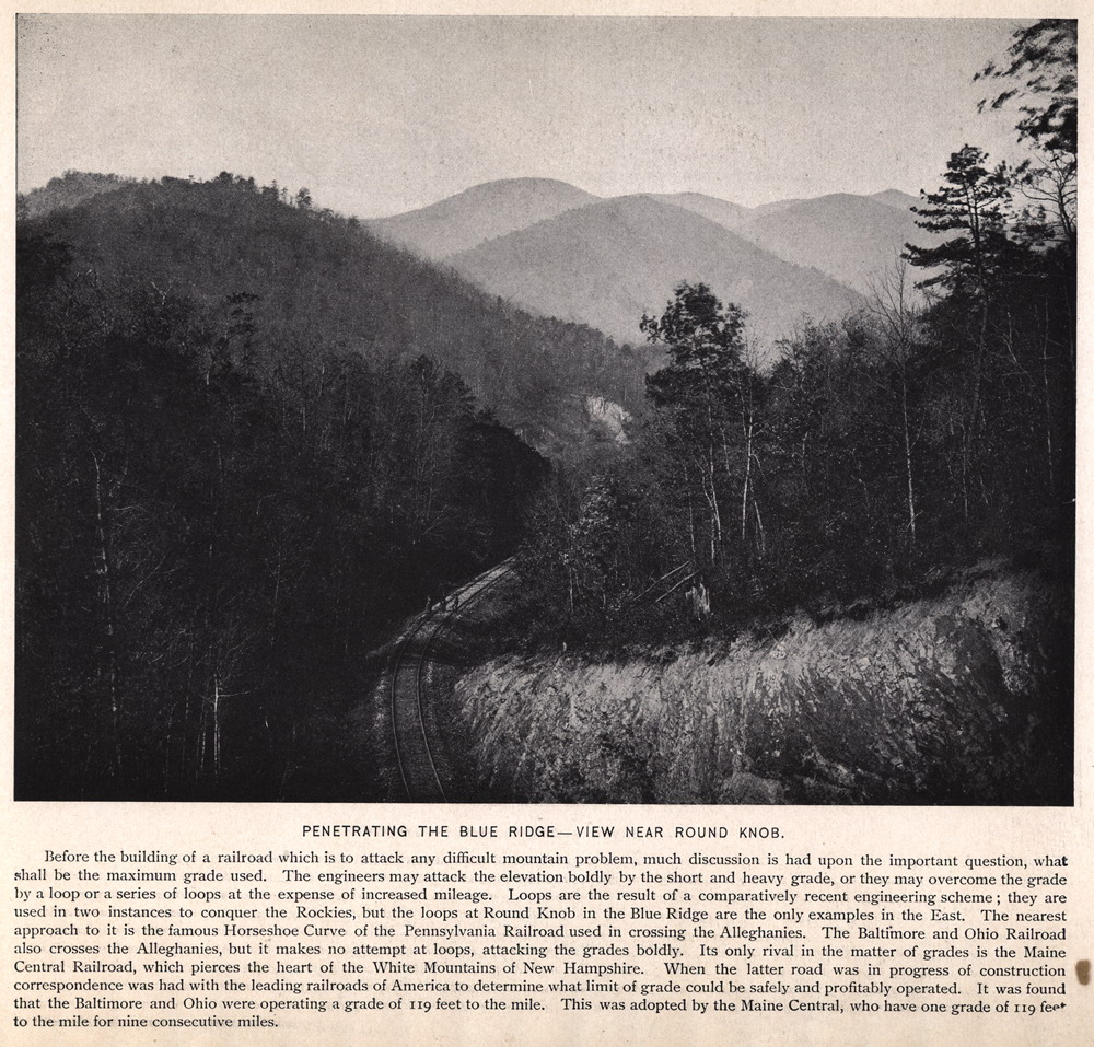
PENETRATING THE BLUE RIDGE —VIEW NEAR ROUND KNOB. Before the building of a railroad which is to attack any difficult mountain problem, much discussion is had upon the important question, what shall be the maximum grade used. The engineers may attack the elevation boldly by the short and heavy grade, or they may overcome the grade by a loop or a series of loops at the expense of increased mileage. Loops are the result of a comparatively recent engineering scheme; they are used in two instances to conquer the Rockies, but the loops at Round Knob in the Blue Ridge are the only examples in the East. The nearest approach to it is the famous Horseshoe Curve of the Pennsylvania Railroad used in crossing the Alleghanies. The Baltimore and Ohio Railroad also crosses the Alleghanies, but it makes no attempt at loops, attacking the grades boldly. Its only rival in the matter of grades is the Maine Central Railroad, which pierces the heart of the White Mountains of New Hampshire. When the latter road was in progress of construction correspondence was had with the leading railroads of America to determine what limit of grade could be safely and profitably operated. It was found that the Baltimore and Ohio were operating a grade of 119 feet to the mile. This was adopted by the Maine Central, who have one grade of 119 feet to the mile for nine consecutive miles. |
 |
| 6 | lots006 |
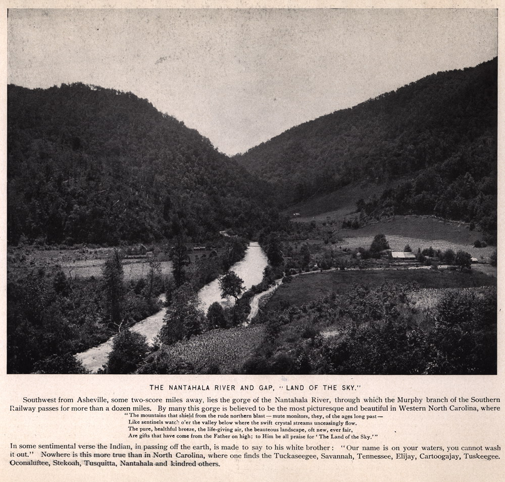
THE NANTAHALA RIVER AND GAP, "LAND OF THE SKY." Southwest from Asheville, some two-score miles away, lies the gorge of the Nantahala River, through which the Murphy branch of the Southern Railway passes for more than a dozen miles. By many this gorge is believed to be the most picturesque and beautiful in Western North Carolina, where "The mountains that shield from the rude northern blast — mute monitors, they, of the ages long past — Like sentinels watch o'er the valley below where the swift crystal streams unceasingly flow. The pure, healthful breeze, the life-giving air, the beauteous landscape, oft new, ever fair, Are gifts that have come from the Father on high; to Him be all praise for "The Land of the Sky.'" In some sentimental verse the Indian, in passing off the earth, is made to say to his white brother : "Our name is on your waters, you cannot wash it out." Nowhere is this more true than in North Carolina, where one finds the Tuckaseegee, Savannah, Tennessee, Elijay, Cartoogajay, Tuskeegee. Oconaluftee, Stekoah, Tusquitta, Nantahala and kindred others. |
 |
| 7 | lots007 |
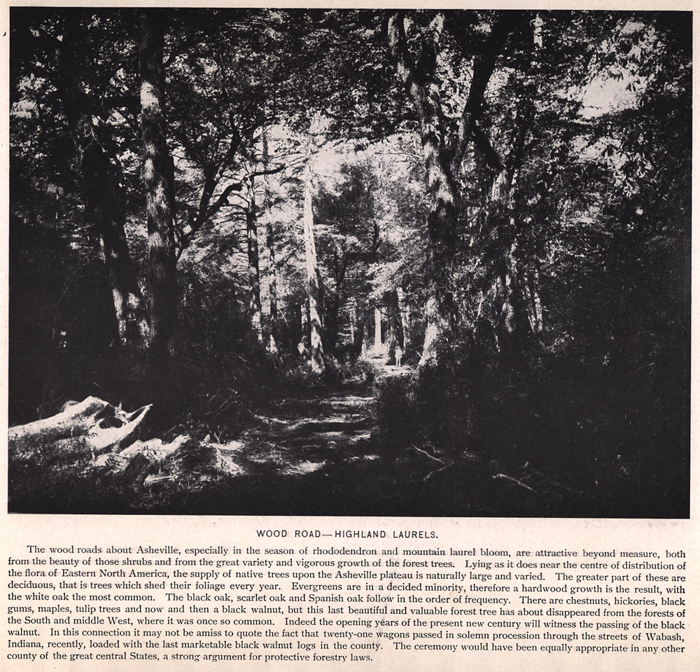
WOOD ROAD—HIGHLAND LAURELS. The wood roads about Asheville, especially in the season of rhododendron and mountain laurel bloom, are attractive beyond measure, both from the beauty of those shrubs and from the great variety and vigorous growth of the forest trees. Lying as it does near the centre of distribution of the flora of Eastern North America, the supply of native trees upon the Asheville plateau is naturally large and varied. The greater part of these are deciduous, that is trees which shed their foliage every year. Evergreens are in a decided minority, therefore a hardwood growth is the result, with the white oak the most common. The black oak, scarlet oak and Spanish oak follow in the order of frequency. There are chestnuts, hickories, black gums, maples, tulip trees and now and then a black walnut, but this last beautiful and valuable forest tree has about disappeared from the forests of the South and middle West, where it was once so common. Indeed the opening years of the present new century will witness the passing of the black walnut. In this connection it may not be amiss to quote the fact that twenty-one Wagons passed in solemn procession through the streets of Wabash, Indiana, recently, loaded with the last marketable black walnut logs in the county. The ceremony would have been equally appropriate in any other-county of the great central States, a strong argument for protective forestry laws. |
 |
| 8 | lots008 |
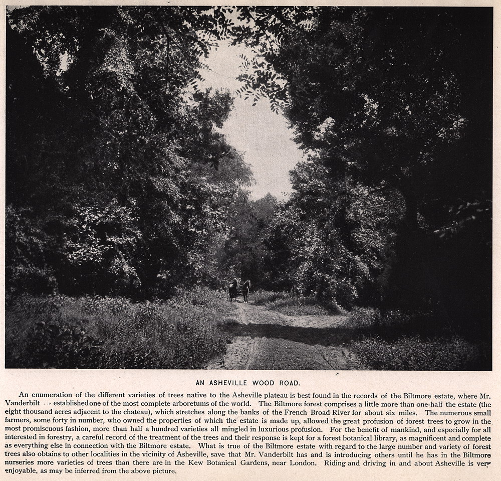
AN ASHEVILLE WOOD ROAD. An enumeration of the different varieties of trees native to the Asheville plateau is best found in the records of the Biltmore estate, where Mr. Vanderbilt established one of the most complete arboreturns of the world. The Biltmore forest comprises a little more than one-half the estate (the eight thousand acres adjacent to the chateau), which stretches along the banks of the French Broad River for about six miles. The numerous small farmers, some forty in number, who owned the properties of which the estate is made up, allowed the great profusion of forest trees to grow in the most promiscuous fashion, more than half a hundred varieties all mingled in luxurious profusion. For the benefit of mankind, and especially for all interested in forestry, a careful record of the treatment of the trees and their response is kept for a forest botanical library, as magnificent and complete as everything else in connection with the Biltmore estate. What is true of the Biltmore estate with regard to the large number and variety of forest trees also obtains to other localities in the vicinity of Asheville, save that Mr. Vanderbilt has and is introducing others until he has in the Biltmore nurseries more varieties of trees than there are in the Kew Botanical Gardens, near London. Riding and driving in and about Asheville is very enjoyable, as may be inferred from the above picture. |
 |
| 9 | lots009 |
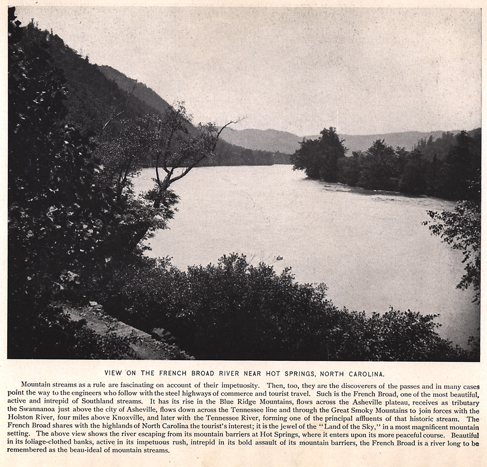
VIEW ON THE FRENCH BROAD RIVER NEAR HOT SPRINGS, NORTH CAROLINA. Mountain streams as a rule are fascinating on account of their impetuosity. Then, too, they are the discoverers of the passes and in many cases point the way to the engineers who follow with the steel highways of commerce and tourist travel. Such is the French Broad, one of the most beautiful, active and intrepid of Southland streams. It has its rise in the Blue Ridge Mountains, flows across the Asheville plateau, receives as tributary the Swannanoa just above the city of Asheville, flows down across the Tennessee line and through the Great Smoky Mountains to join forces with the Holston River, four miles above Knoxville, and later with the Tennessee River, forming one of the principal effluents of that historic stream. The French Broad shares with the highlands of North Carolina the tourist's interest; it is the jewel of the "Land of the Sky," in a most magnificent mountain setting. The above view shows the river escaping from its mountain barriers at Hot Springs, where it enters upon its more peaceful course. Beautiful in its foliage-clothed banks, active in its impetuous rush, intrepid in its bold assault of its mountain barriers, the French Broad is a river long to be remembered as the beau-ideal of mountain streams. |
 |
| 10 | lots010 |
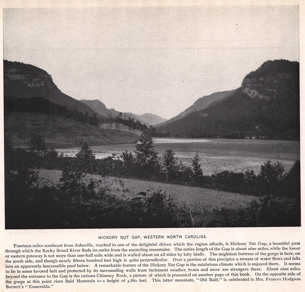
HICKORY NUT GAP, WESTERN NORTH CAROLINA. Fourteen miles southeast from Asheville, reached in one of the delightful drives which the region affords, is Hickory Nut Gap, a beautiful pass through which the Rocky Broad River finds its outlet from the encircling mountains. The entire length of the Gap is about nine miles, while the lower or eastern gateway is not more than one-half mile wide and is walled about on all sides by lofty bluffs. The mightiest buttress of the gorge is here, on the south side, and though nearly fifteen hundred feet high is quite perpendicular. Over a portion of this precipice a stream of water flows and falls into an apparently inaccessible pool below. A remarkable feature of the Hickory Nut Gap is the salubrious climate which is enjoyed there. It seems to lie in some favored belt and protected by its surrounding walls from inclement weather, frosts and snow are strangers there. About nine miles beyond the entrance to the Gap is the curious Chimney Rock, a picture of which is presented on another page of this book. On the opposite side of the gorge at this point rises Bald Mountain to a height of 3,860 feet. This latter mountain, "Old Bald," is celebrated in Mrs. Frances Hodgson Burnett's "Esmeralda." |
 |
| 11 | lots011 |
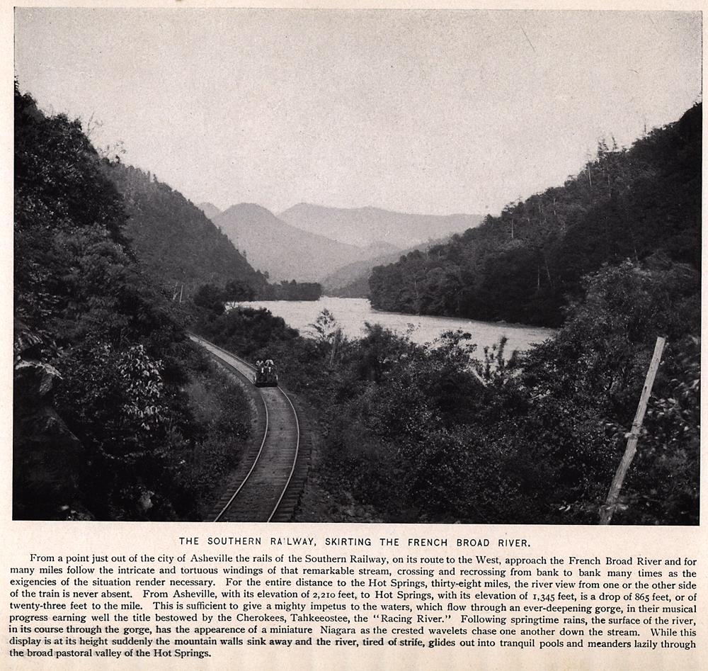
THE SOUTHERN RAILWAY, SKIRTING THE FRENCH BROAD RIVER. From a point just out of the city of Asheville the rails of the Southern Railway, on its route to the West, approach the French Broad River and for many miles follow the intricate and tortuous windings of that remarkable stream, crossing and re-crossing from bank to bank many times as the exigencies of the situation render necessary. For the entire distance to the Hot Springs, thirty-eight miles, the river view from one or the other side of the train is never absent. From Asheville, with its elevation of 2,210 feet, to Hot Springs, with its elevation of 1,345 feet, is a drop of 865 feet, or of twenty-three feet to the mile. This is sufficient to give a mighty impetus to the waters, which flow through an ever-deepening gorge, in their musical progress earning well the title bestowed by the Cherokees, Tahkeeostee, the ''Racing River." Following springtime rains, the surface of the river, in its course through the gorge, has the appearance of a miniature Niagara as the crested wavelets chase one another down the stream. While this display is at its height suddenly the mountain walls sink away and the river, tired of strife, glides out into tranquil pools and meanders lazily through the broad pastoral valley of the Hot Springs. |
 |
| 12 | lots012 |
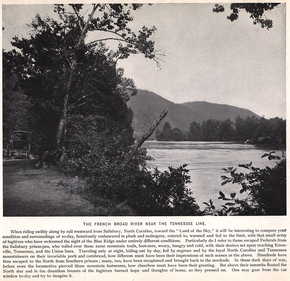
THE FRENCH BROAD RIVER NEAR THE TENNESSEE LINE. When riding swiftly along by rail westward from Salisbury, North Carolina, toward the "Land of the Sky," it will be interesting to compare your condition and surroundings of today, luxuriantly embowered in plush and mahogany, catered to, warmed and fed to the limit, with that small army of fugitives who have welcomed the sight of the Blue Ridge under entirely different conditions. Particularly do I refer to those escaped Federals from the Salisbury prison-pen, who toiled over these same mountain trails, foot-sore, weary, hungry and cold, with their desires set upon reaching Knoxville, Tennessee, and the Union lines. Traveling only at night, hiding out by day, fed by negroes and by the loyal North Carolina and Tennessee mountaineers on their invariable pork and cornbread, how different must have been their impressions of such scenes as the above. Hundreds have thus escaped to the North from Southern prisons ; many, too, have been recaptured and brought back to the stockade. In those dark days of war, before even the locomotive pierced those mountain fastnesses, how cheerless must have been their greeting. But above their summits floated the North Star and in the dauntless breasts of the fugitives burned hope and thoughts of home, so they pressed on. One may gaze from the car window today and try to imagine it. |
 |
| 13 | lots013 |
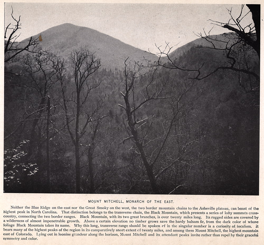
MOUNT MITCHELL, MONARCH OF THE EAST. Neither the Blue Ridge on the east nor the Great Smoky on the west, the two border mountain chains to the Asheville plateau can boast of the highest peak in North Carolina. That distinction belongs to the transverse chain, the Black Mountain, which presents a series of lofty summits cross-country, connecting the two border ranges. Black Mountain, with its two great branches, is over twenty miles long. Its rugged sides are covered by a wilderness of almost impenetrable growth. Above a certain elevation no timber grows save the hardy balsam fir, from the dark color of whose foliage Black Mountain takes its name. Why this long, transverse range should be spoken of in the singular number is a curiosity of localism, it bears many of the highest peaks of the region in its comparatively snort extent of twenty miles, and among them Mount Mitchell, the highest mountain east of Colorado. Lying out in leonine grandeur along the horizon, Mount Mitchell and its attendant peaks invite rather than repel by their graceful symmetry and color.
|
 |
| 14 | lots014 |
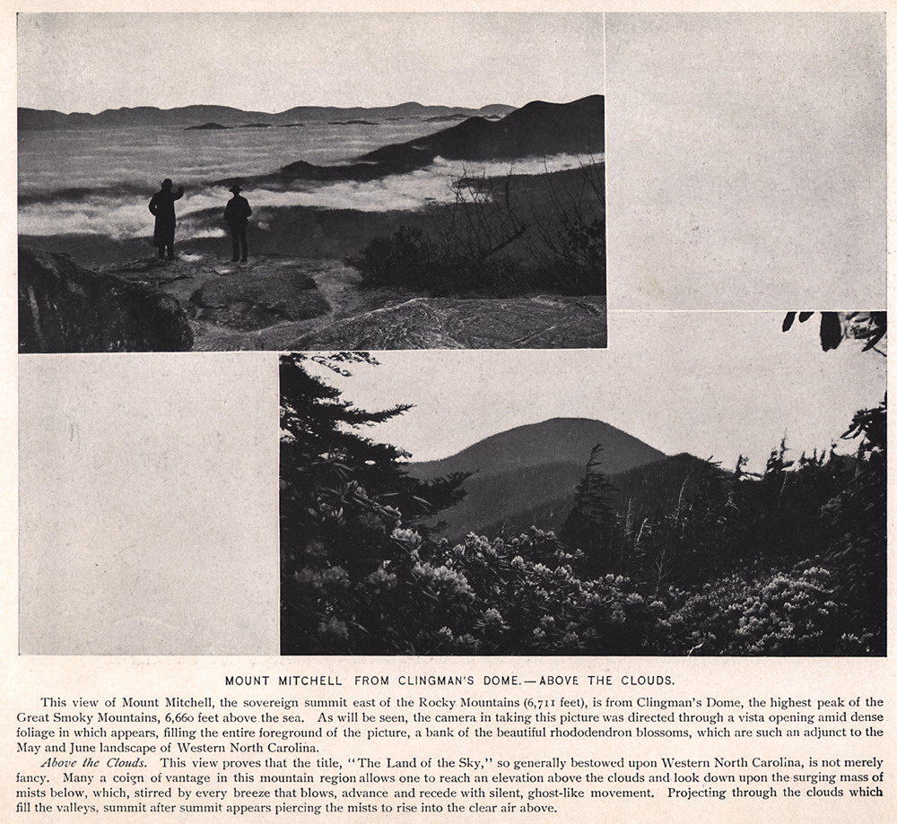
MOUNT MITCHELL FROM CLINGMAN'S DOME —ABOVE THE CLOUDS. This view of Mount Mitchell, the sovereign summit east of the Rocky Mountains (6,711 feet), is from Clingman's Dome, the highest peak of the Great Smoky Mountains, 6,660 feet above the sea. As will be seen, the camera in taking this picture was directed through a vista opening amid dense foliage in which appears, filling the entire foreground of the picture, a bank of the beautiful rhododendron blossoms, which are such an adjunct to the May and June landscape of Western North Carolina. Above the Clouds. This view proves that the title, "The Land of the Sky," so generally bestowed upon Western North Carolina, is not merely fancy. Many a coign of vantage in this mountain region allows one to reach an elevation above the clouds and look down upon the surging mass of mists below, which, stirred by every breeze that blows, advance and recede with silent, ghost-like movement. Projecting through the clouds which fill the valleys, summit after summit appears piercing the mists to rise into the clear air above. |
 |
| 15 | lots015 |
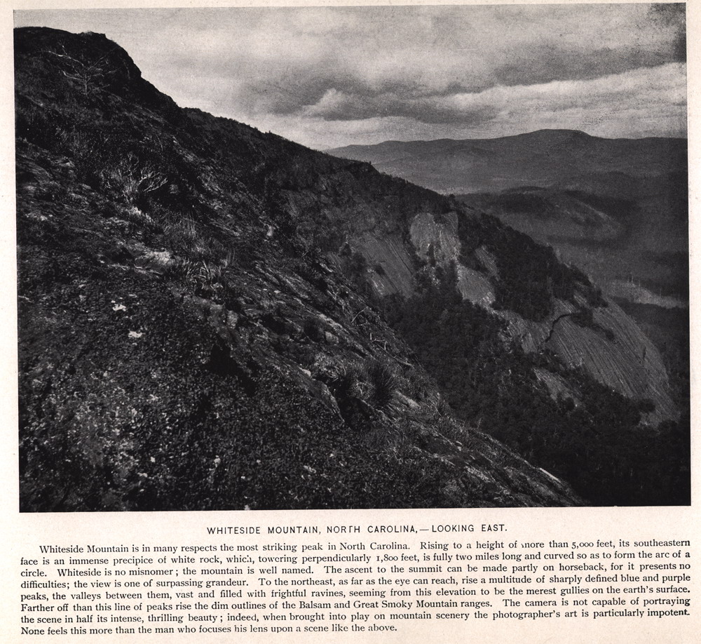
WHITESIDE MOUNTAIN, NORTH CAROLINA — LOOKING EAST. Whiteside Mountain is in many respects the most striking peak in North Carolina. Rising to a height of more than 5,000 feet, its southeastern face is an immense precipice of white rock, which, towering perpendicularly 1,800 feet, is fully two miles long and curved so as to form the arc of a circle. Whiteside is no misnomer; the mountain is well named. The ascent to the summit can be made partly on horseback, for it presents no difficulties; the view is one of surpassing grandeur. To the northeast, as far as the eye can reach, rise a multitude of sharply defined blue and purple peaks, the valleys between them, vast and filled with frightful ravines, seeming from this elevation to be the merest gullies on the earth's surface. Farther off than this line of peaks rise the dim outlines of the Balsam and Great Smoky Mountain ranges. The camera is not capable of portraying the scene in half its intense, thrilling beauty; indeed, when brought into play on mountain scenery the photographer's art is particularly impotent None feels this more than the man who focuses his lens upon a scene like the above. |
 |
| 16 | lots016 |
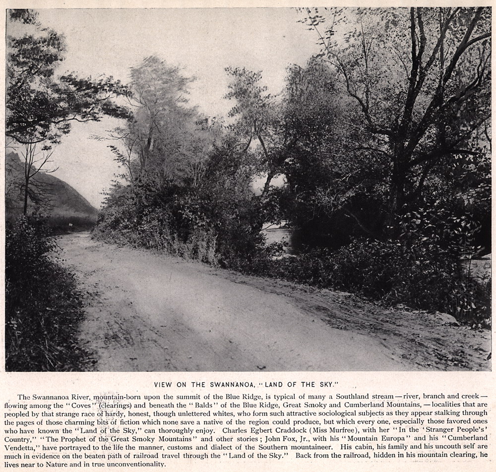
VIEW ON THE SWANNANOA, "LAND OF THE SKY." The Swannanoa River, mountain-born upon the summit of the Blue Ridge, is typical of many a Southland stream — river, branch and creek — flowing among the ''Coves'' (clearings) and beneath the ''Balds'' of the Blue Ridge, Great Smoky and Cumberland Mountains — localities that are peopled by that strange race of hardy, honest, though unlettered whites, who form such attractive sociological subjects as they appear stalking through the pages of those charming bits of fiction which none save a native of the region could produce, but which every one, especially those favored ones who have known the "Land of the Sky," can thoroughly enjoy. Charles Egbert Craddock (Miss Murfree), with her "In the 'Stranger People's' Country," "The Prophet of the Great Smoky Mountains" and other stories; John Fox, Jr., with his "Mountain Europa" and his "Cumberland Vendetta," have portrayed to the life the manner, customs and dialect of the Southern mountaineer. His cabin, his family and his uncouth self are much in evidence on the beaten path of railroad travel through the "Land of the Sky." Back from the railroad, hidden in his mountain clearing, he lives near to Nature and in true unconventionality. |
 |
| 17 | lots017 |
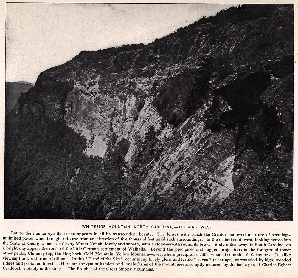
WHITESIDE MOUNTAIN, NORTH CAROLINA —LOOKING WEST. But to the human eye the scene appears in all its transcendent beauty. The lenses with which the Creator Endowed man are of seemingly unlimited power when brought into use from an elevation of five thousand feet amid such surroundings. In the distant southwest, looking across into the State of Georgia, one can descry Mount Yonah, lovely and superb, with a cloud-wreath round its brow. Sixty miles away, in South Carolina, on a bright day appear the roofs of the little German settlement of Walhalla. Beyond the precipices and ragged projections in the foreground tower other peaks, Chimney-top, the Hog-back, Cold Mountain, Yellow Mountain—everywhere precipitous cliffs, wooded summits, dark ravines. It is like viewing the world from a balloon. In this "Land of the Sky " occur many lovely glens and fertile "coves" (clearings), surrounded by high, wooded ridges and profound forests. Here are the quaint hamlets and lonely farms of the mountaineers so aptly pictured by the facile pen of Charles Egbert Craddock, notably in the story, "The Prophet of the Great Smoky Mountains."' |
 |
| 18 | lots018 |
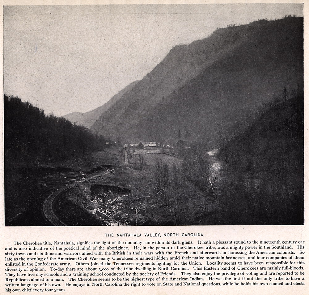
THE NANTAHALA VALLEY, NORTH CAROLINA. The Cherokee title, Nantahala, signifies the light of the noonday sun within its dark glens. It hath a pleasant sound to the nineteenth century ear and is also indicative of the poetical mind of the aborigine. He, in the person of the Cherokee tribe, was a mighty power in the Southland. His sixty towns and six thousand warriors allied with the British in their wars with the French and afterwards in harassing the American colonists. So late as the opening of the American Civil War many Cherokees remained hidden amid their native mountain fastnesses, and four companies of them enlisted in the Confederate army. Others joined the Tennessee regiments fighting for the Union. Locality seems to have been responsible for this diversity of opinion. Today there are about 3,000 of the tribe dwelling in North Carolina. This Eastern band of Cherokees are mainly full-bloods. They have five day schools and a training school conducted by the society of Friends. They also enjoy the privilege of voting and are reported to be Republicans almost to a man. The Cherokee seems to be the highest type of the American Indian. He was the first if not the only tribe to have a written language of his own. He enjoys in North Carolina the right to vote on State and National questions, while he holds his own council and elects his own chief every four years. |
 |
| 19 | lots019 |
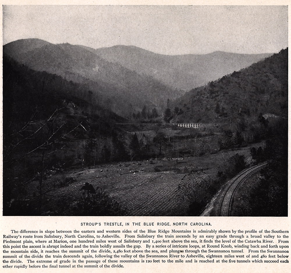
STROUP'S TRESTLE, IN THE BLUE RIDGE, NORTH CAROLINA. The difference in slope between the eastern and western sides of the Blue Ridge Mountains is admirably shown by the profile of the Southern Railway's route from Salisbury, North Carolina, to Asheville. From Salisbury the train ascends by an easy grade through a broad valley to the Piedmont plain, where at Marion, one hundred miles west of Salisbury and 1,400 feet above the sea, it finds the level of the Catawba River. From this point the ascent is abrupt indeed and the train boldly assails the gap. By a series of intricate loops, at Round Knob, winding back and forth upon the mountain side, it reaches the summit of the divide, 2,480 feet above the sea, and plunges through the Swannanoa tunnel. From the Swannanoa summit of the divide the train descends again, following the valley of the Swannanoa River to Asheville, eighteen miles west of and 480 feet below the divide. The extreme of grade in the passage of these mountains is 120 feet to the mile and is reached at the five tunnels which succeed each other rapidly before the final tunnel at the summit of the divide. |
 |
| 20 | lots020 |
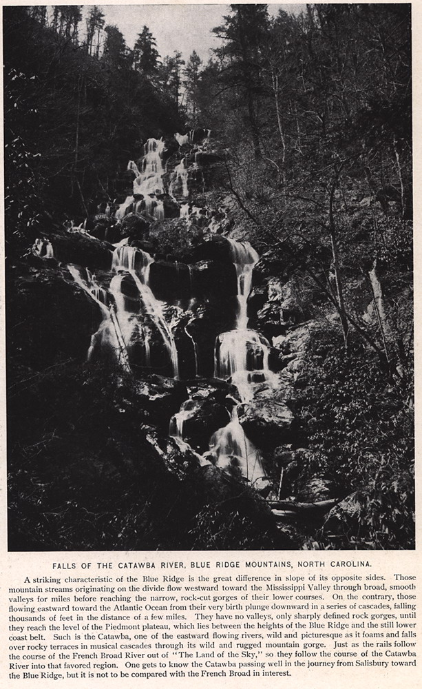
FALLS OF THE CATAWBA RIVER, BLUE RIDGE MOUNTAINS, NORTH CAROLINA. A striking characteristic of the Blue Ridge is the great difference in slope of its opposite sides. Those mountain streams originating on the divide flow westward toward the Mississippi Valley through broad, smooth valleys for miles before reaching the narrow, rock-cut gorges of their lower courses. On the contrary, those flowing eastward toward the Atlantic Ocean from their very birth plunge downward in a series of cascades, falling thousands of feet in the distance of a few miles. They have no valleys, only sharply defined rock gorges, until they reach the level of the Piedmont plateau, which lies between the heights of the Blue Ridge and the still lower coast belt. Such is the Catawba, one of the eastward flowing rivers, wild and picturesque as it foams and falls over rocky terraces in musical cascades through its wild and rugged mountain gorge. Just as the rails follow the course of the French Broad River out of ''The Land of the Sky," so they follow the course of the Catawba River into that favored region. One gets to know the Catawba passing well in the journey from Salisbury toward the Blue Ridge, but it is not to be compared with the French Broad in interest. |
 |
| 21 | lots021 |
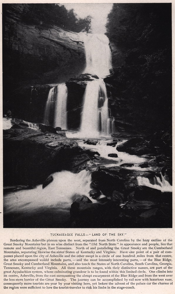
TUCKASEEGEE FALLS — "LAND OF THE SKY" Bordering the Asheville plateau upon the west, separated from North Carolina by the hazy outline of the Great Smoky Mountains but in no wise distinct from the " Old North State " in appearance and people, lies that remote and beautiful region, East Tennessee. North of and paralleling the Great Smoky are the Cumberland Mountains, separating likewise the sister States of Kentucky and Virginia. Have one point of a pair of compasses placed upon the city of Asheville and the other swept in a circle of one hundred miles from that centre, the area encompassed would include parts — and the most intensely interesting parts — of the Blue Ridge, Great Smoky and Cumberland Mountains, and also touch the States of North Carolina, South Carolina, Georgia, Tennessee, Kentucky and Virginia. All these mountain ranges, with their distinctive names, are part of the great Appalachian system, whose culminating grandeur is to be found within this limited circle. One climbs into its centre, Asheville, from the east surmounting the abrupt escarpment of the Blue Ridge and from the west over the less stern barrier of the Great Smoky. The journey can be accomplished by rail now with luxurious ease, consequently more tourists are year by year visiting here, yet before the advent of the palace car the charms of the region were sufficient to lure the tourist-traveler to risk his limbs in the stage-coach.
|
 |
| 22 | lots022 |
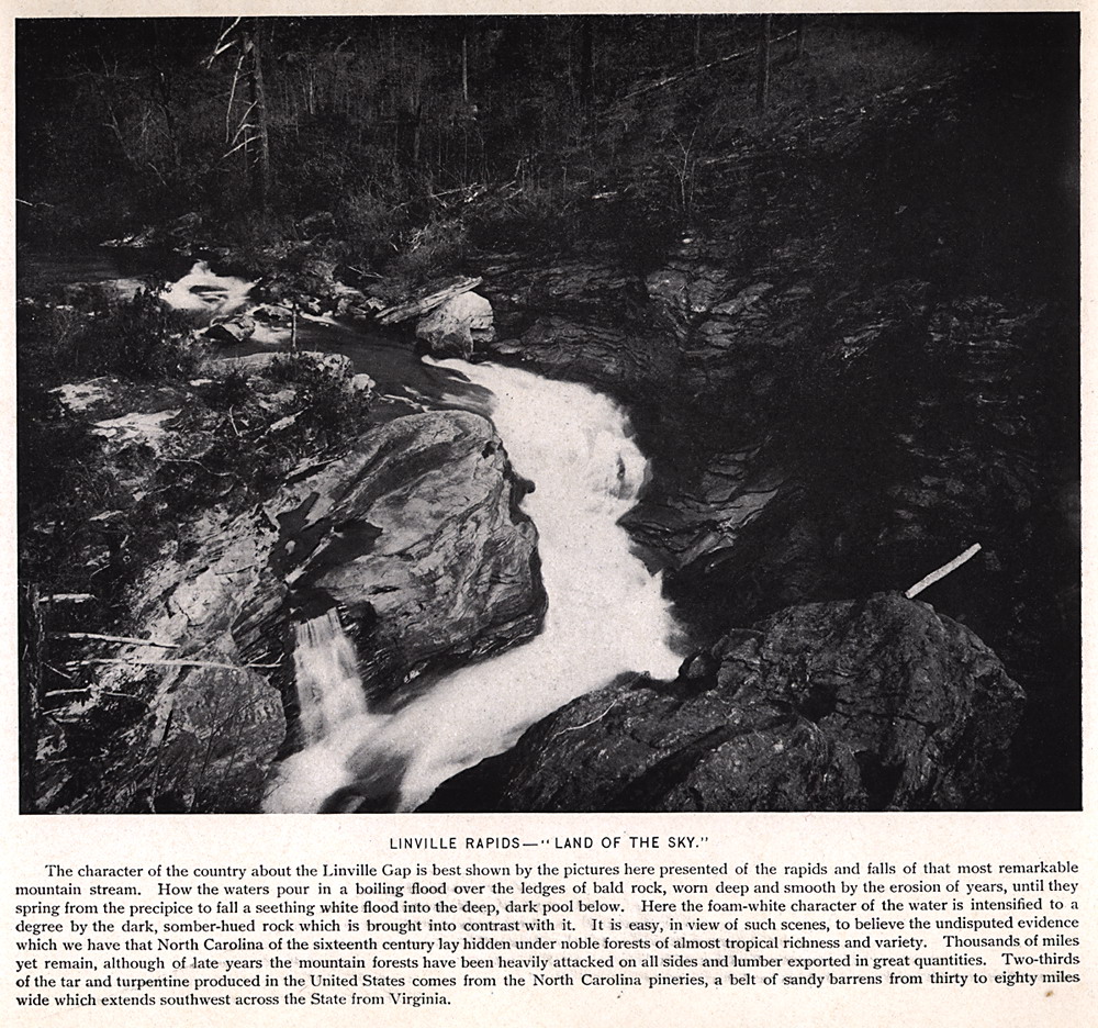
LINVILLE RAPIDS — "LAND OF THE SKY" The character of the country about the Linville Gap is best shown by the pictures here presented of the rapids and falls of that most remarkable mountain stream. How the waters pour in a boiling flood over the ledges of bald rock, worn deep and smooth by the erosion of years, until they spring from the precipice to fall a seething white flood into the deep, dark pool below. Here the foam-white character of the water is intensified to a degree by the dark, somber-hued rock which is brought into contrast with it. It is easy, in view of such scenes, to believe the undisputed evidence which we have that North Carolina of the sixteenth century lay hidden under noble forests of almost tropical richness and variety. Thousands of miles yet remain, although of late years the mountain forests have been heavily attacked on all sides and lumber exported in great quantities. Two-thirds of the tar and turpentine produced in the United States comes from the North Carolina pineries, a belt of sandy barrens from thirty to eighty miles wide which extends southwest across the State from Virginia. |
 |
| 23 | lots023 |
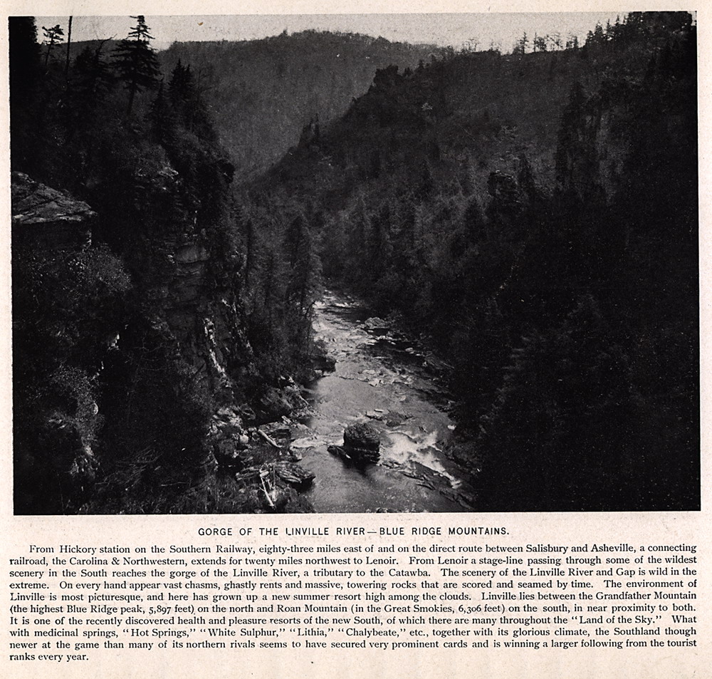
GORGE OF THE LINVILLE RIVER —BLUE RIDGE MOUNTAINS. From Hickory station on the Southern Railway, eighty-three miles east of and on the direct route between Salisbury and Asheville, a connecting railroad, the Carolina & Northwestern, extends for twenty miles northwest to Lenoir. From Lenoir a stage-line passing through some of the wildest scenery in the South reaches the gorge of the Linville River, a tributary to the Catawba. The scenery of the Linville River and Gap is wild in the extreme. On every hand appear vast chasms, ghastly rents and massive, towering rocks that are scored and seamed by time. The environment of Linville is most picturesque, and here has grown up a new summer resort high among the clouds. Linville lies between the Grandfather Mountain (the highest Blue Ridge peak, 5,897 feet) on the north and Roan Mountain (in the Great Smokies, 6,306 feet) on the south, in near proximity to both. It is one of the recently discovered health and pleasure resorts of the new South, of which there are many throughout the " Land of the Sky." What with medicinal springs, " Hot Springs," "White Sulphur," "Lithia," ''Chalybeate," etc., together with its glorious climate, the Southland though newer at the game than many of its northern rivals seems to have secured very prominent cards and is winning a larger following from the tourist ranks every year.
|
 |
| 24 | lots024 |
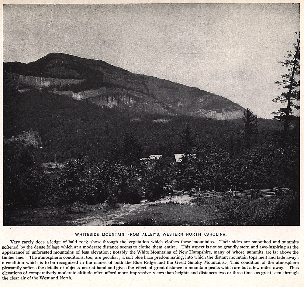
WHITESIDE MOUNTAIN FROM ALLEY'S, WESTERN NORTH CAROLINA. Very rarely does a ledge of bald rock show through the vegetation which clothes these mountains. Their sides are smoothed and summits softened by the dense foliage which at a moderate distance seems to clothe them entire. This aspect is not so grandly stern and awe-inspiring as the appearance of unforested mountains of less elevation; notably the White Mountains of New Hampshire, many of whose summits are far above the timber line. The atmospheric conditions, too, are peculiar; a soft blue haze predominating, into which the distant mountain tops melt and fade away a condition which is to be recognized in the names of both the Blue Ridge and the Great Smoky Mountains. This condition of the atmosphere pleasantly softens the details of objects near at hand and gives the effect of great distance to mountain peaks which are but a few miles away. Thus elevations of comparatively moderate altitude often afford more impressive views than heights and distances two or three times as great seen through the clear air of the West and North. |
 |
| 25 | lots025 |
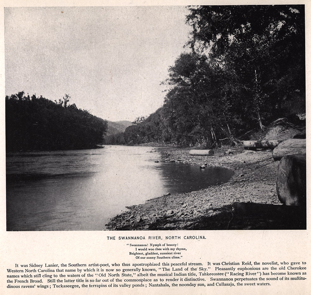
THE SWANNANOA RIVER, NORTH CAROLINA. "Swannanoa! Nymph of beauty! I would woo thee with my rhyme, Brightest, gladdest, sunniest river Of our sunny Southern clime." . It was Sidney Lanier, the Southern artist-poet, who thus apostrophized this peaceful stream. It was Christian Reid, the novelist, who gave to Western North Carolina that name by which it is now so generally known, "The Land of the Sky." Pleasantly euphonious are the old Cherokee names which still cling to the waters of the "Old North State," albeit the musical Indian title, Tahkeeostee ("Racing River") has become known as the French Broad. Still the latter title is so far out of the commonplace as to render it distinctive. Swannanoa perpetuates the sound of its multitudinous ravens wings; Tuckaseegee, the terrapins of its valley ponds; Nantahala, the noonday sun, and Cullasaja, the sweet waters. |
 |
| 26 | lots026 |
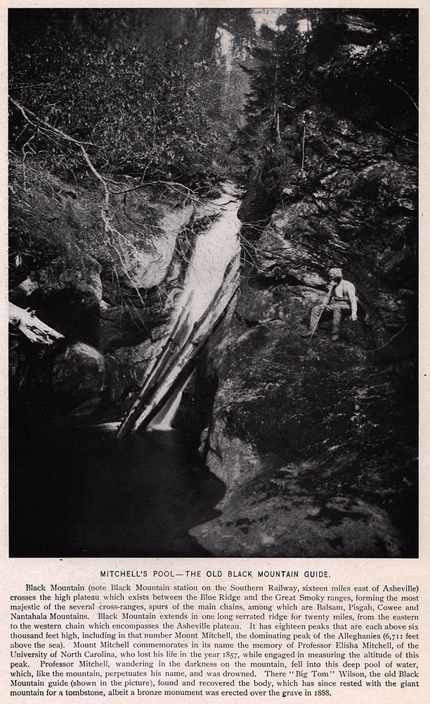
MITCHELL'S POOL —THE OLD BLACK MOUNTAIN GUIDE. Black Mountain (note Black Mountain station on the Southern Railway, sixteen miles east of Asheville) crosses the high plateau which exists between the Blue Ridge and the Great Smoky ranges, forming the most majestic of the several cross-ranges, spurs of the main chains, among which are Balsam, Pisgah, Cowee and Nantahala Mountains. Black Mountain extends in one long serrated ridge for twenty miles, from the eastern to the western chain which encompasses the Asheville plateau. It has eighteen peaks that are each above six thousand feet high, including in that number Mount Mitchell, the dominating peak of the Alleghanies (6,711 feet above the sea). Mount Mitchell commemorates in its name the memory of Professor Elisha Mitchell, of the University of North Carolina, who lost his life in the year 1857, while engaged in measuring the altitude' of this peak. Professor Mitchell, wandering in the darkness on the mountain, fell into this deep pool of water, which, like the mountain, perpetuates his name, and was drowned. There "Big Tom" Wilson, the old Black Mountain guide (shown in the picture), found and recovered the body, which has since rested with the giant mountain for a tombstone, albeit a bronze monument was erected over the grave in 1888. |
 |
| 27 | lots027 |
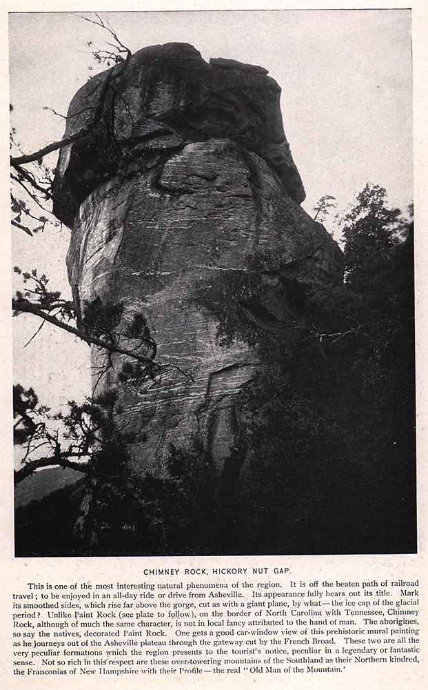
CHIMNEY ROCK, HICKORY NUT GAP. This is one of the most interesting natural phenomena of the region. It is off the beaten path of railroad travel; to be enjoyed in an all-day ride or drive from Asheville. Its appearance fully bears out its title. Mark its smoothed sides, which rise far above the gorge, cut as with a giant plane, by what — the ice cap of the glacial period? Unlike Paint Rock (see plate to follow), on the border of North Carolina with Tennessee, Chimney Rock, although of much the same character, is not in local fancy attributed to the hand of man. The aborigines, so say the natives, decorated Paint Rock. One gets a good car-window view of this prehistoric mural painting as he journeys out of the Asheville plateau through the gateway cut by the French Broad. These two are all the very peculiar formations which the region presents to the tourist's notice, peculiar in a legendary or fantastic sense. Not so rich in this respect are these over-towering mountains of the Southland as their Northern kindred, the Franconias of New Hampshire with their Profile — the real "Old Man of the Mountain.'
|
 |
| 28 | lots028 |
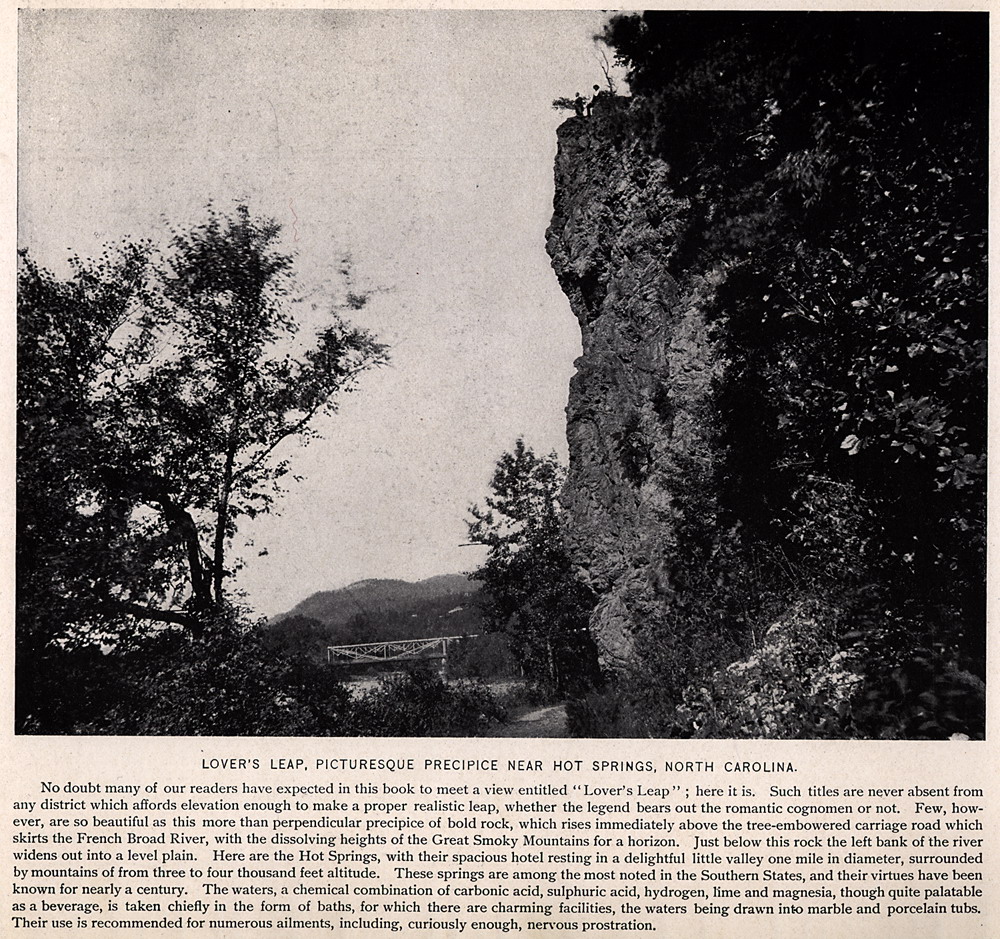
LOVER'S LEAP, PICTURESQUE PRECIPICE NEAR HOT SPRINGS, NORTH CAROLINA. No doubt many of our readers have expected in this book to meet a view entitled "Lover's Leap", here it is. Such titles are never absent from any district which affords elevation enough to make a proper realistic leap, whether the legend bears out the romantic cognomen or not. Few, however, are so beautiful as this more than perpendicular precipice of bold rock, which rises immediately above the tree-embowered carriage road which skirts the French Broad River, with the dissolving heights of the Great Smoky Mountains for a horizon. Just below this rock the left bank of the river widens out into a level plain. Here are the Hot Springs, with their spacious hotel resting in a delightful little valley one mile in diameter, surrounded by mountains of from three to four thousand feet altitude. These springs are among the most noted in the Southern States, and their virtues have been known for nearly a century. The waters, a chemical combination of carbonic acid, sulphuric acid, hydrogen, lime and magnesia, though quite palatable as a beverage, is taken chiefly in the form of baths, for which there are charming facilities, the waters being drawn into marble and porcelain tubs. Their use is recommended for numerous ailments including, curiously enough, nervous prostration. |
 |
| 29 | lots029 |
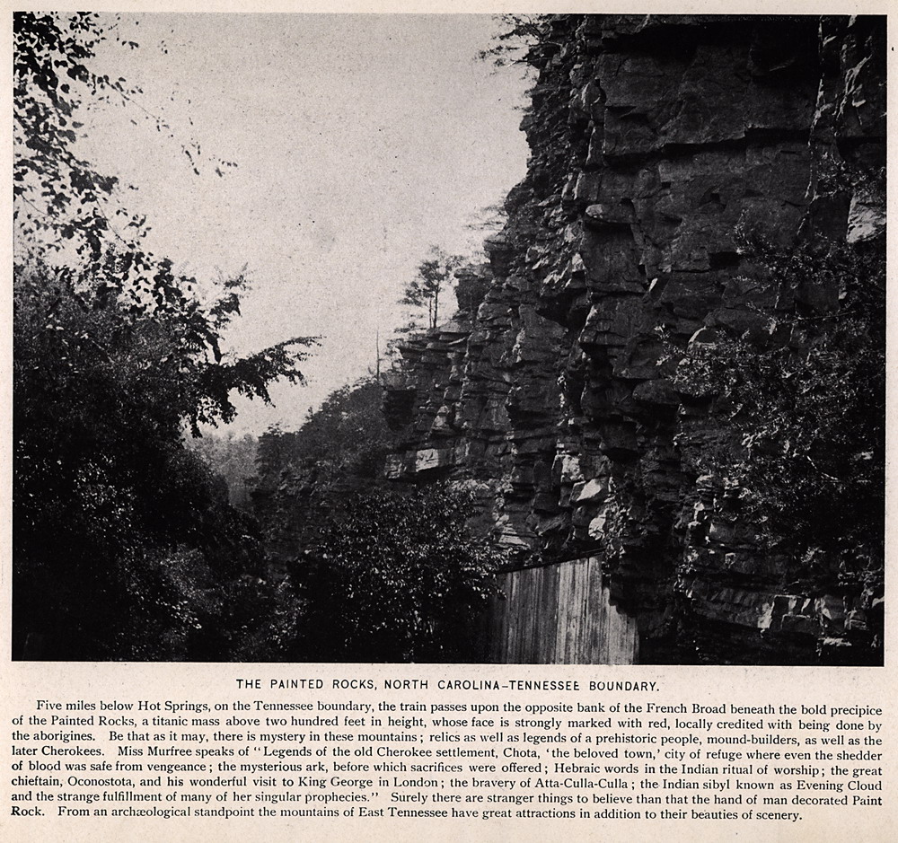
THE PAINTED ROCKS, NORTH CAROLINA-TENNESSEE BOUNDARY. Five miles below Hot Springs, on the Tennessee boundary, the train passes upon the opposite bank of the French Broad beneath the bold precipice of the Painted Rocks, a titanic mass above two hundred feet in height, whose face is strongly marked with red, locally credited with being done by the aborigines. Be that as it may, there is mystery in these mountains; relics as well as legends of a prehistoric people, mound-builders, as well as the later Cherokees. Miss Murfree speaks of "Legends of the old Cherokee settlement, Chota, 'the beloved town,' city of refuge where even the shedder of blood was safe from vengeance; the mysterious ark, before which sacrifices were offered; Hebraic words in the Indian ritual of worship; the great chieftain, Oconostota, and his wonderful visit to King George in London; the bravery of Atta-Culla-Culla; the Indian sibyl known as Evening Cloud and the strange fulfillment of many of her singular prophecies. Surely there are stranger things to believe than that the hand of man decorated Paint Rock. From an archaeological standpoint the mountains of East Tennessee have great attractions in addition to their beauties of scenery. |
 |
| 30 | lots030 |
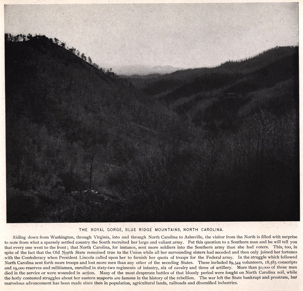
THE ROYAL GORGE, BLUE RIDGE MOUNTAINS, NORTH CAROLINA. Riding down from Washington, through Virginia, into and through North Carolina to Asheville, the visitor from the North is filled with surprise to note from what a sparsely settled country the South recruited her large and valiant army. Put this question to a Southern man and he will tell you that every one went to the front; that North Carolina, for instance, sent more soldiers into the Southern army than she had voters. This, too, in spite of the fact that the Old North State remained true to the Union while all her surrounding sisters had seceded and then only joined her fortunes with the Confederacy when President Lincoln called upon her to furnish her quota of troops for the Federal army. In the struggle which followed North Carolina sent forth more troops and lost more men than any other of the seceding States. These included 89,344 volunteers, 18,583 conscripts and 19,000 reserves and militiamen, enrolled in sixty-two regiments of infantry, six of cavalry and three of artillery. More than 50,000 of these men died in the service or were wounded in action. Many of the most desperate battles of that bloody period were fought on North Carolina soil, while the hotly contested struggles about her eastern seaports are famous in the history of the rebellion. The war left the State bankrupt and prostrate, but marvelous advancement has been made since then in population, agricultural lands, railroads and diversified industries. |
 |
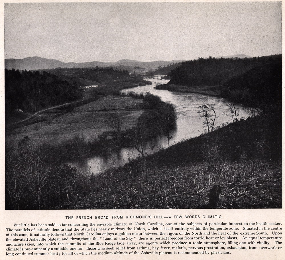
| 31 | lots031 |
THE FRENCH BROAD, FROM RICHMOND'S HILL— A FEW WORDS CLIMATIC. But little has been said so far concerning the enviable climate of North Carolina, one of the subjects of particular interest to the health-seeker. The parallels of latitude denote that the State lies nearly midway the Union, which is itself entirely within the temperate zone. Situated in the centre of this zone, it naturally follows that North Carolina enjoys a golden mean between the rigors of the North and the heat of the extreme South. Upon the elevated Asheville plateau and throughout the "Land of the Sky" there is perfect freedom from torrid heat or icy blasts. An equal temperature and azure skies, into which the summits of the Blue Ridge fade away, are agents which produce a tonic atmosphere, filling one with vitality. The climate is pre-eminently a suitable one for those who seek relief from asthma, hay fever, malaria, nervous prostration, exhaustion, from overwork or long continued summer heat; for all of which the medium altitude of the Asheville plateau is recommended by physicians. |
 |
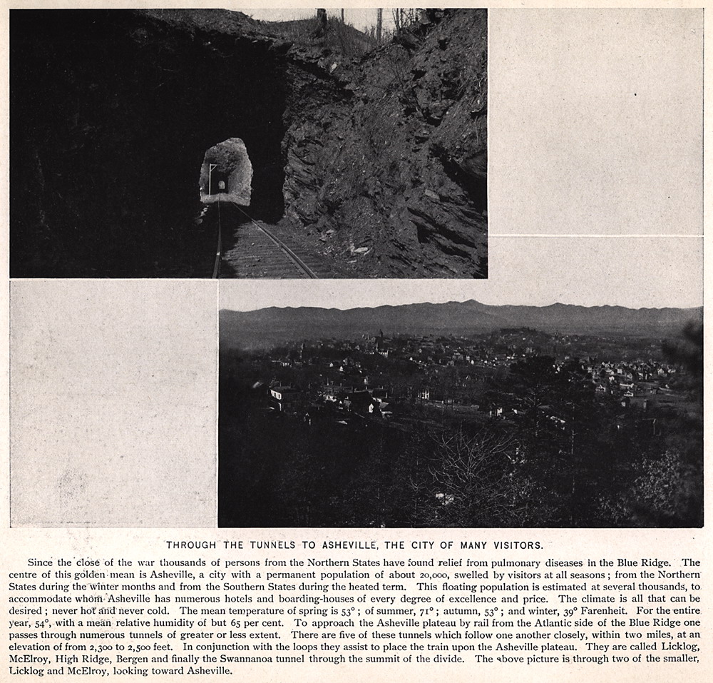
| 32 | lots032 |
THROUGH THE TUNNELS TO ASHEVILLE, THE CITY OF MANY VISITORS. Since the close of the war thousands of persons from the Northern States have found relief from pulmonary diseases in the Blue Ridge. The centre of this golden mean is Asheville, a city with a permanent population of about 20,000, swelled by visitors at all seasons; from the Northern States during the winter months and from the Southern States during the heated term. This floating population is estimated at several thousands, to accommodate whom Asheville has numerous hotels and boarding-houses of every degree of excellence and price. The climate is all that can be desired; never hot and never cold. The mean temperature of spring is 53°; of summer, 71°; autumn, 53°; and winter, 39° Fahrenheit. For the entire year, 54°, with a mean relative humidity of but 65 per cent. To approach the Asheville plateau by rail from the Atlantic side of the Blue Ridge one passes through numerous tunnels of greater or less extent. There are five of these tunnels which follow one another closely, within two miles, at an elevation of from 2,300 to 2,500 feet. In conjunction with the loops they assist to place the train upon the Asheville plateau. They are called Licklog, McElroy, High Ridge, Bergen and finally the Swannanoa tunnel through the summit of the divide. The above picture is through two of the smaller, Licklog and McElroy, looking toward Asheville. |
 |
| 33 | lots033 |
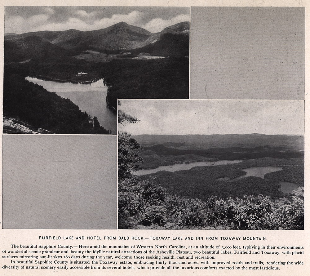
FAIRFIELD LAKE AND HOTEL FROM BALD ROCK —TOXAWAY LAKE AND INN FROM TOXAWAY MOUNTAIN. The beautiful Sapphire County — Here amid the mountains of Western North Carolina, at an altitude of 3,000 feet, typifying in their environments of wonderful scenic grandeur and beauty the idyllic natural attractions of the Asheville Plateau, two beautiful lakes, Fairfield and Toxaway, with placid surfaces mirroring sun-lit skies 280 days during the year, welcome those seeking health, rest and recreation. In beautiful Sapphire County is situated the Toxaway estate, embracing thirty thousand acres, with improved roads and trails, rendering the wide diversity of natural scenery easily accessible from its several hotels, which provide all the luxurious comforts exacted by the most fastidious. |
 |
| 34 | lots034 |
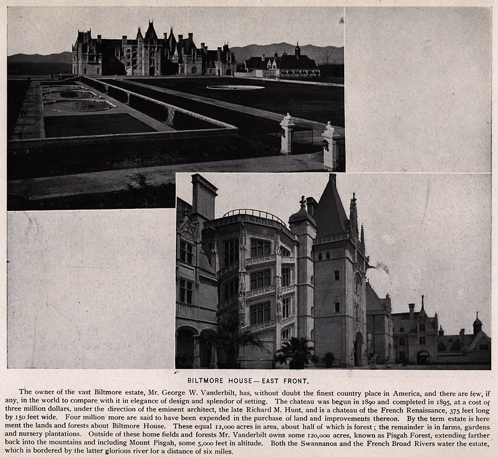
BILTMORE HOUSE—EAST FRONT. The owner of the vast Biltmore estate, Mr. George W. Vanderbilt, has without doubt the finest country place in America, and there are few, if any, in the world to compare with it in elegance of design and splendor of setting. The chateau was begun in 1890 and completed in 1895, at a cost of three million dollars, under the direction of the eminent architect, the late Richard M. Hunt, and is a chateau of the French Renaissance, 375 feet long by 150 feet wide. Four million more are said to have been expended in the purchase of land and improvements thereon. By the term estate is here meant the lands and forests about Biltmore House. These equal 12,000 acres in area, about half of which is forest; the remainder is in farms, gardens and nursery plantations. Outside of these home fields and forests Mr. Vanderbilt owns some 120,000 acres, known as Pisgah Forest, extending farther back into the mountains and including Mount Pisgah, some 5,000 feet in altitude. Both the Swannanoa and the French Broad Rivers water the estate, which is bordered by the latter glorious river for a distance of six miles. |
 |
| 35 | lots035 |
BILTMORE HOUSE — THE CHATEAU FROM SOUTH TERRACE. One sees nothing of Biltmore House itself from Biltmore Station. A drive or walk from Asheville reveals it in all its beauty. How delightful are the smooth stone roads with which all parts of the estate are joined and which lead directly into the city of Asheville. Mr. Vanderbilt has been wonderfully munificent in his gifts both to city and people, and although the near approach to the chateau is walled yet a large and interesting part of the estate is open to carriages and pedestrians, where thirty miles of beautiful roads, with marvelous landscapes and lovely vistas can be enjoyed. Visits to the immense dairy, its barns and the large herd of Jerseys, together with other features, are full of interest and instruction. Every rood of land within the vast area of the Biltmore estate is owned by Mr. Vanderbilt save one small farm bounded on all sides thereby. This is owned by a respectable negro, driver of a public carriage about Asheville. It has been a favorite theme for paragraphers that this independent individual had always refused to sell, no matter what price was offered, but it is now known that a clear title cannot be given for his few acres, therefore a transfer has never been made. |
 |
| 36 | lots036 |
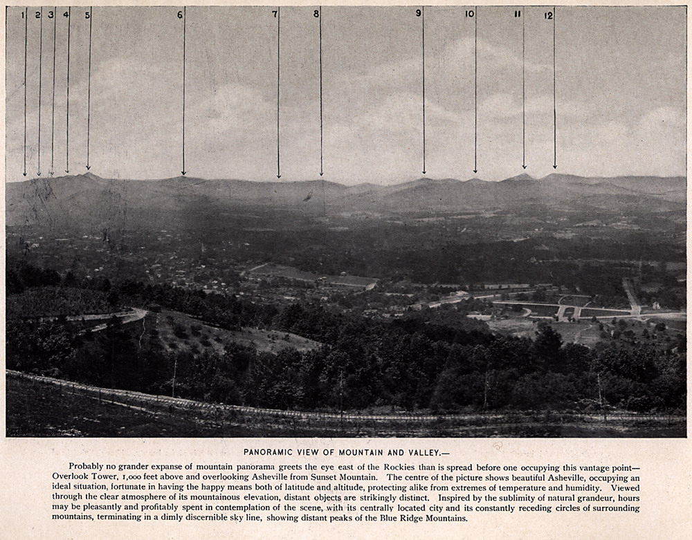
PANORAMIC VIEW OF MOUNTAIN AND VALLEY. Probably no grander expanse of mountain panorama greets the eye east of the Rockies than is spread before one occupying this vantage point — Overlook Tower, 1,000 feet above and overlooking Asheville from Sunset Mountain. The centre of the picture shows beautiful Asheville, occupying an ideal situation, fortunate in having the happy means both of latitude and altitude, protecting alike from extremes of temperature and humidity. Viewed through the clear atmosphere of its mountainous elevation, distant objects are strikingly distinct. Inspired by the sublimity of natural grandeur, hours may be pleasantly and profitably spent in contemplation of the scene, with its centrally located city and its constantly receding circles of surrounding mountains, terminating in a dimly discernible sky line, showing distant peaks of the Blue Ridge Mountains. |
 |
| 37 | lots037 |
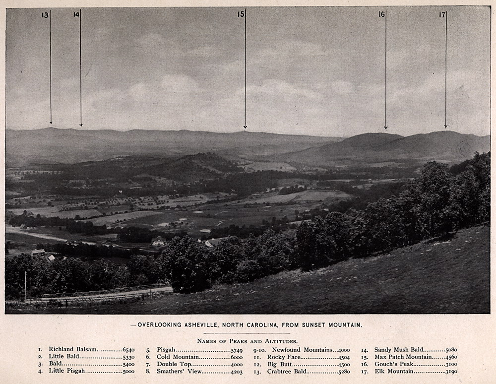
OVERLOOKING ASHEVILLE, NORTH CAROLINA, FROM SUNSET MOUNTAIN.
Names of peaks and altitudes.
1. Richland Balsam. ............6540 2. Little Bald.......................5330 3. Bald...............................5400 4. Little Pisgah....................5000 5. Pisgah.............................5749 6. Cold Mountain................6000 7. Double Top....................4000 8. Smathers' View...............4203 9-10. Newfound Mountains...4000 11. Rocky Face..................4504 12. Big Butt........................4500 13. Crabtree Bald...............5280 14. Sandy Mush Bald..........5080 15. Max Patch Mountain.....4560 16. Couch's Peak................3100 17. Elk Mountain.................3190 |
 |
| 38 | lots038 |
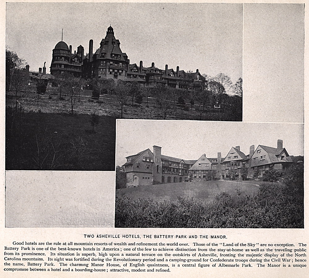
TWO ASHEVILLE HOTELS, THE BATTERY PARK AND THE MANOR. Good hotels are the rule at all mountain resorts of wealth and refinement the world over. Those of the "Land of the Sky " are no exception. The Battery Park is one of the best-known hotels in America; one of the few to achieve distinction from the stay-at-home as well as the traveling public from its prominence. Its situation is superb, high upon a natural terrace on the outskirts of Asheville, fronting the majestic display of the North Carolina mountains. Its sight was fortified during the Revolutionary period and a camping-ground for Confederate troops during the Civil War; hence the name, Battery Park. The charming Manor House, of English quaintness, is a central figure of Albemarle Park. The Manor is a unique compromise between a hotel and a boarding-house; attractive, modest and refined. |
 |
| 39 | lots039 |
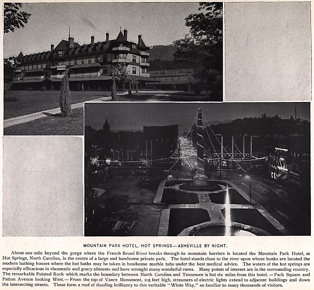
MOUNTAIN PARK HOTEL, HOT SPRINGS— ASHEVILLE BY NIGHT. About one mile beyond the gorge where the French Broad River breaks through its mountain barriers is located the Mountain Park Hotel, at Hot Springs, North Carolina, in the centre of a large and handsome private park. The hotel stands close to the river upon whose banks are located the modern bathing houses where the hot baths may be taken in handsome marble tubs under the best medical advice. The waters of the hot springs are especially efficacious in rheumatic and gouty ailments and have wrought many wonderful cures. Many points of interest are in the surrounding country. The remarkable Painted Rock which marks the boundary between North Carolina and Tennessee is but six miles from this hotel — Pack Square and Patton Avenue looking West. From the top of Vance Monument, 105 feet high, streamers of electric lights extend to adjacent buildings and down the intersecting streets. These form a roof of dazzling brilliancy to this veritable "White Way," so familiar to many thousands of visitors. |
 |
| 40 | lots040 |
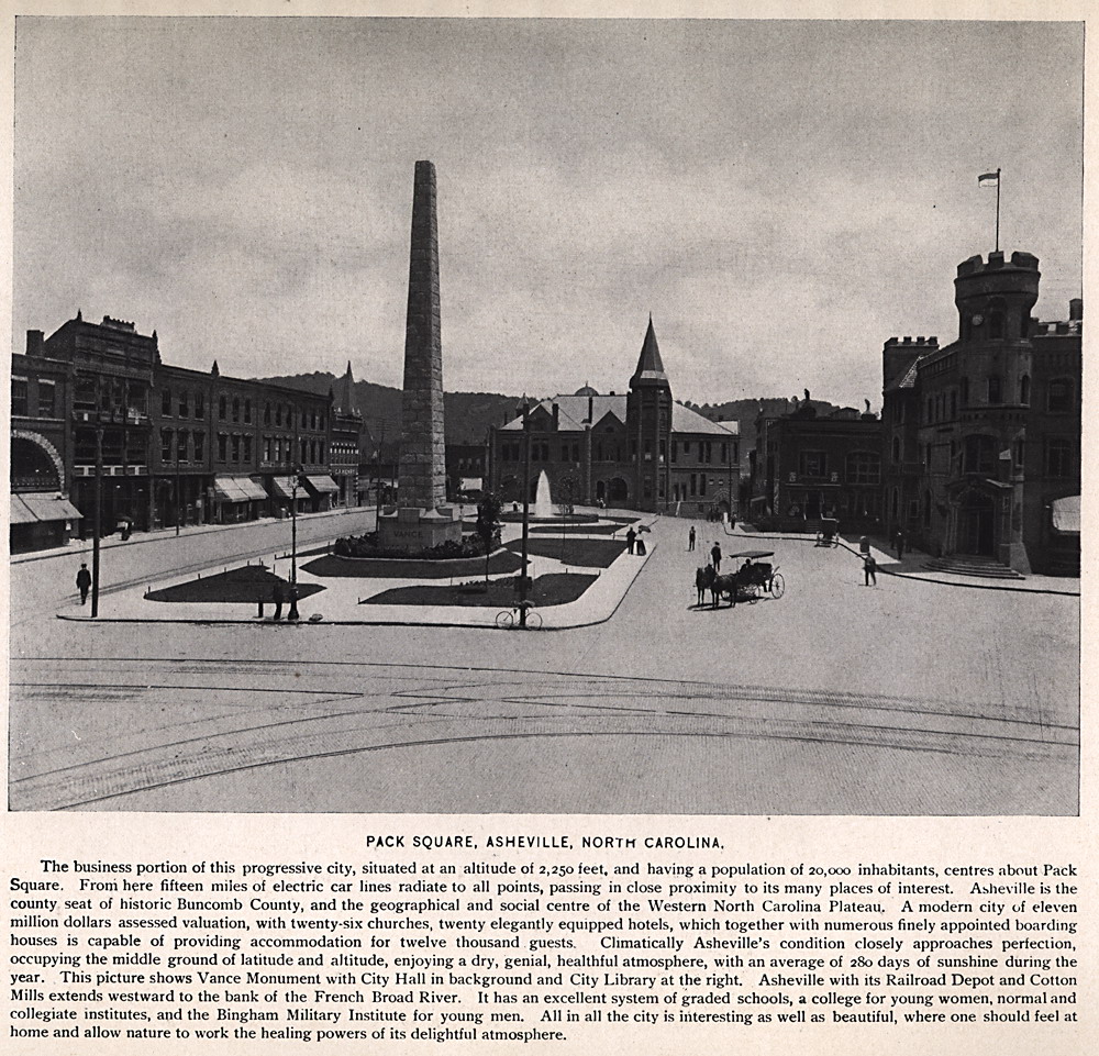
PACK SQUARE, ASHEVILLE, NORTH CAROLINA. The business portion of this progressive city, situated at an altitude of 2,250 feet, and having a population of 20,000 inhabitants, centers about Pack Square. From here fifteen miles of electric car lines radiate to all points, passing in close proximity to its many places of interest. Abbeville is the county seat of historic Buncombe County, and the geographical and social centre of the Western North Carolina Plateau. A modern city of eleven million dollars assessed valuation, with twenty-six churches, twenty elegantly equipped hotels, which together with numerous finely appointed boarding houses is capable of providing accommodation for twelve thousand guests. Climatically Asheville's condition closely approaches perfection, occupying the middle ground of latitude and altitude, enjoying a dry, genial, healthful atmosphere, with an average of 280 days of sunshine during the year. This picture shows Vance Monument with City Hall in background and City Library at the right. Asheville with its Railroad Depot and Cotton Mills extends westward to the bank of the French Broad River. It has an excellent system of graded schools, a college for young women, normal and collegiate institutes and the Bingham Military Institute for young men. All in all the city is interesting as well as beautiful, where one should feel at home and allow nature to work the healing powers of its delightful atmosphere. |
 |
| 41 | lots041 |
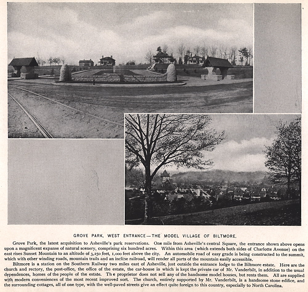
GROVE PARK, WEST ENTRANCE —THE MODEL VILLAGE OF BILTMORE. Grove Park, the latest acquisition to Asheville's park reservations. One mile from Asheville's central Square, the entrance shown above opens upon a magnificent expanse of natural scenery, comprising six hundred acres. Within this area (which extends both sides of Charlotte Avenue) on the east rises Sunset Mountain to an altitude of 3,250 feet, 1,000 feet above the city. An automobile road of easy grade is being constructed to the summit, which with other winding roads, mountain trails and an incline railroad, will render all parts of the mountain easily accessible. Biltmore is a station on the Southern Railway two miles east of Asheville, just outside the entrance lodge to the Biltmore estate. Here are the church and rectory, the post-office, the office of the estate, the car-house in which is kept the private car of Mr. Vanderbilt, in addition to the usual dependences, homes of the people of the estate. The proprietor does not sell any of the handsome model houses, but rents them. All are supplied with, modern conveniences of the most recent improved sort. The church, entirely supported by Mr. Vanderbilt, is a handsome stone edifice, and the surrounding cottages, all of one type, with the well-paved streets give an effect quite foreign to this country, especially to North Carolina. |
 |
| 42 | lots042 |
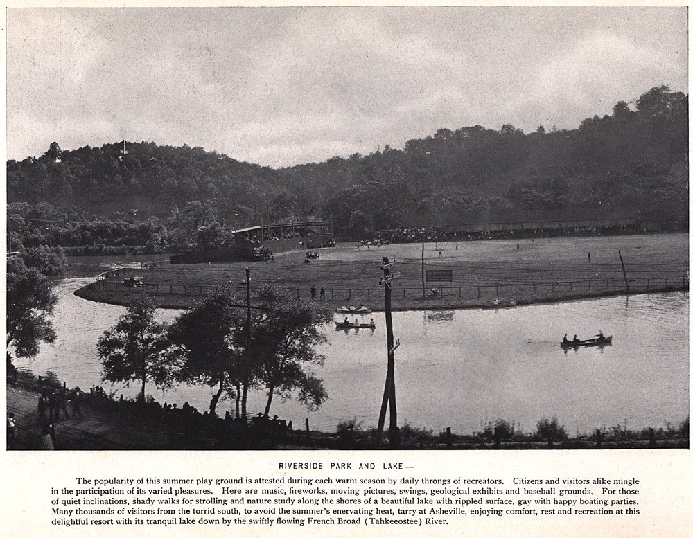
RIVERSIDE PARK AND LAKE The popularity of this summer play ground is attested during each warm season by daily throngs of recreators. Citizens and visitors alike mingle in the participation of its varied pleasures. Here are music, fireworks, moving pictures, swings, geological exhibits and baseball grounds For those of quiet inclinations, shady walks for strolling and nature study along the shores of a beautiful lake with rippled surface, gay with happy boating parties Many thousands of visitors from the torrid south, to avoid the summer's enervating heat, tarry at Asheville, enjoying comfort, rest and recreation at this delightful resort with its tranquil lake down by the swiftly flowing French Broad (Tahkeeostee) River. |
 |
| 43 | lots043 |
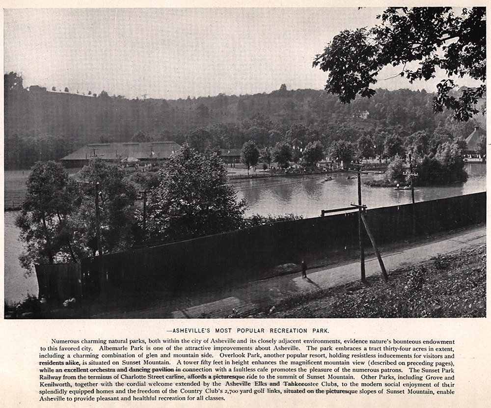
ASHEVILLE'S MOST POPULAR RECREATION PARK. Numerous charming natural parks, both within the city of Asheville and its closely adjacent environments, evidence nature's bounteous endowment to this favored city. Albemarle Park is one of the attractive improvements about Asheville. The park embraces a tract thirty-four acres in extent, including a charming combination of glen and mountain side. Overlook Park, another popular resort, holding resistless inducements for visitors and residents alike, is situated on Sunset Mountain. A tower fifty feet in height enhances the magnificent mountain view (described on preceding pages), while an excellent orchestra and dancing pavilion in connection with a faultless cafe promotes the pleasure of the numerous patrons. The Sunset Park Railway from the terminus of Charlotte Street carline, affords a picturesque ride to the summit of Sunset Mountain. Other Parks, including Grove and Kenilworth, together with the cordial welcome extended by the Asheville Elks and Tahkeeostee Clubs, to the modern social enjoyment of their splendidly equipped homes and the freedom of the Country Club's 2,700 yard golf links, situated on the picturesque slopes of Sunset Mountain, enable Asheville to provide pleasant and healthful recreation for all classes.
|
 |
| 44 | lots044 |
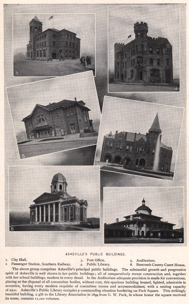
ASHEVILLE'S PUBLIC BUILDINGS. 1. City Hall. 2. Passenger Station, Southern Railway. 3. Post Office. 4. Public Library. 5. Auditorium. 6. Buncombe County Court House.
The above group comprises Asheville's principal public buildings. The substantial growth and progressive spirit of Asheville is well shown in her public buildings; all of comparatively recent construction and together with her school buildings, modern in every detail. In the Auditorium adequate provision is made for conventions, placing at the disposal of all convention bodies, without cost, this spacious building heated, lighted, admirable in acoustics, having every modern requisite of committee rooms and accommodations, with a seating capacity of 2500. Asheville's Public Library occupies a commanding situation bordering on Pack Square. This strikingly beautiful building, a gift to the Library Association in 1899 from G. W. Pack, in whose honor the square received its name, contains 11,000 volumes. |
 |
| 45 | lots045 |
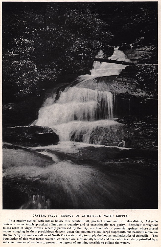
CRYSTAL FALLS —SOURCE OF ASHEVILLE'S WATER SUPPLY, By a gravity system with intake below this beautiful fall, 520 feet above and 20 miles distant, Asheville derives a water supply practically limitless in quantity and of exceptionally rare purity. Scattered throughout 10,000 acres of virgin forests, recently purchased by the city, are hundreds of perennial springs, whose crystal waters mingling in their precipitous descent down the mountain's bouldered slopes into one beautiful mountain stream, carry five million gallons of North Fork water daily to supply the houses and industries of Asheville. The boundaries of this vast forest-covered watershed are substantially fenced and the entire tract daily patrolled by a sufficient number of wardens to prevent the ingress of anything possible to pollute the waters. |
 |
| 46 | lots046 |
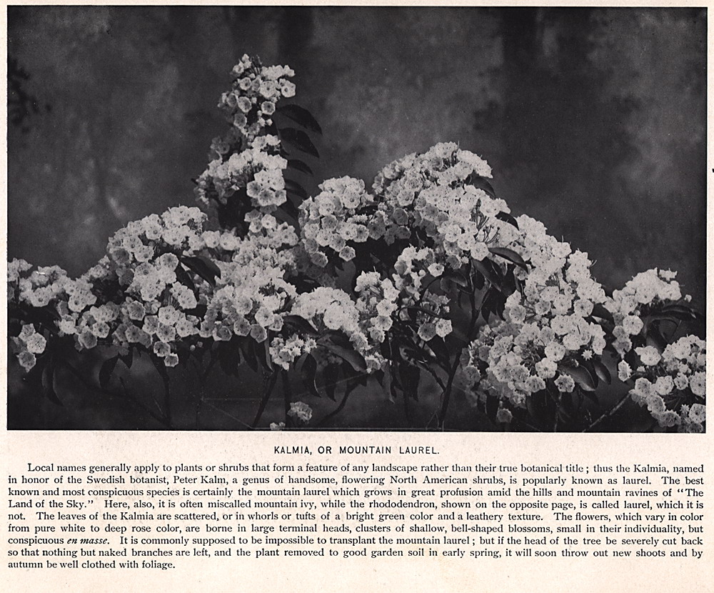
KALMIA, OR MOUNTAIN LAUREL. Local names generally apply to plants or shrubs that form a feature of any landscape rather than their true botanical title; thus the Kalmia, named in honor of the Swedish botanist, Peter Kalm, a genus of handsome, flowering North American shrubs, is popularly known as laurel. The best known and most conspicuous species is certainly the mountain laurel which grows in great profusion amid the hills and mountain ravines of "The Land of the Sky." Here, also, it is often miscalled mountain ivy, while the rhododendron, shown on the opposite page, is called laurel, which it is not. The leaves of the Kalmia are scattered, or in whorls or tufts of a bright green color and a leathery texture. The flowers, which vary in color from pure white to deep rose color, are borne in large terminal heads, clusters of shallow, bell-shaped blossoms, small in their individuality, but conspicuous en masse. It is commonly supposed to be impossible to transplant the mountain laurel; but if the head of the tree be severely cut back so that nothing but naked branches are left, and the plant removed to good garden soil in early spring, it will soon throw out new shoots and by autumn be well clothed with foliage. |
 |
| 47 | lots047 |
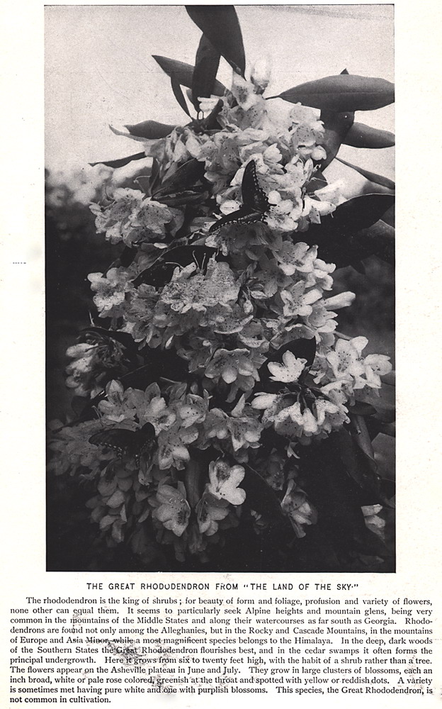
THE GREAT RHODODENDRON FROM "THE LAND OF THE SKY" The rhododendron is the king of shrubs; for beauty of form and foliage, profusion and variety of flowers, none other can equal them. It seems to particularly seek Alpine heights and mountain glens, being very common in the mountains of the Middle States and along their watercourses as far south as Georgia. Rhododendrons are found not only among the Alleghenies, but in the Rocky and Cascade Mountains, in the mountains of Europe and Asia, whilst a most magnificent species belongs to the Himalaya. In the deep, dark woods of the Southern States the Rhododendron flourishes best, and in the cedar swamps it often forms the principal undergrowth. Hereof grows from six to twenty feet high, with the habit of a shrub rather than a tree. The flowers appear on the Asheville plateau in June and July. They grow in large clusters of blossoms, each an inch broad, white of pale rose colored greenish at the throat and spotted with yellow or reddish dots. A variety is sometimes met having pure white with purplish blossoms. This species, the Great Rhododendron is not common in cultivation. |
 |
| 48 | lots048 |
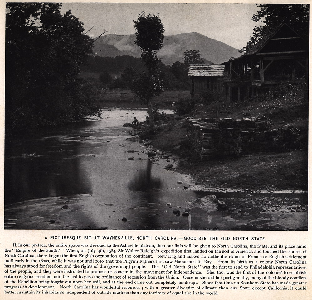
A PICTURESQUE BIT AT WAYNESVILLE, NORTH CAROLINA — GOOD-BYE THE OLD NORTH STATE. If, in our preface, the entire space was devoted to the Asheville plateau, then our finis will be given to North Carolina, the State, and its place amid the "Empire of the South." When, on July 4th, 1584, Sir Walter Raleigh's expedition first landed on the soil of America and touched the shores of North Carolina, there began the first English occupation of the continent. New England makes no authentic claim of French or English settlement until early in the i6oos, while it was not until 1620 that the Pilgrim Fathers first saw Massachusetts Bay. From its birth as a colony North Carolina has always stood for freedom and the rights of the (governing) people. The "Old North State" was the first to send to Philadelphia representatives of the people, and they were instructed to propose or concur in the movement for independence. She, too, was the first of the colonies to establish entire religious freedom, and the last to pass the ordinance of secession from the Union. Once in she did her part grandly, many of the bloody conflicts of the Rebellion being fought out upon her soil, and at the end came out completely bankrupt. Since that time no Southern State has made greater progress in development. North Carolina has wonderful resources; with a greater diversity of climate than any State except California, it could better maintain its inhabitants independent of outside markets than any territory of equal size in the world. |
 |